A vegetable grater on Mars

A vegetable grater on Mars

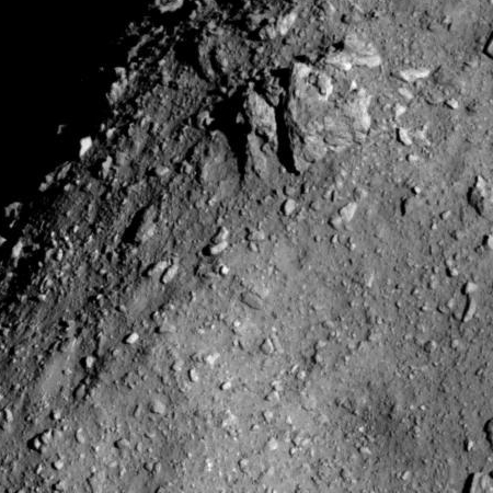
Cool image time! I honestly can’t think of any better term but “vegetable grater” to describe the strange surface in the image on the right, cropped from the full sized image that was released with the July 11, 2018 monthly release of new images from the high resolution camera on Mars Reconnaissance Orbiter (MRO).

If you click on the image you can see the whole image, which merely shows more of the same terrain over a wider area. When I cropped it, I literally picked a random 450×450 pixel-sized area, since other than slight variations the entire terrain in the full image is as equally rough. The resolution captures objects as big as five feet across.

Looking at the full image there does seem to be flow patterns moving across the middle of the image, but if so these flow patterns had no effect on the surface roughness, other than indicating a very slight difference in the size of the knobs and pits. Overall, very strange.

The location of this place on Mars is in the cratered southern highlands, to the southwest of Hellas Basin, as indicated by the black cross in the image below.
» Read more

Two roundworms return to life after being frozen for almost 42,000 years

Russian scientists have successfully brought two roundworms back to life after being frozen for almost 42,000 years.

Russian scientists said the two prehistoric worms, out of a group of about 300, are moving and eating after they came back to life in a lab at the Institute of Physico-Chemical and Biological Problems of Soil Science in Moscow, the Siberian Times reported. “After being defrosted, the nematodes showed signs of life,” a report from the Russian scientists said, according to the Siberian Times.

One of the worms was found near the Alazeya River in 2015 and is believed to be about 41,700 years old, according to the study published in the Doklady Biological Sciences. They were found about 11.5 feet underground.

The other worm was found in 2002 in a fossil rodent burrow near the Kolyma River. These samples were taken from about 100 feet underground.

If confirmed, this result is not only astonishing, it has significant implications, as it suggests that the science fiction idea of freezing people for long interstellar flights might actually be possible, eventually.

Virgin Galactic’s Unity successfully completes powered test flight

Capitalism in space: Virgin Galactic’s Unity spacecraft today successfully completed its third powered test flight, reaching an altitude of 170,800 feet, or about 32 miles.

Though this is a record flight for any of Virgin Galactic’s SpaceShipTwos, this elevation is still about half that reached by Blue Origin’s New Shepard suborbital capsule, and is considerably below the presently accepted international definition for space, which is 100 kilometers, or about 62 miles. It is getting close to the line accepted by the U.S. Air Force, 50 miles, and now being pushed by some as a better line for the beginnings of space.

Regardless, this success is good news for Virgin Galactic, as it indicates they might finally be getting close to commercial flights, after fourteen years of development.

House committee approves new space weather bill

The House Science Committee yesterday approved new space weather bill that would shift responsibility for coordinating the government’s space weather observation capabilities to the National Space Council, while also creating a pilot commercial program for launch weather satellites.

It appears there was some heavy political maneuvering involved with this bill, as there was a late switch of language that changed its focus.

The new text has a strong focus on the private sector. In the policy section, for example, it explicitly states that “space weather observation and forecasting are not exclusive functions of the Federal Government” and the government “should, as practicable, obtain space weather data and services through contracts with the commercial sector, when the data and services are available, cost-effective, and add value.” The bill requires the Secretary of Commerce to establish a pilot program for obtaining space weather data from the private sector that appears analogous to NOAA’s commercial weather data pilot program.

The Senate will still have to review and approve this new bill.

NASA wants to delay WFIRST to pay for Webb overruns

In testimony to Congress yesterday NASA administrator Jim Bridenstine said that the agency wants to delay the Wide Field Infrared Space Telescope to pay for the new cost overruns of the James Webb Space Telescope.

Bridenstine said during the hearing that no decisions had been made on how to cover those additional JWST costs. “By the 2020 timeframe is when we’re going to need to have additional funds. So between now and then we’re going to have to make determinations,” he said. “Right now that process is underway.”

He said those decisions would consider the guidance from decadal surveys and a desire to maintain a balanced portfolio of programs. He specifically assured one member, Rep. Mo Brooks (R-Ala.), that the extra funding would not come out of human spaceflight programs, particularly the Space Launch System. “This is relevant to the Science Mission Directorate exclusively, and that’s where, at this point, we’ve had discussions about what are the options going forward,” Bridenstine said.

Committee members used the two-and-a-half-hour hearing to express their frustrations with this latest delay, noting that the original concept for the mission [Webb] called for it to cost $500 million and launch in 2007, versus a current lifecycle cost of $9.6 billion and launch in 2021. “This is 19 times the original cost and a delay of 14 years,” said Rep. Lamar Smith (R-Texas), chairman of the committee. “It doesn’t get much worse than that.” [emphasis mine]

Only yesterday I speculated that the cuts to WFIRST were related to Webb. It turns out I was right.

I have highlighted above one detail revealed at the hearing. I have always thought Webb’s initial budget was $1 billion with a launch date of 2011. It appears it was less, by half, and it was supposed to launch four years sooner. Makes this boondoggle even more of an embarrassment for NASA and the astrophysics community. And for the astrophysics community it is also a disaster, because Webb’s overruns for the past two decades essentially wiped out what had been a very vibrant space astronomy program at NASA.

Changes to big August 3 commercial crew announcement do not bode well

On August 3 NASA is planning on making a big announcement concerning its commercial crew program. Yesterday the agency revealed that the NASA administrator, Jim Bridenstine, will reveal the names of the crew for the first commercial crew flight.

The changes in how that announcement will be made however suggest that they had hoped to make a bigger announcement and have been forced to back off. Initially, vice president Mike Pence was to have made the announcement. He has now canceled his participation. Also, there had previously been rumors that the announcement would have included the launch dates for both SpaceX’s and Boeing’s first flights. That the new press release makes no mention of dates suggests the dates have been delayed.

I hope I am wrong.

Ryugu as seen by Hayabusa-2 from less than 4 miles

Ryugu from less than 4 miles distance

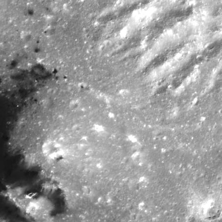
The image on the right as a cropped section of an image taken by Hayabusa-2 from only 3.7 miles distance from the asteroid Ryugu. If you click on the link you can see the full image. I picked this section to crop out because it shows the asteroid’s limb, an interesting boulder field, and part of a the asteroid’s largest crater, on the lower right. As noted by the Hayabusa-2 science team in describing details in the full image:

The resolution in Figure 1 is about 3.4 times higher than the images taken from the Home Position [20 kilometers distance] so far. 1 pixel in Figure 1 corresponds to about 60cm. The largest crater on the surface of Ryugu is situated near the center of the image and you can see that it has a shape like a “mortar”. You can also see that the surface of Ryugu is covered with a large number of boulders. This picture will provide important information as we choose the landing site.

The smallest objects visible are thus about two feet across.

NOAA still struggling to get GOES 17 working

NOAA is still struggling to pinpoint and correct the problem in GOES 17, launched in March, that prevents it from taking certain infrared weather images.

In a teleconference with reporters, NOAA officials said they had been able to improve the availability of infrared and near-infrared channels on the Advanced Baseline Imager (ABI) instrument on the GOES-17 satellite since the agency first reported the problem two months ago. The spacecraft, originally known as GOES-S, launched in March. “ABI is already demonstrating improved performance from what was initially observed,” said Pam Sullivan, director of the GOES-R system program. Currently, 13 of the instrument’s 16 channels are available 24 hours a day, with the other three able to operate at least 20 hours a day.

That will change, though, on a seasonal basis, depending on the amount of sunlight that shines into the instrument. By September, the hottest part of the orbit, only 10 of 16 channels will be available 24 hours a day, she said, with the other six available “most of the day.”

The satellite is second satellite launched out of a four satellite constellation that NOAA is building for $11 billion. They have now also admitted that the same problem exists on the first satellite, but does not seem to be effecting performance in the same way.

NASA delays launch of Parker Solar probe, again

For the second time NASA has delayed the launch of the Parker Solar probe due to issues related to the Delta IV Heavy rocket.

The United Launch Alliance Delta IV Heavy was originally scheduled to launch the Parker Solar Probe on Aug. 4, before what NASA described as “a minor tubing leak” was discovered at the processing facility in Titusville. The launch slipped to Aug. 6 and now NASA and its mission partners are targeting Aug. 11 for a 45-minute launch window at 3:48 a.m. from Cape Canaveral Air Force Station.

The latest delay comes after “a small strip of foam was found inside the (spacecraft) fairing,” during final inspections after the spacecraft was encapsulated in the Delta IV Heavy nose cone, according to NASA.

The launch window closes on August 19, so there better not be many more problems.

SpaceX and Arianespace both launch multiple satellites

Capitalism in space: SpaceX and Arianespace both had successful early morning commercial launches today.

The Ariane 5 delivered 4 Galileo GPS satellites, while SpaceX placed in orbit 10 Iridium communications satellites. SpaceX also successfully recovered the first stage.

The leaders in the 2018 launch standings:

20 China
14 SpaceX
8 Russia
5 ULA
4 Japan
4 Arianespace

In the national rankings, the U.S. and China are once again tied, now at 20-20.

Another skylight entrance pit found on Mars

Pit in Hephaestus Fossae

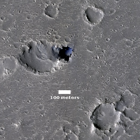
Cool image time! In my routine monthly review of the hundreds of new images released from the high resolution camera on Mars Reconnaissance Orbiter (MRO), I came across another most intriguing geological feature, the image of which is posted to the right, after cropping.

As the scale shows, the pit is about 300 feet across. Calculating the pit’s depth would require someone with better math skills than I. The website provides information about the sun angle, which can be used to extrapolate the shadows and then roughly calculate the depth.

The most fascinating aspect of this pit is the impression of incredible thinness for the pit’s overhung edges. All of the pit’s edges appear significantly overhung, and the thickness of the overhang seems incredibly paper-thin. This thinness is likely only an illusion, though in Mars’s light gravity it is perfectly possible for the overhang to be far thinner and more extended than anything you would find on Earth.

The image itself is in color, though the only color visible is within the pit itself. In that blueness at the base it seems to me that there is a pile of dust/debris, but once again, that conclusion should not be taken very seriously.

If you take a look at the full image, what is impressive is the bland flatness of the surrounding terrain. There is no hint that there might be underground passages hidden here. While most of the scattered craters are probably impact craters, many (especially those with unsymmetrical shapes) could be collapse features indicating the presence of underground voids. None however is very deep. Nor is there any other pits visible.

Below is a global map of Mars with the location of this pit indicated by a black cross. It is just on the edge of the transition zone between the lower northern plains and the southern highlands, where the shoreline of an intermittent sea is thought by some scientists to have once existed. This is also an area where not a lot of high resolution images have been taken, mostly because of its apparent blandness as seen in previous imagery.

This image demonstrates however that Mars is going to have interesting geology everywhere, and that we won’t really know it well until we have explored it all.
» Read more

Interstellar Technologies releases video of launch failure

Capitalism in space: The private Japanese company Interstellar Technologies today released a video of its June 30th launch failure.

The company is investigating the exact cause of the June 30 failure, which saw the 33-foot (10-meter) tall MOMO-2 lift off from a test site near the town of Taiki on Japan’s island of Hokkaido before crashing to the ground seconds later after it lost thrust. “The cause of the MOMO-2 failure is still under investigation,” Takahiro Inagawa, IST’s CEO, told Astrowatch.net. “However, we assume that its engine and hot-gas thruster for the roll control are responsible.

They say they are proceeding toward their third launch attempt.

[A]lthough the exact date of the launch has not been disclosed, Inagawa said that MOMO-3’s flight should be expected within months. “We will begin the next launch as soon as we are ready,” Inagawa said. “We were able to launch MOMO-2 within less than a year after MOMO-1. The launch interval of MOMO-3 and MOMO-2 will be shorter.”

I have embedded the video of the launch failure below the fold. You do want to view this. Trust me.
» Read more

Treason investigation opened against Roscosmos research unit

The Russian government has arrested at least one person and opened a treason investigation against a specific Roscosmos research unit that has been focused on hypersonic technology.

Member of the Moscow Public Monitoring Commission Yevgeny Yenikeyev earlier told TASS that a Moscow court had authorized the arrest of TsNIImash’s 74-year-old staffer Viktor Kudryavtsev accused of high treason. He didn’t specify, however, which court had sanctioned the staffer’s arrest. Ustimenko confirmed to TASS that the scientist had been taken into custody but offered no details. TsNIImash declined to comment on the information on the arrest.

The Russian business daily Kommersant earlier reported that an investigative team from the Federal Security Service (FSB) had searched the officers of TsNIImash staffers, as well as the office of Director of the Roscosmos Research and Analytical Center Dmitry Paison. According to the paper, investigative measures were being carried out as part of criminal proceedings instituted on charges of high treason under Russia’s Criminal Code, and about 10 employees working in the space industry were under investigation for collaborating with Western intelligence services.

The FSB determined that Western intelligence agencies had found out about the results of the Russian space industry’s ‘top secret’ work on hypersonic technologies, the paper reported.

I cannot help wondering if the numerous leaks by anti-Trump ideologues in the FBI, the Department of Justice, and Congress, all related to their futile effort to pin Russian collusion charges against Trump, have ended up exposing these internal sources of information in Russia.

Is the entrance to space 80 kilometers up instead of 100?

A new analysis by one scientist suggests that the official line when one enters space should be lowered from 100 kilometers to 80 kilometers.

A close look shows that the traditional definition flies in the face of evidence, says Jonathan McDowell, an astrophysicist at the Harvard-Smithsonian Center for Astrophysics in Cambridge, Massachusetts. As a hobby, McDowell compiles an influential, detailed record of rocket launches online.

…Most people continued to use 100 kilometers as a boundary, including the World Air Sports Federation (FAI) in Lausanne, Switzerland, the keeper of outer space records. Although definitions are always points of contention in science, it seemed worthwhile to McDowell to dig deeper, knowing such companies as Virgin Galactic and Blue Origin could soon be offering tourism flights to this boundary realm.

He started with data: namely, public records of satellite telemetry he had downloaded from the North American Aerospace Defense Command about the orbits of 43,000 satellites. Most didn’t matter for his project—they orbited far too high above the edge of outer space. But at least 50 had orbits that occasionally operated below 100 kilometers, such as the Soviet Elektron-4 satellite, which made 10 spins at 85 kilometers or below before disintegrating into the atmosphere in 1997. “Are you going to say [these satellites are] in space and then not in space every 2 hours?” he asked. “That doesn’t seem very helpful.” Below 80 kilometers, the story changes: It is highly unlikely a satellite will make another orbit, as thickening atmosphere sends it to a fiery end.

Considering that the Air Force has for many years used 50 miles, which is about the same as 80 kilometers, all McDowell is doing is accepting the American definition rather than an international one. It is also amusing how his actions help Virgin Galactic, since there have been rumors for years that their SpaceShipTwo design was never going to go as high as 100 kilometers, and was going to use the Air Force 50 mile definition to say their passengers reached space.

Putting Virgin Galactic aside, however, the Air Force definition has always made more sense. As McDowell notes, it better describes the dividing line between orbital space and the atmosphere where no satellite can remain in orbit.

Radiation maps of Europa

By culling together data from Voyager 1 and the Galileo orbiter, scientists have created a radiation map of the surface of Europa.

Using data from Galileo’s flybys of Europa two decades ago and electron measurements from NASA’s Voyager 1 spacecraft, Nordheim and his team looked closely at the electrons blasting the moon’s surface. They found that the radiation doses vary by location. The harshest radiation is concentrated in zones around the equator, and the radiation lessens closer to the poles.

Mapped out, the harsh radiation zones appear as oval-shaped regions, connected at the narrow ends, that cover more than half of the moon.

…In his new paper, Nordheim didn’t stop with a two-dimensional map. He went deeper, gauging how far below the surface the radiation penetrates, and building 3D models of the most intense radiation on Europa. The results tell us how deep scientists need to dig or drill, during a potential future Europa lander mission, to find any biosignatures that might be preserved.

The answer varies, from 4 to 8 inches (10 to 20 centimeters) in the highest-radiation zones – down to less than 0.4 inches (1 centimeter) deep in regions of Europa at middle- and high-latitudes, toward the moon’s poles.

This model, which by the way probably has large margins of error, will be used as a guide by the Europa Clipper scientists now planning that orbiter’s mission.

A dark dust avalanche on Mars

No dust avalanche

After dust avalanche

Cool image time! The two images to the right, both cropped to post here, were taken six years apart by Mars Reconnaissance Orbiter (MRO) of the western lava slopes of the giant volcano Olympus Mons. They show the appearance of a dark dust avalanche during the interim. As noted by members of the MRO science team.

Dust avalanches create slope streaks that expose darker materials usually hidden below a lighter-toned layer. Cascading fine-grained material easily diverts around boulders or alters direction when encountering a change in slope. The dark steak … is approximately 1 kilometer in length that we didn’t see in a previous image. Past avalanche sites are still visible and fading slowly as dust settles out of the atmosphere and is deposited on the dark streaks over time.

We also see boulders and their shadows that are a meter or greater in size. Movement of any of these boulders down the slope could trigger future avalanches.

The appearance of these Martian dark streaks on slopes is actually not uncommon. As more pictures are taken of Mars scientists are beginning to accumulate a large number all across the Martian surface.

What I find fascinating is the wet look of these dark streaks. Below is a close-up of the new avalanche, near its head.
» Read more

SpaceX successfully launches commercial communications satellite

Capitalism in space: SpaceX last night successfully launched Telstar 19v, a commercial communications satellite.

This was the second Block 5 rocket to fly successfully.

Correction: Previously I had said that these two flights served to satisfy NASA’s demands for seven successful Block 5 launches before they would certify it for commercial crew. It turns out that neither accomplishes this, because the tanks within are not the finalized versions. Thank you readers!

The leaders in the 2018 launch race:

20 China
13 SpaceX
8 Russia
5 ULA
4 Japan

In the national standings China is now only one launch ahead of the U.S., 20-19.

Starliner has propellant leak during launch abort test

Capitalism in space: Boeing’s Starliner capsule experienced a propellant leak near the end of a launch abort test in late June.

The company said it conducted a hot-fire test of the launch-abort engines on an integrated service module at the White Sands Test Facility in New Mexico in June. The engines successfully ignited and ran for the full duration, but during engine shutdown an anomaly occurred that resulted in a propellant leak. “We have been conducting a thorough investigation with assistance from our NASA and industry partners,” the statement said. “We are confident we found the cause and are moving forward with corrective action.”

The capsule being tested is an engineering model, not one that is intended to fly. Boeing also has said that “they believe there is an operational fix to the problem rather than a need to significantly rework the Starliner spacecraft itself.”

This incident however is certain to delay Boeing’s crew launch schedule, especially considering NASA’s own timidity about the privately built space capsules. The agency will insist on a complete review, no matter how long it takes, even if the company has pinpointed the problem already and has instituted corrections.

In a normal world, this event should not effect SpaceX’s schedule. I also expect however that the agency will use this event to slow SpaceX down again, demanding further reviews there as well.

Europe initiates website to name ExoMars 2020 rover

The European Space Agency has created a website where people can offer their suggestions to name the ExoMars 2020 rover.

Astronaut Tim Peake is leading the hunt for a great moniker. He wants everyone to go to a special website set up for the purpose and enter a suggestion. But don’t think “Spacey McSpaceFace” is a goer because this is not an online poll. All ideas will be put before an expert panel and it is they who will make the final choice.

If all goes right, 2020 should see two new rovers arrive on the Martian surface.

A detailed look at upcoming SpaceX launch recovery operations

Link here. They are expanding their drone fleet and their capsule recovery fleet. Though we should expect some big developments in the coming year, there was also this tidbit:

Earlier this year, the company’s president Gwynne Shotwell told CNBC that next year will see a decrease in the company’s launch cadence. The slip is due to a decline in the number of large geostationary communications satellites needing a launch.

Missions to a geostationary transfer orbit make up the majority of launches requiring a droneship recovery. Therefore, it is unlikely that two east coast droneships will be needed to support Falcon 9 over the next year or two.

It appears that after five years of effort, SpaceX has finally begun to clean out its backlog of contracted launches, caused by the initial development delays of the Falcon 9 and its two failures.

China developing a robot satellite refueling spacecraft

The new colonial movement: China today reported that it is developing a robot satellite that would attach itself to satellites that are out of fuel and use its own fuel to make the spacecraft usable again.

Hu Di, the chief designer of the vehicle, said compared with foreign research that focuses on refueling satellites that have run out of fuel, their option is much simpler and efficient. The vehicle will take about two years to complete.

Hu Di is wrong. In fact, I wonder if they have stolen this idea from Northrop Grumman, which as Orbital ATK has been developing a project exactly like this for several years.

Hayabusa-2 finds Ryugu covered with scattered large boulders

Hayabusa-2 has found that the asteroid Ryugu is covered with many scattered large boulders.

The Hayabusa 2 space probe discovered many boulders scattered on the asteroid Ryugu, suggesting it was formed from fragments of other celestial bodies, the Japan Aerospace Exploration Agency (JAXA) said July 19. More than 100 rocks larger than 8 meters in length were confirmed on the surface of the “spinning top” asteroid from images captured by Hayabusa 2, according to JAXA. The largest boulder was about 130 meters in length near the south pole.

The rocks are likely too big to be meteor fragments from collisions with Ryugu, which has a diameter of about 900 meters. “(The finding) is compelling evidence to prove that the Ryugu asteroid was formed by fragments of larger celestial bodies,” said Seiichiro Watanabe, head of the study team and professor of Nagoya University.

The asteroid’s slightly tilted axis of rotation gives Ryugu two seasons: summer and winter. Hayabusa 2 found the temperature ranged from about 20 to 100 degrees on Ryugu’s surface.

Surprise! This finding makes Ryugu very different from every other asteroid previously visited. Most have had relatively smooth surfaces, with lots of dust.

Dust storm update on Mars

Link here. This press release basically reviews what each Martian spacecraft, in orbit or on the surface, is doing to study or survive the global dust storm that erupted on Mars in in early June.

The storm itself has not yet eased, and the general expectation is that it will last for a couple of months, through August.

Global mosiacs of Titan in infrared

Titan in infrared

The Cassini science team today released global infrared mosaics of Titan, created from images accumulated during the more than 100 fly-bys of the moon during the spacecraft’s thirteen years in orbit around Saturn.

The image on the right, cropped and reduced in resolution to post here, is only one such global mosaic. Go to the story to see them all.

Making mosaics of VIMS images of Titan has always been a challenge because the data were obtained over many different flybys with different observing geometries and atmospheric conditions. One result is that very prominent seams appear in the mosaics that are quite difficult for imaging scientists to remove. But, through laborious and detailed analyses of the data, along with time consuming hand processing of the mosaics, the seams have been mostly removed. This is an update to the work previously discussed in PIA20022.

Any full color image is comprised of three color channels: red, green and blue. Each of the three color channels combined to create these views was produced using a ratio between the brightness of Titan’s surface at two different wavelengths (1.59/1.27 microns [red], 2.03/1.27 microns [green] and 1.27/1.08 microns [blue]). This technique (called a “band-ratio” technique) reduces the prominence of seams, as well as emphasizing subtle spectral variations in the materials on Titan’s surface. For example, the moon’s equatorial dune fields appear a consistent brown color here. There are also bluish and purplish areas that may have different compositions from the other bright areas, and may be enriched in water ice.

New close-up images of Ceres

Cerealia Facula on Ceres

Cool image time! The image on the right, cropped and reduced in resolution to post here, is one of two images released today by the Dawn science team of the double bright spots found in Occator Crater, taken from the spacecraft’s tight final orbit above Ceres. This image shows what they have dubbed Cerealia Facula. The second image shows Vinalia Faculae.

This mosaic of Cerealia Facula is based on images obtained by NASA’s Dawn spacecraft in its second extended mission, from an altitude as low as about 21 miles (34 kilometers). The contrast in resolution obtained by the two phases is visible here, reflected by a few gaps in the high-resolution coverage. This image is superposed to a similar scene acquired in the low-altitude mapping orbit of the mission from an altitude of about 240 miles (385 km).

Inset of Cerealia Facula

The second image on the left is a crop at full resolution of the area in the white box above. This gives you a taste of the many interesting things found in the full resolution image. For example, the bright spots scattered throughout this image suggest they are recent upwellings from below. The ridgelines in the upper right are either the remains of the water-ice volcano they think once stood here but subsequently slumped back down to form a depression, or pressure ridges being pushed up by later upwellings.

The full image has lots more. So does the image of Vinalia Faculae. Check them out.

Chinese officials quite rightly dismiss LOP-G

At a science workshop in Europe this week Chinese space officials made it clear that they found the concept of NASA Lunar Orbiting Platform-Gateway (LOP-G) to be unimpressive and uninteresting.

Moreover, they said that while it appears we will be delaying our landings on the Moon for at least a decade because of LOP-G, they will be focused on getting and building a research station on the surface, right off the bat.

Overall, Pei does not appear to be a fan of NASA’s plan to build a deep space gateway, formally known as the Lunar Orbital Platform-Gateway, at a near-rectilinear halo orbit. Whereas NASA will focus its activities on this gateway away from the Moon, Pei said China will focus on a “lunar scientific research station.”

Another slide from Pei offered some thoughts on the gateway concept, which NASA intends to build out during the 2020s, delaying a human landing on the Moon until the end of the decade at the earliest. Pei does not appear to be certain about the scientific objectives of such a station, and the deputy director concludes that, from a cost-benefit standpoint, the gateway would have “lost cost-effectiveness.”

The Chinese are right of course. LOP-G is merely a fake project to justify SLS and Orion, designed not to explore space but to provide Congress a jobs program on Earth. It will hand the Moon to China, while we dither in lunar orbit.

Another successful test flight for second New Shepard suborbital spacecraft

Capitalism in space: Blue Origin today completed another successful test flight for its second New Shepard suborbital spacecraft.

This flight tested the capsule’s launch abort capabilities. It was also this spacecraft’s third flight. The link provides a replay of the full broadcast. I have embedded this below the fold. The launch is at about 29 minutes.

More info here.
» Read more

A petition to kill SLS/Orion and LOP-G

Link here. To quote their announcement at the link:

What’s killing America’s human access to space? Three projects: a rocket called the Space Launch System, a capsule called the Orion, and a new project called the Lunar Orbital Platform-Gateway.

These three programs are political boondoggles, pork, pie in the sky, jobs programs disguised as space programs. The Space Launch System, for example, is touted as the biggest rocket ever built. But its $30 billion development cost is eating up almost all of NASA’s human budget for deep space. Compare that $30 billion with the cost of developing Elon Musk’s Falcon Heavy—less than a billion dollars. In other words, for the cost of developing the Space Launch System, we could develop thirty brand new rockets if we took the Elon Musk route. Or we could develop an entire Moon and Mars program.

After thirteen years of promises, the Space Launch System has never flown. And when it does, it will cripple NASA. The cost of one launch will be between one and two billion dollars. For that price, you could buy between eleven and 22 launches of the Falcon Heavy. You could buy the launches for an entire Moon and Mars program.

What’s worse, after the launch of each Space Launch System rocket, we will throw the exorbitantly-priced rocket away, then we will be forced to buy another one. Meanwhile, Elon Musk and Jeff Bezos are making rockets reusable. And reusable rockets, like reusable busses, trucks, trains, cars, and airplanes, will lower our cost of access to space dramatically.

Then there’s the Orion capsule that the SLS will fling into space. It cannot land. It can’t land on the Moon. It can’t land on Mars. And it’s too small to carry crews to Mars. It is a boondoggle.

Topping it all off is the Lunar Orbital Platform – Gateway, another nipple in the mouth of the Space Military Industrial Complex, another make-work program. It is a mini space station orbiting the moon. It’s useless and can’t even be manned or womanned year-round. But it will cost so much to build that we’ll never be able to build lunar landers. We won’t touch down on the moon. We’ll simply circle the moon from a distance and watch with frustration as the Chinese land human beings. [emphasis in original]

The last point about LOP-G is especially important. It is designed not to promote the exploration and settlement of the solar system, but as a kind of purgatory where the U.S. will remain trapped in lunar orbit, accomplishing nothing, while other nations land and settle the Moon.

I have signed. Anyone who has been reading Behind the Black or listening to me for the past decade will know that this has been my position, from the get-go. I am very glad that others in the space industry are now standing up to echo that position.

Mars rover update: July 17, 2018

Summary: Curiosity climbs back up onto Vera Rubin Ridge to attempt its second drillhole since drill recovery, this time at a spot on the ridge with the highest orbital signature for hematite. Opportunity remains silent, shut down due to the global dust storm.

For a list of past updates beginning in July 2016, see my February 8, 2018 update.

Curiosity

Curiosity's travels on and off Vera Rubin Ridge

For the overall context of Curiosity’s travels, see Pinpointing Curiosity’s location in Gale Crater.

In the almost two months since my May 23, 2018 update, a lot has happened, much of which I covered in daily updates. Curiosity found a good drill spot to once again test the new drilling techniques designed by engineers to bypass its stuck drill feed mechanism, and was successful in getting its first drill sample in about a year and a half. The rover then returned uphill, returning to a spot on Vera Rubin Ridge that, according to satellite data, has the highest signature for hematite on the entire ridge. The light green dotted line in the traverse map to the right shows the route Curiosity has taken back up onto Vera Rubin Ridge. The red dotted line shows the original planned route off the ridge and up Mount Sharp.
» Read more

1 236 237 238 239 240 433