The journey so far of China’s Zhurong Mars rover

Zhurong's journey on Mars, as seen by MRO
Click for full image.

Elevation map and wider overview
Click for full image.

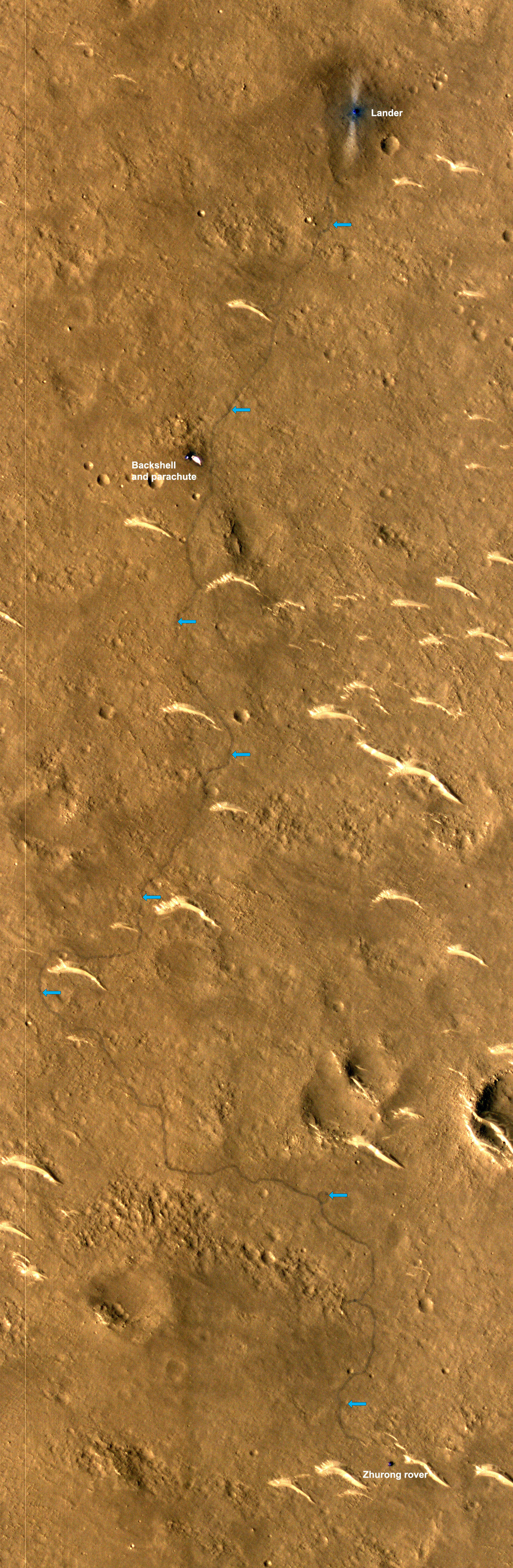
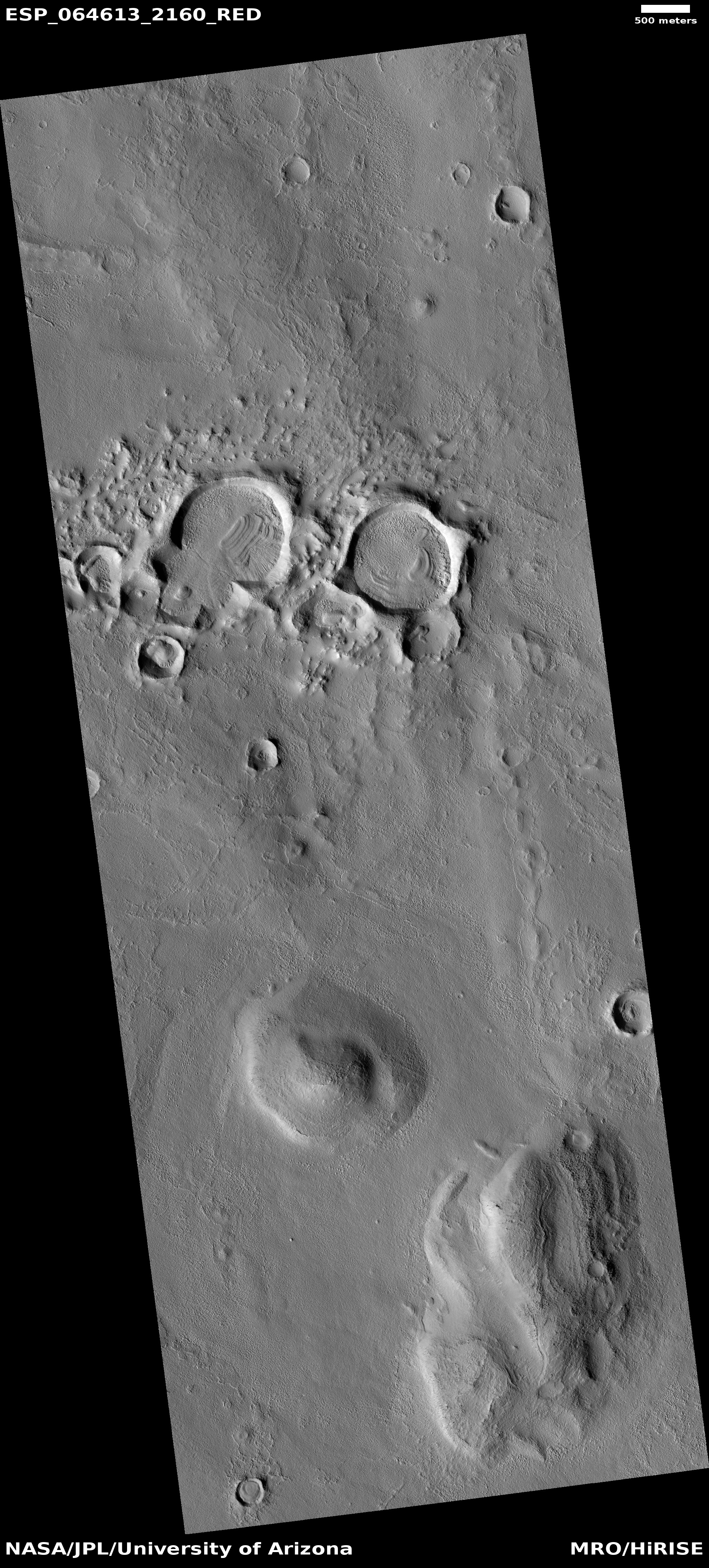
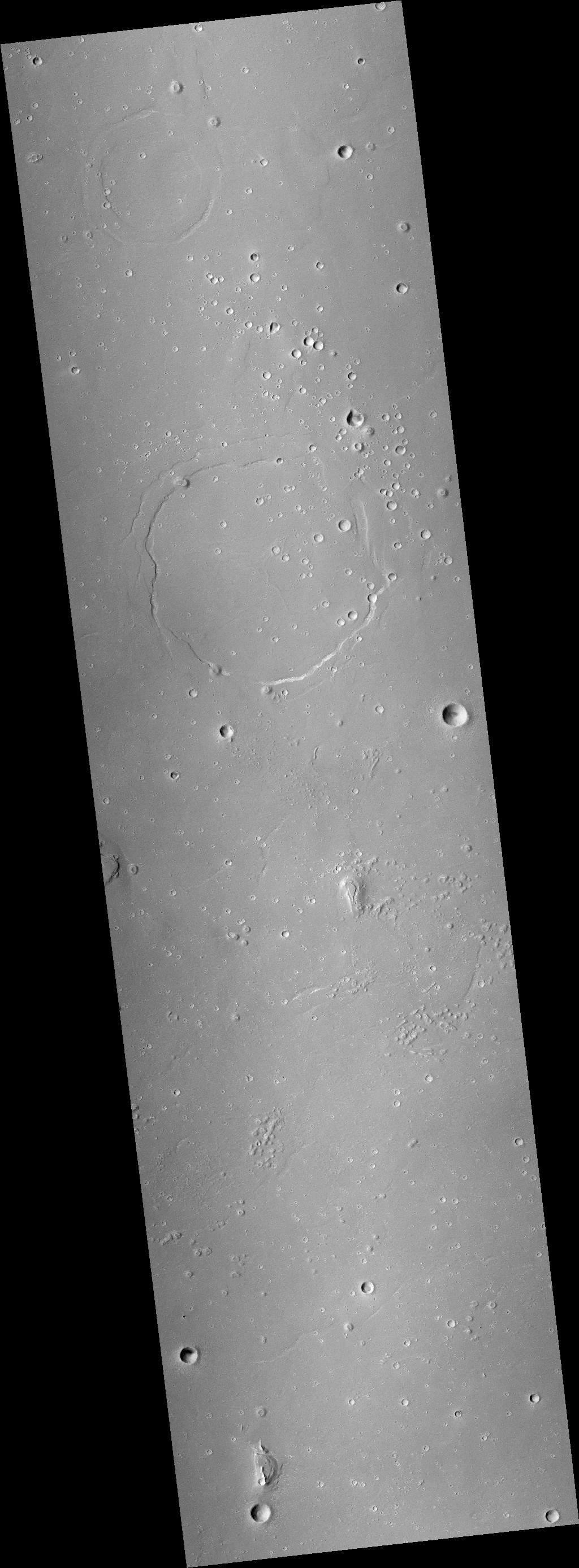
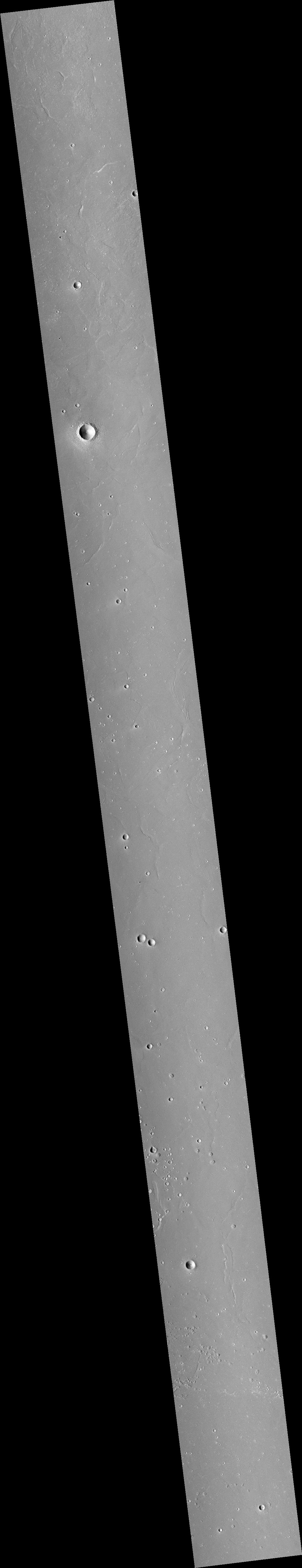
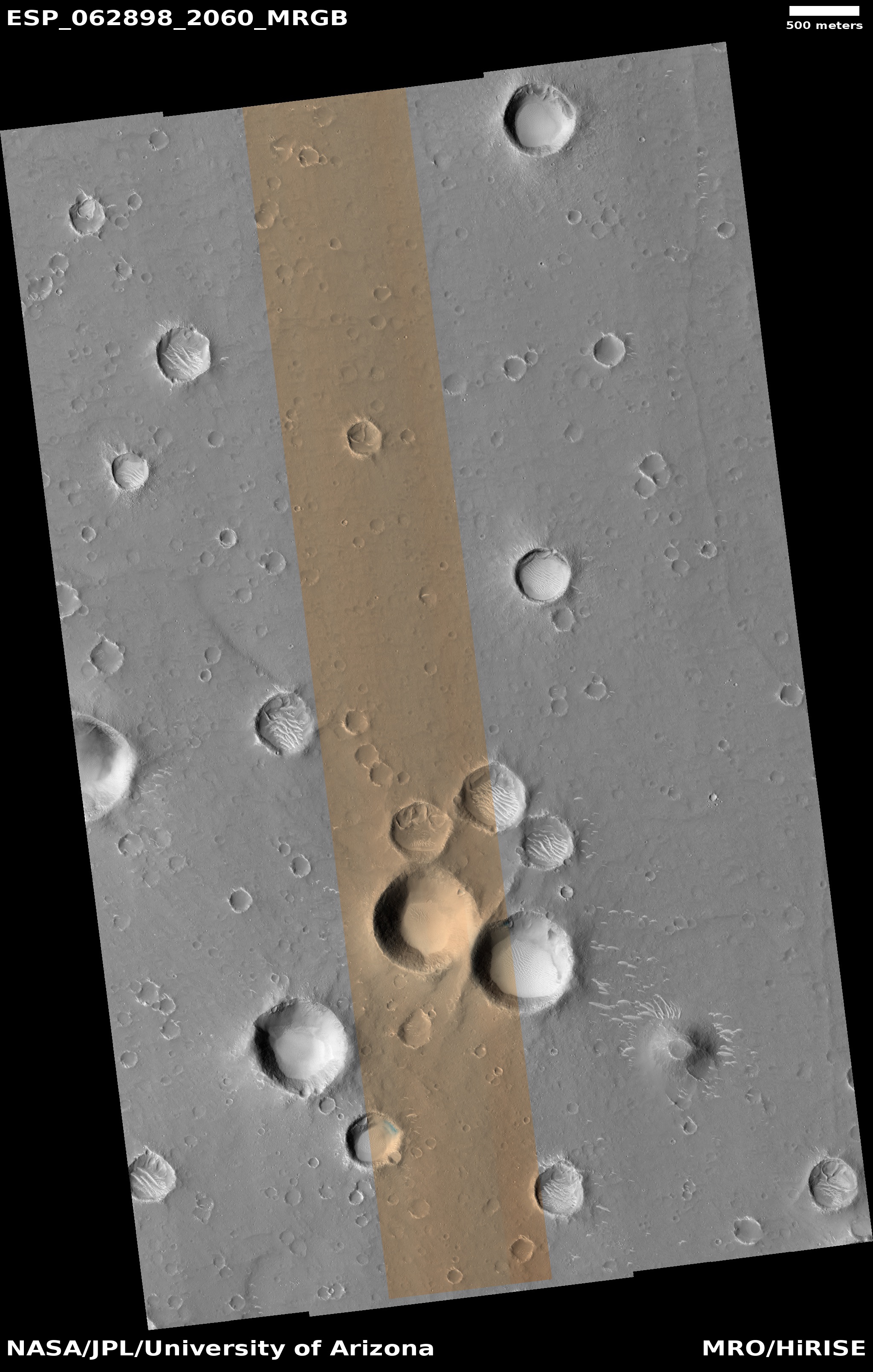
Cool image time! The science team for the high resolution camera on Mars Reconnaissance Orbiter (MRO) today released a new orbital photo that shows the entire journey on Mars of China’s Zhurong rover, since it landed in May 2021. That image, reduced to post here, is to the right. From the caption, written by Alfred McEwen of the Lunar & Planetary Laboratory in Arizona:

This HiRISE image, acquired on 11 March 2022, shows how far the rover has traveled in the 10 months since it landed.

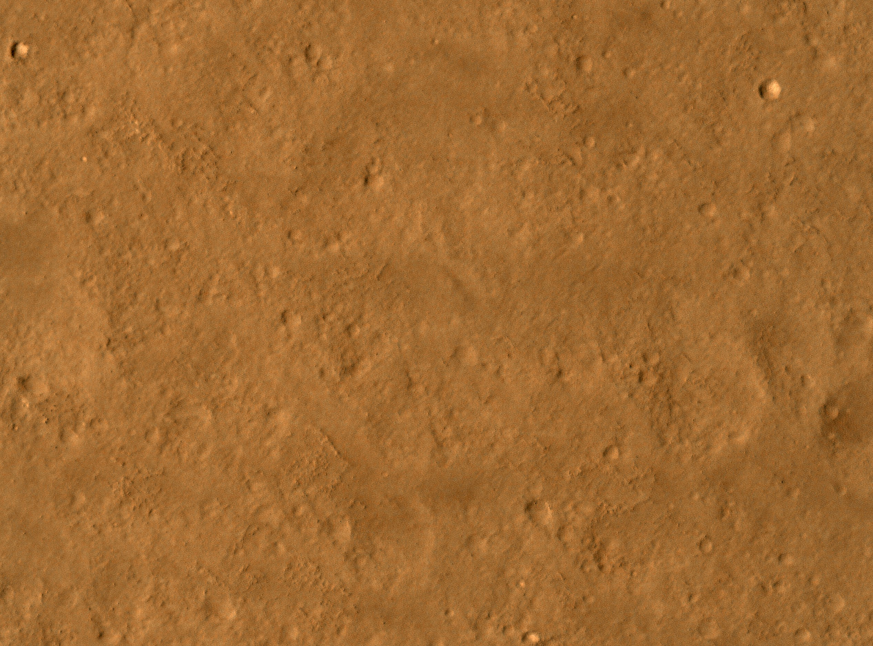
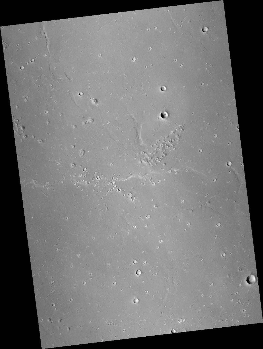
In fact, its exact path can be traced from the wheel tracks left on the surface. It has traveled south for roughly 1.5 kilometers (about 1 mile). This cutout highlights the rover and the rover’s path (with contrast enhanced to better reveal the tracks).

The white curves that the rover has apparently been inspecting as it moved south are called megaripples, mid-size sand dunes from three to six feet in height that are generally found to be inactive, though not always. From a recent report about Zhurong’s findings:

“The examples Zhurong has visited appear very bright-toned in satellite images taken from orbit, and the team thinks that this is because the megaripples are covered with a layer of very fine dust,” says Matt Balme at the Open University, UK, who wasn’t involved in the analysis. “This means these features are probably currently inactive, as any present-day windblown sand would tend to remove the dust.”

That report used data from the rover’s first sixty days on Mars, after it had passed its first megaripple and had just reached the parachute and backshell. It does not include any later data in the past eight months, as Zhurong rolled past another nine megaripples and several small craters.

It also doesn’t include any data obtained as the rover skirted the wide apron that surrounds the large depression in the lower left. That depression looks like a crater at first glance, but because it appears to be on top of a mound it could instead by an old pitted cone. There are a lot of these cones in this region of the northern lowland plains of Mars, and planetary scientists really want to know whether they were formed from erupting ice, lava, or mud.

The Chinese have so far not released any data on what they have found in these later travels. We shall have to wait for further published papers.

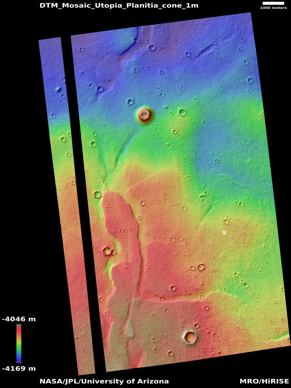
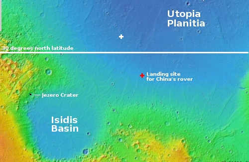
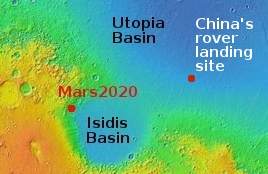
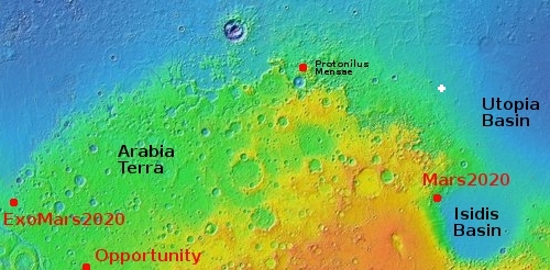
The wider elevation overview map to the right, first published on August 24, 2021 and cropped and annotated to post here, shows Zhurong’s future potential geological targets to the south. The cone to the southwest as well as the nearest scarp to the south are probably the rover’s primary goals.

Though the released results have hinted that the geology here was shaped by both wind and water, direct evidence for water has not been found, or revealed by the Chinese. Zhurong has a radar sensor that could detect evidence of near surface underground ice, if it was there. As far as I know at this point, no results from that instrument have as yet been published.

China resumes communications with Zhurong Mars rover

Elevation map of Zhurong location
Click for full image.

The new colonial movement: China yesterday announced that it has regained communications with its Zhurong rover, located in the Martian northern lowland plains of Utopia Planitia.

The image to the right, cropped and annotated by me to post here, is a digital terrain map created from two high resolution photos taken by Mars Reconnaissance Orbiter (MRO). The black line shows the route Zhurong has traveled since landing in May.

According to [Chen Baichao, the chief designer of Zhurong], the rover has traveled more than 1,000 meters since it landed on Mars at the southern part of Utopia Planitia in May 2021. After the solar conjunction, it will head south to find mud volcanoes, which scientists are interested in, located about 10 km away.

American scientists had hoped Zhurong would head north to a much larger mud cone that was much closer. Their decision to head south to the smaller cones farther away tells us that they have given themselves a much more challenging mission. It also suggests they decided it will be easier to get Zhurong closer to a smaller cone.

Based on that 10 kilometer distance, it seems the Chinese are aiming for the cones near the bottom of the map. It took Zhurong three months to travel the distance shown. At that pace, to get to those small southern mud cones will likely take, at a minimum, about fifteen months. Though the ground is quite flat, the rover will either have to negotiate one small rise of about 15 feet, or detour to the east somewhat to find a less steep route.

It is also possible that they will instead head to the mud cone south of the large impact crater. It is also a small cone, is much nearer, and will not require them to get past that rise.

A peanut-shaped crater in the northern plains of Mars

Context camera image of peanut-shaped crater
Click for full image.

Cool image time! The photo to the right, rotated, cropped and reduced to post here, was taken in May 2008 by the wide angle context camera on Mars Reconnaissance Orbiter (MRO). It shows what the scientists have since labeled a “peanut-shaped crater.”

What caused this unusual shape? The obvious and most likely explanation is that this was a double impact that occurred simultaneously. Imagine the ground being hit either by an asteroid with two lobes or by two similar-sized asteroids falling side-by-side.

Fast forward thirteen years to 2021. In the fifteen years since 2006 when MRO begin science operations in orbit around Mars no high resolution images were taken of this crater. Finally, on July 30, 2021, scientists finally decided to take a high resolution image of this crater’s western half. You can see that image below, rotated, cropped, and reduced to post here.
» Read more

Mini-volcanoes (mud or lava?) near Zhurong’s Mars landing site

Mosaic of features near Zhurong's planned landing site on Mars
Click here, here, and here for full images.

Cool image time! Though we still do not know exactly where the Chinese Mars rover Zhurong landed on Mars, we have a rough idea based on the latitude and longitude numbers leaked to the Chinese press in October 2020 and were apparently confirmed by photos taken by the Tianwen-1 orbiter soon after reaching Mars. We also know Zhurong’s engineers wanted to land in the northern lowland plains dubbed Utopia Planitia, a region that is relatively flat and thus makes a safe landing spot for their first attempt to reach the surface of Mars.

The mosaic to the right, rotated and reduced to post here, is made from three context camera images taken by Mars Reconnaissance Orbiter (MRO). The white cross on the right edge is essentially Zhurong’s leaked landing spot. The red box indicates the area covered by one of only two photos that China has released that were taken by its Tianwen-1 orbiter.

The white box in the upper left shows the area covered by today’s cool image, shown below.
» Read more

Inexplicable ridges north of China’s Mars rover

Wrinkle ridges in Utopia Planitia?
Click for full image.

Cool image time! The photo to the right, rotated, cropped, and reduced to post here, shows some unusual geology about 450 miles north of the approximate area where China’s Zhurong rover landed in the northern lowlands of Mars. It was taken on April 14, 2021 by the high resolution camera on Mars Reconnaissance Orbiter (MRO).

These scattered ridges remind me of wrinkle ridges, formed when the surface of a place shrinks. With less surface area, the extra material needs somewhere to go, and so ridges are forced up at weak points to release the pressure.

Assuming this hand-waving explanation is true, the next question would be: What causes the shrinking? The overview map below might help provide an answer.
» Read more

Land of rovers

Overview map

Today’s cool image is in honor the two newest Martian rovers, Perseverance (which now sits quite comfortably in Jezero Crater, ready to begin what will probably be more than a decade of exploration on the Martian surface) and China’s yet-to-be-named rover (set to hopefully soft land on Mars some time in late April).

The overview map to the right shows us the region where both rovers shall wander. The black box in Jezero Crater is where Perseverance now sits. The red cross about 1,400 miles away is the believed landing zone for China’s rover, located in Utopia Planitia at about 25 degrees north latitude. The Viking 2 landing site is just off the edge of the northeast corner of the map.

The latitude of 30 degrees, as indicated by the white line, is presently an important dividing line based on our present knowledge of Mars. South of that line the terrain is generally dry, though there is evidence that water in some form (liquid or ice) was once present. North of that line scientists have found evidence of considerable ice below the surface, with its presence becoming increasingly obvious the farther north you go.

Today’s cool image, shown below, is north of that line at 33 degrees latitude in Utopia Planitia, and is marked by the white cross, about 500 miles to the northwest of the Chinese rover’s landing site.
» Read more

Rover update: The rovers are coming! The rovers are coming!

With the imminent landing on Mars of both the American rover Perseverance only days away on February 18th followed by China’s rover in April, I think it time for a new rover update, not only providing my readers a review of the new landing sites but a look at the most recent travels of Curiosity on Mars and Yutu-2 on the Moon.

Curiosity

Curiosity's view of the base of Mount Sharp, February 12, 2021
Click for full resolution image.

Overview map of Curiosity's most recent and future travels

The panorama above, made from four images taken by Curiosity’s right navigation camera on February 12, 2021 (found here, here, here, and here), looks south to the base of Mount Sharp, now only a short distance away. The yellow lines on the overview map to the right show the area this panorama covers. The white line indicates Curiosity’s previous travels. The dotted red line in both images shows Curiosity’s planned route.

The two white dots on the overview map are the locations of the two recurring slope lineae along Curiosity’s route, with the plan to get reasonable close to the first and spend some time there studying it. These lineae are one of Mars’ most intriguing phenomenon, seasonal dark streaks that appear on slopes in the spring and fade by the fall. There are several theories attempting to explain their formation, most proposing the seepage of a brine from below ground, but none has been accepted yet with any enthusiasm.
» Read more

Utopia Planitia, the prime landing site for China’s Tianwen-1 Mars rover

More blobs in Utopia Planitia
Click for full image.

Today’s cool image is not only cool, it gives a nice feel for the likely shallow ice table that is probably found close to the surface throughout the lowland northern plains of Utopia Planitia, which is also the prime landing site for China’s Taenwen-1 Mars lander/rover, scheduled for launch sometime in the next four days. [Update: there are now indications the launch will not occur until early August.]

The photo to the right, rotated, cropped, and reduced to post here, was taken on May 9, 2020 and shows a nice collection of strange land forms on the western edge of Utopia Planitia. In this one picture we can see large mounds that might be evidence of cryovolcanic activity (mud volcanoes), strings of small mounds that might be the same but that also suggest underground faults and voids, and distorted and eroded craters that could have buried glacial material in the interiors.

The largest crater in the upper left looks like it is actually filled with ice that has also spilled over to fill the adjacent and linked depression.

This location is quite typical of Utopia Planitia. See for example this post from May 13, 2020: The blobby wettish flows of Mars. In the mid-latitudes here we find ample evidence that buried very close to the surface is an ice table that when hit by an impact melts to form these strangely shaped craters.

China’s actual target landing area is far to the east of today’s cool image, in an area that is appears far less rough. » Read more

China’s candidate landing site on Mars

One candidate landing site for China's first Mars lander/rover
Click for full image.

The image to the right, reduced to post here, was taken by the high resolution camera on Mars Reconnaissance Orbiter (MRO), and provides a close-up of the relative smooth terrain found in the region on Mars that the Chinese have said is one of their prime landing sites for their 2020 Mars rover and lander. According to planetary scientist Alfred McEwen of the Lunar & Planetary Laboratory in Arizona,

There was a presentation at the European planetary & science conference in Geneva last fall, and a Chinese scientist gave an update on their plans and showed this area with the lat-long coordinates. That’s what I’m going on.

McEwen also admits that “there might have been a change since then. I’m not in the loop.” No one outside China really is, as that government remains quite opaque on these matters. They will likely only reveal their final landing site choice as we get closer to launch.

Overview

This location, on the northern lowlands plains of Utopia Planitia, makes great sense however for a first attempt by anyone to soft land on Mars. In fact, in 1976 these plains were the same location that NASA chose for Viking 2, for the same reasons. (The Viking 2 landing site was to the northeast of the Chinese site, just beyond the right edge of the overview map) While there are plenty of craters and rough features, compared to most of Mars’s surface, Utopia could be considered as smooth as a bowling ball.

Even so, a look at the full image shows that there are numerous features nearby that would be a threat for any robotic lander. McEwen notes,
» Read more

Crater in the Martian northern lowlands

Crater in Utopia Planitia
Click for original full image.

Cool image time! The photo to the right, rotated, cropped, and reduced to post here, was taken by the high resolution camera on Mars Reconnaissance Orbiter (MRO) on October 26, 2019. It shows a crater in the western edge of Utopia Planitia, the largest and deepest region of the Martian northern lowlands where it is theorized that an intermittent ocean might have once existed.

My first uneducated guess at looking at this image is that the impact occurred in some sort of wet slushy mud or ice, which then melted and filled the crater interior, ponding in the crater’s center as it froze.

A more educated guess, based on what I have learned in the past year, is not much different. The crater is located at 40 degrees north latitude and therefore sits in the middle of the mid-latitude band where scientists think there are a lot of buried inactive glaciers.

Overview map

The map to the right, revised from my December 20, 2019 post about glaciers flowing off the slopes of a mid-latitude mesa, illustrates this even more clearly.

This crater, indicated by the white cross, sits at approximately the same latitude as that mesa and its glaciers in Protonilus Mensae. It also sits at in an area where accumulated data from several spacecraft have mapped a lot of water ice, close to the surface.

Thus, it is reasonable to suppose that the impact that made this crater pushed into that ice-table, melting the water which subsequently froze and then subsided downward into the ground to form the crater’s central ponded features.

Or to put it as I did initially, the impact smashed into some wet slushy mud/ice, melting it so that it filled the crater interior to then freeze as we see it.