A Martian Journey
The exploration of the solar system has barely begun. Though we regularly get to see some spectacular images taken by the fleet of unmanned planetary probes that now circle or rove the various planets throughout the solar system, we mustn’t think we have seen very much. In truth, we have only gotten a very distant glimpse of only a few tiny spots, most of which have been viewed from very far away. Even at the highest resolution the images do not really tell us what it really will be like when we can stroll across those surfaces routinely.
To give you an idea of how much remains hidden, let’s take a journey inward from Mars orbit. The image below looks down on a good portion of the Martian globe, with the giant volcano Olympus Mons on the left, its three companion volcanoes in line to the east, and the vast valley of Valles Marineris east of these. This valley would cover the continental United States almost entirely, and extend significantly beyond into the oceans on either side.
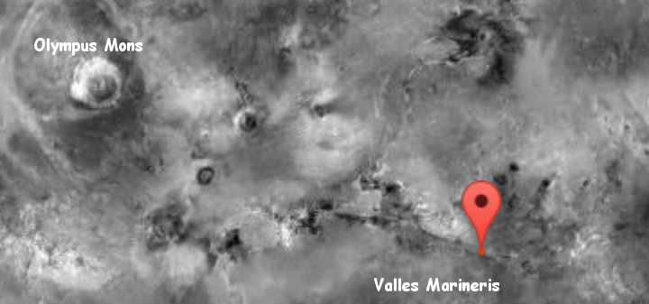
This was essentially our first good look at Mars, taken from orbit by Mariner 9 in 1971.
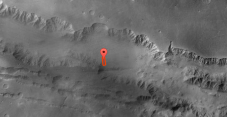
The image to the right is a zoom into one tiny portion of this gigantic canyon, the center trough which has been dubbed Coprates Chasm. From this image we can see that there is a long high elongated mesa running east to west that appears to split the chasm in two. The floor of the chasm itself, north of this mesa, seems almost featureless, as if it was filled with sand. We can see details along the canyon walls, suggesting some form of erosion process that formed the chasm.
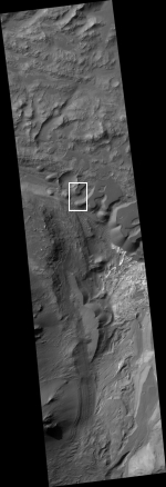
We zoom in further. The image on the right, taken by Mars Reconnaissance Orbiter in March 2012 and significantly reduced to post here, shows us what is inside the red box in the image above. The full resolution version, available here, shows a lot more details, including craters, dunes, cliffs, and all kinds of drainage and wind-blown erosion. Very clearly the floor of Coprates Chasm is not featureless, though it does appear to have trapped a lot of Martian sand over time.
It also appears to have an incredibly complex geological history. The floor of this crater, as shown in this image, does not appear to show any obvious central drainage, as seen in the Grand Canyon for example. There is a hint of one, appearing from the center left, moving through the white box and down to the bottom of the image, though it also appears that many things have changed this drainage (if it was one) since it was first formed.
I should add that Coprates Chasm’s average width is 40 to 60 miles across. This small slice on the right is only about 9 miles long, which means it only sees a small portion of that canyon’s floor. To try to figure out the canyon’s overall formation from this single image is dangerous. More important, we have not zoomed in enough. There are still more details to see as we get closer, looking into the white box of the image on the right..
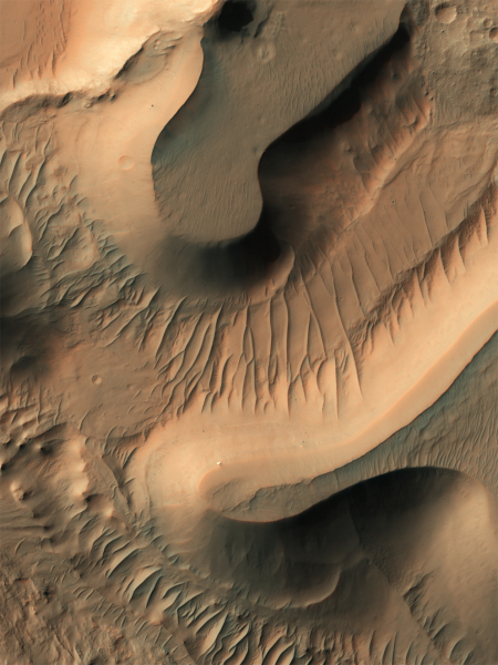
On the left is a reduced resolution version of the Mars Reconnaissance Orbiter image of that white box. From this image we can see that there really does appear to be a lot of sand in this canyon, so much in fact that the mesas in this image appear to almost be entirely formed from that sand. And these mesas are not small. They must be a few hundred feet high. It appears that they have been slowly eroding away, that at one time the top of these two mesas formed the floor of the chasm, and over time sections were eaten away, either by wind erosion or flowing water or glacial ice. If the latter the water and ice is now long gone, at least from the surface. As they admit at the image website,
the exact sequence of events that formed Coprates Chasma is unknown, the ripples, mesas, and craters visible throughout the terrain point to a complex history involving multiple mechanisms of erosion and deposition.
Even at this scale, we haven’t zoomed in enough.
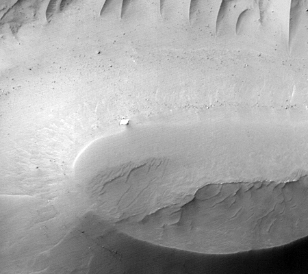
The last image of this series on the left shows the top of the thin bottom mesa, cropped from the full image. Here we can see boulders at the mesa’s base, as well as some form of erosional features on its walls. Near the top of the mesa that white spot in the previous image resolves into what looks like a block of bedrock sticking out from the sand, though it could also be a boulder simply sitting on top of the sand.
There are many mysteries here, but even at this scale we are too far away to really decipher them. To understand the planetary history of this canyon, we will need to walk this particular surface extensively. We will also need to dig down into it. And we will need to walk not just here, but the entire canyon floor, its walls, the surrounding terrain, the nearby giant volcanoes, and in fact all of Mars.
Think about that. The future generations that will first walk on this surface will have an endless adventure, as the amount of untouched terrain before them to explore truly is endless.
On Christmas Eve 1968 three Americans became the first humans to visit another world. What they did to celebrate was unexpected and profound, and will be remembered throughout all human history. Genesis: the Story of Apollo 8, Robert Zimmerman's classic history of humanity's first journey to another world, tells that story, and it is now available as both an ebook and an audiobook, both with a foreword by Valerie Anders and a new introduction by Robert Zimmerman.
The print edition can be purchased at Amazon or from any other book seller. If you want an autographed copy the price is $60 for the hardback and $45 for the paperback, plus $8 shipping for each. Go here for purchasing details. The ebook is available everywhere for $5.99 (before discount) at amazon, or direct from my ebook publisher, ebookit. If you buy it from ebookit you don't support the big tech companies and the author gets a bigger cut much sooner.
The audiobook is also available at all these vendors, and is also free with a 30-day trial membership to Audible.
"Not simply about one mission, [Genesis] is also the history of America's quest for the moon... Zimmerman has done a masterful job of tying disparate events together into a solid account of one of America's greatest human triumphs."--San Antonio Express-News


People want to colonize Mars but we haven’t even begun the serious prospecting needed to choose a suitable site. Such a task will require telerobotics within the cognitive horizon, people on the surface, a supporting presence in local space, and a significant amount of time.
Musk has cancelled his plans to land on Mars surface. He should replace that plan with one that puts humans in Mars’ orbit to control a fleet of robots on the surface.
Indeed, Mars is a proper planet with climate zones and seasons. It lacks tectonics to build mountain chains, but the wind and dust and erosion from temperature variations are powerful sculptors too. And at every place different. This site shows stunning Mars photos. Aerial images even of Earth are tricky to interpret. “Dome dunes”.
http://cosmicdiary.org/
@wodun
I doubt Musk has canceled his plans to land on Mars.
The best way to explore Mars is to send the first crew to Mars’ both moons, while the landing and surface equipment is being developed. Mars’ moons are near microgravity environments and we have lots and lots of experience with that from the space stations and shuttles, so there’s no serious new challenge involved.
The moons are scientifically extremely interesting. Whether they formed together with Mars or are captured asteroids, it would mature technologies for exploring and exploiting asteroids. Compare current asteroid sample return missions with having six astronauts there for a year!
Phobos is so close to Mars that it might work as a gateway (a REAL gateway) between the half year transfer to/from Earth (in big spacecraft), and the landing/ascent maneuver (in minimal spacecraft). One could do this with a free floating Martian space station too, but if there are resources on Phobos maybe it and its physical radiation protection can be helpful.