Near the Martian shoreline
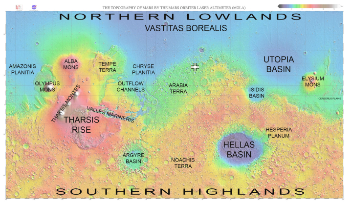
One of the prime areas of research for Mars planetary geologists is the region on Mars where the geography appears to transition from the southern cratered, rough terrain to the northern low, generally smooth, and flat plains. It is theorized by some scientists that the northern plains were once an ocean, probably shallow and probably intermittent, but wet nonetheless for considerable periods. The global map of Mars below, created by the laser altimeter on Mars Global Surveyor, clearly shows the obvious elevation differences between the low northern plans (blue) and the high, more cratered southern regions (changing from yellow to orange as you move higher).

Scientists have spent a considerable effort studying this transition zone (green on the map), illustrated by just one example I recently highlighted, showing that, though there does not appear to be a clear shoreline in many places, there is strong evidence that a shallow ocean repeatedly rose and fell in this transition zone, leaving behind geological ripple marks vaguely reminiscent of those seen on a beach caused by the rise and fall of the tides.
Today we highlight another example, taken in January 2018 at the location indicated by the cross on the above map.
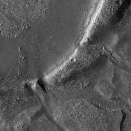
The image was taken by the high resolution camera on Mars Reconnaissance Orbiter and released this week by the spacecraft’s science team. It focuses on an unnamed crater located in Arabia Terra, one of the transition zone’s largest regions. To the right is a reduced resolution crop of the most interesting part of that image, focusing in on the three flow channels that have cut through the crater’s rim to allow some past flow of liquid to continue onward to the south. The crater floor is on the upper left. As noted at the link,
The crater has been filled by sediments and may have been an ancient lake. When the water began to overtop the crater rim, it would rapidly erode a channel and, at least, partially drain the lake.
If you click on the image you can see the full resolution version of the entire crater. Do it. There is lots of interesting features to look at.
There are several take-aways from this image. First, it appears the flow reshaped the entire crater floor. You can see the flow-marks in the sediments there, working southward to the gaps in the crater’s rim. If you look at the full resolution image you can see that the sediments across the entire crater floor appear to have flowed southward toward the gaps. This suggests, as the scientists noted, that the drainage in the crater was somewhat sudden. The crater was a lake filled with water that abruptly pushed through the rim, with the water then quickly draining out.
Second, though the crater is close to the northern edge of the transition zone, it is not at the edge itself, but in the middle of a flat plain, marked green to indicate an elevation about 2 kilometers below what scientists have determined as Mars’s medium zero elevation point. The blue northern plains, where that past ocean is theorized to have existed, are much deeper, at about -4 kilometers. Yet, this crater apparently was able to retain some liquid, suggesting that the water table when the ocean to the north existed was possibly much deeper, as much as 2 kilometers deeper, than presently theorized.
None of this really tells us that much about the theorized oceans of Mars. The image doesn’t tell us how long it existed, or even if it existed intermittently. What this image shows however, along with almost all the images taken of features in the transition zone, is liquid was clearly able to exist on the Martian surface at some time in the past. Images of this transition zone repeatedly show evidence of that liquid ebbing and flowing across the terrain.
Where all that water is now remains the main question. It appears much of it is still there, locked either in an underground frozen water table (labeled an ice table by geologists), or at the poles.
The goal for future colonists will be to find the places where it will be most easily accessible.
On Christmas Eve 1968 three Americans became the first humans to visit another world. What they did to celebrate was unexpected and profound, and will be remembered throughout all human history. Genesis: the Story of Apollo 8, Robert Zimmerman's classic history of humanity's first journey to another world, tells that story, and it is now available as both an ebook and an audiobook, both with a foreword by Valerie Anders and a new introduction by Robert Zimmerman.
The print edition can be purchased at Amazon or from any other book seller. If you want an autographed copy the price is $60 for the hardback and $45 for the paperback, plus $8 shipping for each. Go here for purchasing details. The ebook is available everywhere for $5.99 (before discount) at amazon, or direct from my ebook publisher, ebookit. If you buy it from ebookit you don't support the big tech companies and the author gets a bigger cut much sooner.
The audiobook is also available at all these vendors, and is also free with a 30-day trial membership to Audible.
"Not simply about one mission, [Genesis] is also the history of America's quest for the moon... Zimmerman has done a masterful job of tying disparate events together into a solid account of one of America's greatest human triumphs."--San Antonio Express-News


This is an unnamed crater. Over a thousand craters on Mars have names. Here is a document that traces the origin of those names.
* [https://archive.org/details/TheEtymologyOfMarsCraterNames_201803 The Origin of Mars Crater Names]