A cliff of ice on Mars
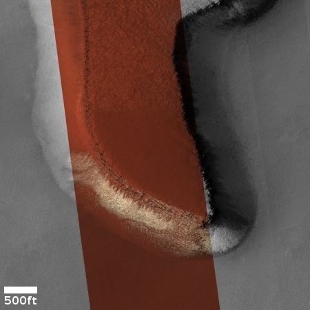
Cool image time! The picture to the right, cropped to post here, was taken on April 10, 2024 by the high resolution camera on Mars Reconnaissance Orbiter (MRO). It shows the southern nose of a large plateau located in the deep south of Mars, at 63 degrees south latitude. This cliff is only about 20-25 feet high, but within that small distance orbital imagery as revealed what appears to be an underground layer of ice. When this photo was released in late June, it came with a short caption, which noted:
On these steep scarps, ice can still be seen on the south facing walls of the scarp towards the end of the Southern Hemisphere’s winter.
Note the white sections on that cliff wall, both inside and outside the color strip. The surrounding orange suggests dust and sand. This photo suggests that during the dark winter underground ice leaches out on these slopes, and is then sublimated away when the Sun returns in the spring. Since the south-facing walls remain in shadow the longest, the ice there lasts the longest, leaving behind these patches we see now.
It is also possible that this is not water ice and there is no underground ice layer. Instead, this might be the last leftover of the dry ice mantle that falls as snow and covers all of the Martian high latitudes during the winter, and then sublimates away come spring.

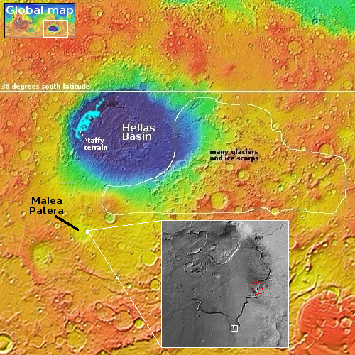
The white dot on the overview map to the right marks the location, inside Malea Patea, believed to be an ancient shield volcano. The inset shows the entire plateau, with the white rectangle marking the area covered by the photo above. The plateau itself is 30 miles wide and 37 miles long. Since the downhill grade is to the south, the plateau itself might be a glacier ice sheet that flowed southward when it was active.
Assuming it has an underground ice layer, that sheet is probably very slowly sublimating away at its southern cliff. This image is likely the start of a project to detect if any changes that might occur over time, as this is the first high resolution MRO image taken here. The research is also probably working to determine if that ice layer exists at all. A second high resolution image of a section of this cliff to the northwest (and indicated by the red rectangle), was also taken on May 29, 2024, allowing more data to be gathered.
It will take many years to find out if any changes are taking place, since the Martian year is twice as long as Earth’s, and it will require imagery across many Martian springs to track any changes.
On Christmas Eve 1968 three Americans became the first humans to visit another world. What they did to celebrate was unexpected and profound, and will be remembered throughout all human history. Genesis: the Story of Apollo 8, Robert Zimmerman's classic history of humanity's first journey to another world, tells that story, and it is now available as both an ebook and an audiobook, both with a foreword by Valerie Anders and a new introduction by Robert Zimmerman.
The print edition can be purchased at Amazon or from any other book seller. If you want an autographed copy the price is $60 for the hardback and $45 for the paperback, plus $8 shipping for each. Go here for purchasing details. The ebook is available everywhere for $5.99 (before discount) at amazon, or direct from my ebook publisher, ebookit. If you buy it from ebookit you don't support the big tech companies and the author gets a bigger cut much sooner.
The audiobook is also available at all these vendors, and is also free with a 30-day trial membership to Audible.
"Not simply about one mission, [Genesis] is also the history of America's quest for the moon... Zimmerman has done a masterful job of tying disparate events together into a solid account of one of America's greatest human triumphs."--San Antonio Express-News
Cool image time! The picture to the right, cropped to post here, was taken on April 10, 2024 by the high resolution camera on Mars Reconnaissance Orbiter (MRO). It shows the southern nose of a large plateau located in the deep south of Mars, at 63 degrees south latitude. This cliff is only about 20-25 feet high, but within that small distance orbital imagery as revealed what appears to be an underground layer of ice. When this photo was released in late June, it came with a short caption, which noted:
On these steep scarps, ice can still be seen on the south facing walls of the scarp towards the end of the Southern Hemisphere’s winter.
Note the white sections on that cliff wall, both inside and outside the color strip. The surrounding orange suggests dust and sand. This photo suggests that during the dark winter underground ice leaches out on these slopes, and is then sublimated away when the Sun returns in the spring. Since the south-facing walls remain in shadow the longest, the ice there lasts the longest, leaving behind these patches we see now.
It is also possible that this is not water ice and there is no underground ice layer. Instead, this might be the last leftover of the dry ice mantle that falls as snow and covers all of the Martian high latitudes during the winter, and then sublimates away come spring.

The white dot on the overview map to the right marks the location, inside Malea Patea, believed to be an ancient shield volcano. The inset shows the entire plateau, with the white rectangle marking the area covered by the photo above. The plateau itself is 30 miles wide and 37 miles long. Since the downhill grade is to the south, the plateau itself might be a glacier ice sheet that flowed southward when it was active.
Assuming it has an underground ice layer, that sheet is probably very slowly sublimating away at its southern cliff. This image is likely the start of a project to detect if any changes that might occur over time, as this is the first high resolution MRO image taken here. The research is also probably working to determine if that ice layer exists at all. A second high resolution image of a section of this cliff to the northwest (and indicated by the red rectangle), was also taken on May 29, 2024, allowing more data to be gathered.
It will take many years to find out if any changes are taking place, since the Martian year is twice as long as Earth’s, and it will require imagery across many Martian springs to track any changes.
On Christmas Eve 1968 three Americans became the first humans to visit another world. What they did to celebrate was unexpected and profound, and will be remembered throughout all human history. Genesis: the Story of Apollo 8, Robert Zimmerman's classic history of humanity's first journey to another world, tells that story, and it is now available as both an ebook and an audiobook, both with a foreword by Valerie Anders and a new introduction by Robert Zimmerman.
The print edition can be purchased at Amazon or from any other book seller. If you want an autographed copy the price is $60 for the hardback and $45 for the paperback, plus $8 shipping for each. Go here for purchasing details. The ebook is available everywhere for $5.99 (before discount) at amazon, or direct from my ebook publisher, ebookit. If you buy it from ebookit you don't support the big tech companies and the author gets a bigger cut much sooner.
The audiobook is also available at all these vendors, and is also free with a 30-day trial membership to Audible.
"Not simply about one mission, [Genesis] is also the history of America's quest for the moon... Zimmerman has done a masterful job of tying disparate events together into a solid account of one of America's greatest human triumphs."--San Antonio Express-News


