Monitoring gullies on Mars for changes

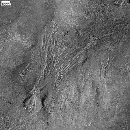
Cool image time! The picture to the right, cropped, reduced, and enhanced to post here, was taken on June 29, 2024 by the high resolution camera on Mars Reconnaissance Orbiter (MRO). The scientists label the picture simply as “gully monitoring,” with an apparent goal of looking to see if this gully has changed since MRO took the first high resolution image two years previously. In the interim this terrain went from Martian spring, through summer and winter, and has now returned to spring.
As far as I can tell, no changes are visible, but then I am not using the highest resolution data available. Small changes might be detectable in the highest resolution using good detection software. Overall, the gully drops about 3,000 feet.
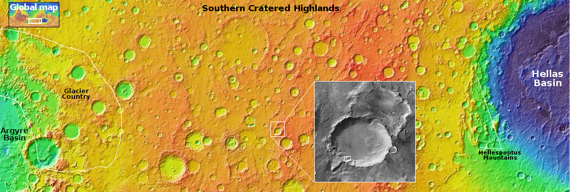
The white dot in the overview map above marks the location, on the southwest interior rim of an unnamed 30-mile wide crater. This region in the Martian cratered highlands was featured in a four part cool image series I did back 2023 (here, here, here, and here), with this as my conclusion:
Overall, our short survey of the southern cratered highlands suggests that the glacial material and ice found in the southern mid-latitudes affects the Martian surface differently than in the northern lowland plains. In the north the craters and the surrounding terrain often appear blobby, as if the ice is close to the surface and also a dominant component of the ground. Impacts therefore cause significant soft melt features, with craters often heavily distorted. Similarly, there is evidence of the existence of past mud volcanoes that once spewed water and mud from below ground.
In the south however the surface is at a higher elevation, and it appears the ice layer is deeper underground. Thus, it appears the ground is more firm, and the only obvious evidence of an underground layer of ice is revealed when sublimation and the subsequent erosion produce these large pits inside craters.
In the case of this crater, a small impact on its interior southwest slope apparently caused that underground layer of ice to melt temporarily and flow downhill, leaving behind the gully and flow features we see today. Based on the two MRO pictures taken a full Martian year apart, it appears the feature is generally stable and thus likely old, left over from that impact. If things are changing seasonally they are doing so in small amounts and slowly.
On Christmas Eve 1968 three Americans became the first humans to visit another world. What they did to celebrate was unexpected and profound, and will be remembered throughout all human history. Genesis: the Story of Apollo 8, Robert Zimmerman's classic history of humanity's first journey to another world, tells that story, and it is now available as both an ebook and an audiobook, both with a foreword by Valerie Anders and a new introduction by Robert Zimmerman.
The print edition can be purchased at Amazon or from any other book seller. If you want an autographed copy the price is $60 for the hardback and $45 for the paperback, plus $8 shipping for each. Go here for purchasing details. The ebook is available everywhere for $5.99 (before discount) at amazon, or direct from my ebook publisher, ebookit. If you buy it from ebookit you don't support the big tech companies and the author gets a bigger cut much sooner.
The audiobook is also available at all these vendors, and is also free with a 30-day trial membership to Audible.
"Not simply about one mission, [Genesis] is also the history of America's quest for the moon... Zimmerman has done a masterful job of tying disparate events together into a solid account of one of America's greatest human triumphs."--San Antonio Express-News


the gully drops about 3,000 feet.
You use this word “gully”. I don’t think it means what you think it means.
For reference, the Grand Canyon averages about twice that. (I looked it up, but an AI answered, so who really knows?)
Mark Sizer: the distance was merely to give a sense of scale. The crater rim itself drops more than 5,000 feet, which is comparable to the hike down from the South Rim of the Grand Canyon.
As for the word “gully,” this is the word the planetary scientists use for these Martian features. They appear to be erosion features, but their origin is not yet completely explained or understood, and might be from many different causes, dependent on latitude, elevation, and the direction the slope faces relative to the Sun.