The icy mesas of Mars’ glacier country

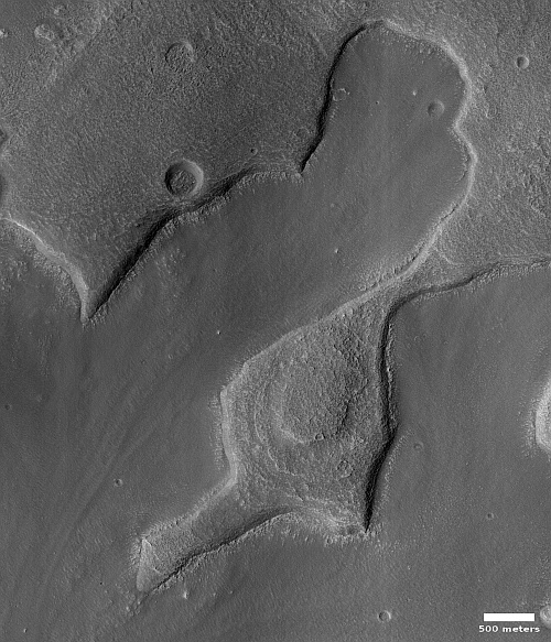
Cool image time! The picture to the right, rotated, cropped, and reduced to post here, was taken on March 25, 2023 by the high resolution camera on Mars Reconnaissance Orbiter (MRO). The science team labeled this image “Cross-Section of Glacier-Like Form,” probably because the mesa in the center of the picture clearly shows numerous layers as you descend from its peak to the surrounding plains, an elevation difference of about 200 feet.
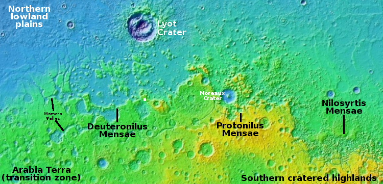
The white dot about 250 miles due south of Lyot Crater on the overview map above marks the location of this mesa, inside the chaos terrain of Deuteronilus Mensae that is the western section of the 2,000 long strip in the northern mid-latitudes of Mars that I call glacier country, since practically every image, like today’s, suggests the presence of glaciers.
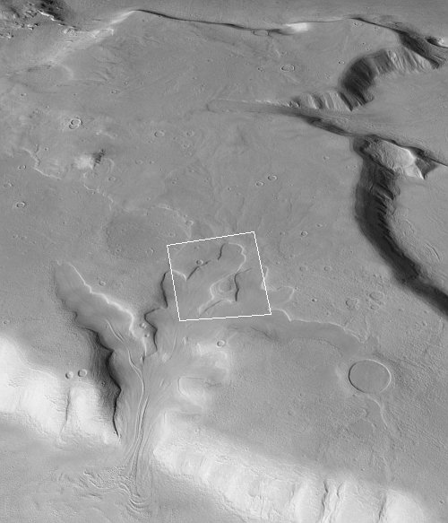
The oblique mosaic below, created using MRO’s context camera images, illustrates this fact even more spectacularly.
The white box on the mosaic to the right marks the area covered by the MRO high resolution image. The elevation drop from this area at the mesa top to the canyon outlet to the south is about 4,300 feet.
The source of this oblique mosaic is a wonderful interactive map created by the Murray Lab at Caltech, using the full dataset of MRO context camera pictures.
The Bruce Murray Laboratory for Planetary Visualization has completed a 5.7 terapixel mosaic of the surface of Mars rendered at 5.0 m/px. Each pixel in the mosaic is about the size of a typical parking space, providing unprecedented resolution of the martian surface at the global scale.
The mosaic covers 99.5% of Mars from 88°S to 88°N. The pixels that make up the mosaic can all be mapped back to their source data, providing full traceability for the entire mosaic. The mosaic is available to stream over the internet and to download, as described below.
Since reader Rex Ridenoure tipped me off about this new tool in April, I have been using this interactive map to determine the precise vertical elevation differences between different objects in MRO pictures, since its creators also tied this map to the full global elevation data gathered by MRO. The map also makes it possible to quickly measure precise distances between points.
Most important however is how it gives one a clear wider view of the Martian terrain. In the picture to the right, the glacial flow down this canyon is obvious and dramatic. In fact, the mosaic suggests that near-surface ice is present everywhere, even on top of the mesa, flowing downhill just like water.
On Christmas Eve 1968 three Americans became the first humans to visit another world. What they did to celebrate was unexpected and profound, and will be remembered throughout all human history. Genesis: the Story of Apollo 8, Robert Zimmerman's classic history of humanity's first journey to another world, tells that story, and it is now available as both an ebook and an audiobook, both with a foreword by Valerie Anders and a new introduction by Robert Zimmerman.
The print edition can be purchased at Amazon or from any other book seller. If you want an autographed copy the price is $60 for the hardback and $45 for the paperback, plus $8 shipping for each. Go here for purchasing details. The ebook is available everywhere for $5.99 (before discount) at amazon, or direct from my ebook publisher, ebookit. If you buy it from ebookit you don't support the big tech companies and the author gets a bigger cut much sooner.
The audiobook is also available at all these vendors, and is also free with a 30-day trial membership to Audible.
"Not simply about one mission, [Genesis] is also the history of America's quest for the moon... Zimmerman has done a masterful job of tying disparate events together into a solid account of one of America's greatest human triumphs."--San Antonio Express-News


