
A global map of rockfalls on the Moon
Click for full resolution image.
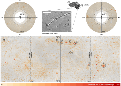
A review of more than two million Lunar Reconnaissance Orbiter (LRO) images of the Moon has allowed scientists to compile the first global map of lunar rockfalls.
The map on the right comes from the paper. From the press release:
The result is a map of the lunar surface between 80 degrees northern and southern latitude that shows 136,610 rockfalls with diameters of more than two and a half meters. “For the first time, this map enables us to systematically analyze the occurrence and causes of rockfalls on another celestial body”, says Dr. Urs Mall from MPS.
Previously, scientists had assumed that lunar quakes in particular were responsible for the displacement of boulders. The new global map of rockfalls indicates that impacts from asteroids may play a much more important role. They are apparently – directly or indirectly – responsible for more than 80 percent of all observed rockfalls.
“Most of the rockfalls are found near crater walls,” says Prof. Dr. Simon Loew of ETH Zurich. Some of the boulders are displaced soon after the impact, others much later. The researchers hypothesize that impacts cause a network of cracks that extend in the underlying bedrock. Parts of the surface can thus become unstable even after very long periods of time.
Though the map suggests vaguely that these rockfalls are more scattered on the lunar farside and more concentrated in the mid-latitudes on the nearside, I suspect this is likely not so. If it is however it reveals something about the Moon that needs to be explained.