
A new geologic map of one of the Moon’s largest impact basins
Click for original image.
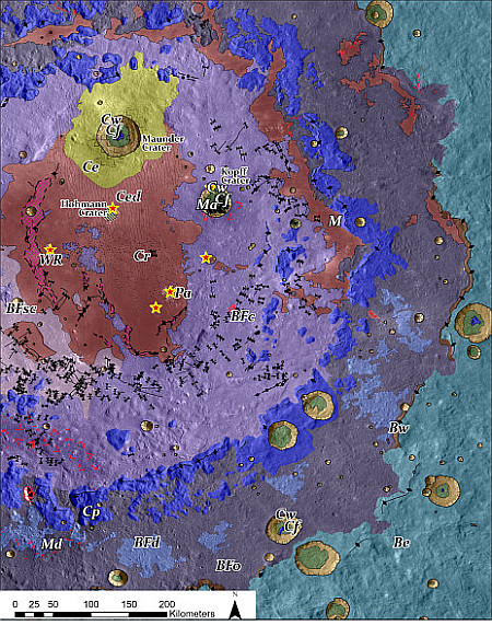
Using data from Lunar Reconnaissance Orbiter (LRO), scientists have now produced a high resolution geological map of Orientale Basin, one of the largest impact basins on the Moon — at about 600 miles across — and located just on the edge of the Moon’s visible near side.
That map is to the right, reduced and sharpened to post here. You can read the paper here [pdf]. From the press release:
Planetary Science Institute Research Scientist Kirby Runyon is a lead author on a paper published in the Planetary Science Journal containing a new high-resolution geologic map of Orientale basin that attempts to identify original basin impact melt. The hope is that future researchers use this map to target sample return missions and pin down impact dates for this and other impact basins.
“We chose to map Oriental basin because it’s simultaneously old and young,” Runyon said. “We think it’s about 3.8 billion years old, which is young enough to still have its impact melt freshly exposed at the surface, yet old enough to have accumulated large impact craters on top of it as well, complicating the picture. We chose to map Orientale to test melt-identification strategies for older, more degraded impact basins whose ages we’d like to know.”
The map’s prime purpose is to pin down locations where material from the actual impact exist and can be returned to Earth for precise dating, thus helping to create a more accurate timeline of the Moon’s formation as well as the entire solar system’s accretion rate.

Click for original image.
Using data from Lunar Reconnaissance Orbiter (LRO), scientists have now produced a high resolution geological map of Orientale Basin, one of the largest impact basins on the Moon — at about 600 miles across — and located just on the edge of the Moon’s visible near side.
That map is to the right, reduced and sharpened to post here. You can read the paper here [pdf]. From the press release:
Planetary Science Institute Research Scientist Kirby Runyon is a lead author on a paper published in the Planetary Science Journal containing a new high-resolution geologic map of Orientale basin that attempts to identify original basin impact melt. The hope is that future researchers use this map to target sample return missions and pin down impact dates for this and other impact basins.
“We chose to map Oriental basin because it’s simultaneously old and young,” Runyon said. “We think it’s about 3.8 billion years old, which is young enough to still have its impact melt freshly exposed at the surface, yet old enough to have accumulated large impact craters on top of it as well, complicating the picture. We chose to map Orientale to test melt-identification strategies for older, more degraded impact basins whose ages we’d like to know.”
The map’s prime purpose is to pin down locations where material from the actual impact exist and can be returned to Earth for precise dating, thus helping to create a more accurate timeline of the Moon’s formation as well as the entire solar system’s accretion rate.