Aram Chaos: Illustrating the puzzle of Mars
The geological history of Mars is incredibly complex, and we really don’t know much about it. What we do know right now is based on a limited number of tiny fragments of a much larger story, with those fragments allowing scientists to only make educated guesses on how they fit together.
Many of those guesses will certainly turn out right. Just as many will turn out wrong. At this moment in our exploration of the Red Planet we can only grasp at straws while always keeping an open mind, as later data is surely going to change any conclusions we presently have.
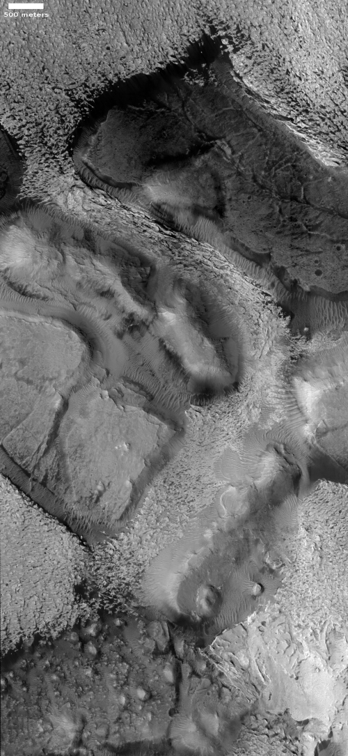
The photo to the right is a good illustration of this struggle. Rotated, cropped, and reduced to post here, it was taken on September 27, 2020 by the high resolution camera on Mars Reconnaissance Orbiter (MRO), and shows what at first glance looks like a stream of white frost or ice descending down a canyon to the south.
That first impression however is entirely wrong. When I asked Chris Okubo of the U.S. Geological Survey, who requested this image from MRO, what it was, he explained,
The white material is not frost. Instead, these are sedimentary rocks comprised primarily of sulfates. The texture to me suggests these are lithified dunes.
Lithified merely means that the dunes have hardened into rock. Sulfates are a salt formed from sulfuric acid, and are on Mars often linked to some complex mineralogy. If you stood there the colors would be white and red, quite beautiful. As Okubo explained,
The sulfates are white to tan in color, but there would also be a lot of red/brown Mars dust on top of it. It would be similar to walking around some of the playas in the desert southwest.
Though these white sulfate deposits have their root in sulfuric acid, Okubo added that they “are in the form of minerals similar to gypsum and so they would be safe to touch.”
What is going on here? As is usually the case, we need to first take a wider view to get some context.


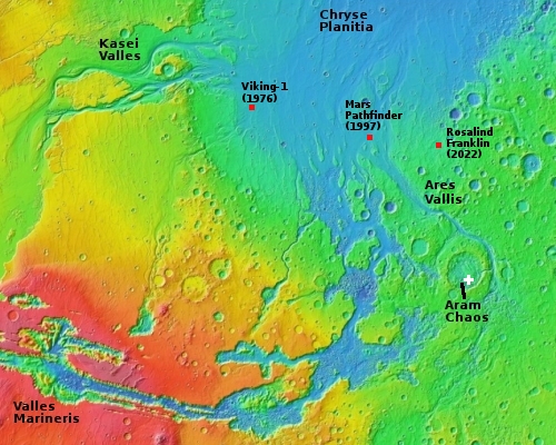
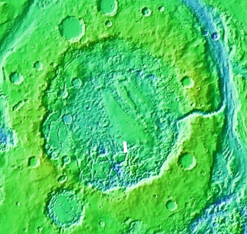
The first overview map to the right shows the location of today’s image by the white cross. The second overview map focuses in on the very eroded and ancient 170-mile wide impact crater dubbed Aram Chaos that this image is within, and that apparently existed prior to the drainage events that created the giant canyons Valles Marineris, Kasei Valles, and Ares Vallis. Ares Vallis especially illustrates this, as it goes around the crater’s faint rim.
In fact, Aram Chaos could even be called a very very large pedestal crater, as it seems to sit higher than the surrounding terrain, which also suggests it was formed first. The impact compressed the material in the crater, so that the surrounding terrain was more easily eroded, eventually leaving Aram Chaos as a kind of plateau.
The floor of Aram Chaos is a place of great puzzlement to planetary geologists. The geology there is incredibly complex, and includes chaos terrain overlain by several sedimentary layers of sulfate minerals. The chaos terrain is most obvious in the southern part of the crater’s floor. The flat areas near the eastern center are those overlaying sedimentary layers.
Untangling the geological history of this terrain would be difficult even if the scientists could wander the countryside and collect endless data and samples from every point. Doing this from Earth, using only a handful of instruments looking down from orbit, makes if far more challenging. You can get a sense of this by reading the abstract from this 2010 paper, which by the way makes a reasonable effort at interpreting the available data:
Sedimentary deposits within the 280 km wide crater containing Aram Chaos have been differentially eroded by wind to expose a stratigraphic column 900–1000 m thick that unconformably overlies the chaos bedrock.
…Two sedimentary units overlie the basement chaos material representing the original plains fill in Aram Crater: the first and oldest is composed of [three layers] (1) a 50–75 m thick dark‐toned basal unit containing ferric hydroxysulfate intercalated with monohydrated‐sulfate‐bearing materials, (2) a 75–100 m thick light‐toned unit with monohydrated sulfates, and (3) a 175–350 m thick light‐toned resistant capping unit with nanophase ferric oxides and monohydrated sulfates.
After a period of wind erosion, these deposits were partially and unconformably covered by the second sedimentary unit, a 75–100 m thick, discontinuous dark‐toned unit containing crystalline hematite and polyhydrated sulfate material. These sedimentary deposits were formed by evaporite deposition during at least two distinct rising groundwater episodes fed by regional‐scale recharge. Later groundwater event(s) formed the polyhydrated materials, indicating that environmental conditions changed to a higher water‐to‐rock ratio. Wind has continued to shape the landscape after the last wetting event to produce the features and exposures observed.
So, here’s the guessed history in plain English. The impact occurs, creating a denser compressed bedrock. That material over time is eroded by some form of water erosion, presently believed to be catastrophic floods, that carved out the chaos terrain of mesas and intersecting canyons along fault lines.
Later events involving lake water inside the crater sequentially create the three mineral beds in the bottom sedimentary layer. This is then followed by a dry period where winds erode those three layers.
Next the crater gets filled with water again, and a new layer of different minerals is laid on top, formed during several periods when that water is evaporating away. Once dry, the prevailing northwest-to-southeast winds carve away at everything, eventually giving us what we see today.
Those prevailing winds kind of explain the river-like appearance of the lithified dunes in the canyon in the above picture. They blew the material down into the canyon, which had been formed by water in the past.
Sounds good? Sure, but please don’t put any money on it as the right explanation of this geological history. The data is still too tenuous. For one thing, we do not have firm dates on anything. For another, no one has yet created a model where the climate on Mars could have ever allowed liquid water on its surface. While the limited data we do have tells us that liquid water must have existed on the surface, that limited data also tells us that liquid water could not have existed on the surface.
We don’t yet know enough to resolve this paradox.
The floor of Aram Chaos is one of the best places I’ve yet seen on Mars to illustrate the limits of our knowledge. The complexity of its geology makes understanding difficult, and thus requires the gathering of a lot more data. Right now, we just don’t have that data, so confidently untangling this complexity with complete confidence is essentially impossible.
But of course, this challenge is what makes it fun to do. If it were easy, it would be boring, and hardly the adventure it is.
On Christmas Eve 1968 three Americans became the first humans to visit another world. What they did to celebrate was unexpected and profound, and will be remembered throughout all human history. Genesis: the Story of Apollo 8, Robert Zimmerman's classic history of humanity's first journey to another world, tells that story, and it is now available as both an ebook and an audiobook, both with a foreword by Valerie Anders and a new introduction by Robert Zimmerman.
The print edition can be purchased at Amazon or from any other book seller. If you want an autographed copy the price is $60 for the hardback and $45 for the paperback, plus $8 shipping for each. Go here for purchasing details. The ebook is available everywhere for $5.99 (before discount) at amazon, or direct from my ebook publisher, ebookit. If you buy it from ebookit you don't support the big tech companies and the author gets a bigger cut much sooner.
The audiobook is also available at all these vendors, and is also free with a 30-day trial membership to Audible.
"Not simply about one mission, [Genesis] is also the history of America's quest for the moon... Zimmerman has done a masterful job of tying disparate events together into a solid account of one of America's greatest human triumphs."--San Antonio Express-News
The geological history of Mars is incredibly complex, and we really don’t know much about it. What we do know right now is based on a limited number of tiny fragments of a much larger story, with those fragments allowing scientists to only make educated guesses on how they fit together.
Many of those guesses will certainly turn out right. Just as many will turn out wrong. At this moment in our exploration of the Red Planet we can only grasp at straws while always keeping an open mind, as later data is surely going to change any conclusions we presently have.
The photo to the right is a good illustration of this struggle. Rotated, cropped, and reduced to post here, it was taken on September 27, 2020 by the high resolution camera on Mars Reconnaissance Orbiter (MRO), and shows what at first glance looks like a stream of white frost or ice descending down a canyon to the south.
That first impression however is entirely wrong. When I asked Chris Okubo of the U.S. Geological Survey, who requested this image from MRO, what it was, he explained,
The white material is not frost. Instead, these are sedimentary rocks comprised primarily of sulfates. The texture to me suggests these are lithified dunes.
Lithified merely means that the dunes have hardened into rock. Sulfates are a salt formed from sulfuric acid, and are on Mars often linked to some complex mineralogy. If you stood there the colors would be white and red, quite beautiful. As Okubo explained,
The sulfates are white to tan in color, but there would also be a lot of red/brown Mars dust on top of it. It would be similar to walking around some of the playas in the desert southwest.
Though these white sulfate deposits have their root in sulfuric acid, Okubo added that they “are in the form of minerals similar to gypsum and so they would be safe to touch.”
What is going on here? As is usually the case, we need to first take a wider view to get some context.


The first overview map to the right shows the location of today’s image by the white cross. The second overview map focuses in on the very eroded and ancient 170-mile wide impact crater dubbed Aram Chaos that this image is within, and that apparently existed prior to the drainage events that created the giant canyons Valles Marineris, Kasei Valles, and Ares Vallis. Ares Vallis especially illustrates this, as it goes around the crater’s faint rim.
In fact, Aram Chaos could even be called a very very large pedestal crater, as it seems to sit higher than the surrounding terrain, which also suggests it was formed first. The impact compressed the material in the crater, so that the surrounding terrain was more easily eroded, eventually leaving Aram Chaos as a kind of plateau.
The floor of Aram Chaos is a place of great puzzlement to planetary geologists. The geology there is incredibly complex, and includes chaos terrain overlain by several sedimentary layers of sulfate minerals. The chaos terrain is most obvious in the southern part of the crater’s floor. The flat areas near the eastern center are those overlaying sedimentary layers.
Untangling the geological history of this terrain would be difficult even if the scientists could wander the countryside and collect endless data and samples from every point. Doing this from Earth, using only a handful of instruments looking down from orbit, makes if far more challenging. You can get a sense of this by reading the abstract from this 2010 paper, which by the way makes a reasonable effort at interpreting the available data:
Sedimentary deposits within the 280 km wide crater containing Aram Chaos have been differentially eroded by wind to expose a stratigraphic column 900–1000 m thick that unconformably overlies the chaos bedrock.
…Two sedimentary units overlie the basement chaos material representing the original plains fill in Aram Crater: the first and oldest is composed of [three layers] (1) a 50–75 m thick dark‐toned basal unit containing ferric hydroxysulfate intercalated with monohydrated‐sulfate‐bearing materials, (2) a 75–100 m thick light‐toned unit with monohydrated sulfates, and (3) a 175–350 m thick light‐toned resistant capping unit with nanophase ferric oxides and monohydrated sulfates.
After a period of wind erosion, these deposits were partially and unconformably covered by the second sedimentary unit, a 75–100 m thick, discontinuous dark‐toned unit containing crystalline hematite and polyhydrated sulfate material. These sedimentary deposits were formed by evaporite deposition during at least two distinct rising groundwater episodes fed by regional‐scale recharge. Later groundwater event(s) formed the polyhydrated materials, indicating that environmental conditions changed to a higher water‐to‐rock ratio. Wind has continued to shape the landscape after the last wetting event to produce the features and exposures observed.
So, here’s the guessed history in plain English. The impact occurs, creating a denser compressed bedrock. That material over time is eroded by some form of water erosion, presently believed to be catastrophic floods, that carved out the chaos terrain of mesas and intersecting canyons along fault lines.
Later events involving lake water inside the crater sequentially create the three mineral beds in the bottom sedimentary layer. This is then followed by a dry period where winds erode those three layers.
Next the crater gets filled with water again, and a new layer of different minerals is laid on top, formed during several periods when that water is evaporating away. Once dry, the prevailing northwest-to-southeast winds carve away at everything, eventually giving us what we see today.
Those prevailing winds kind of explain the river-like appearance of the lithified dunes in the canyon in the above picture. They blew the material down into the canyon, which had been formed by water in the past.
Sounds good? Sure, but please don’t put any money on it as the right explanation of this geological history. The data is still too tenuous. For one thing, we do not have firm dates on anything. For another, no one has yet created a model where the climate on Mars could have ever allowed liquid water on its surface. While the limited data we do have tells us that liquid water must have existed on the surface, that limited data also tells us that liquid water could not have existed on the surface.
We don’t yet know enough to resolve this paradox.
The floor of Aram Chaos is one of the best places I’ve yet seen on Mars to illustrate the limits of our knowledge. The complexity of its geology makes understanding difficult, and thus requires the gathering of a lot more data. Right now, we just don’t have that data, so confidently untangling this complexity with complete confidence is essentially impossible.
But of course, this challenge is what makes it fun to do. If it were easy, it would be boring, and hardly the adventure it is.
On Christmas Eve 1968 three Americans became the first humans to visit another world. What they did to celebrate was unexpected and profound, and will be remembered throughout all human history. Genesis: the Story of Apollo 8, Robert Zimmerman's classic history of humanity's first journey to another world, tells that story, and it is now available as both an ebook and an audiobook, both with a foreword by Valerie Anders and a new introduction by Robert Zimmerman.
The print edition can be purchased at Amazon or from any other book seller. If you want an autographed copy the price is $60 for the hardback and $45 for the paperback, plus $8 shipping for each. Go here for purchasing details. The ebook is available everywhere for $5.99 (before discount) at amazon, or direct from my ebook publisher, ebookit. If you buy it from ebookit you don't support the big tech companies and the author gets a bigger cut much sooner.
The audiobook is also available at all these vendors, and is also free with a 30-day trial membership to Audible.
"Not simply about one mission, [Genesis] is also the history of America's quest for the moon... Zimmerman has done a masterful job of tying disparate events together into a solid account of one of America's greatest human triumphs."--San Antonio Express-News


