
Miranda, the smallest of Uranus’ spherical moons
Click for original image.
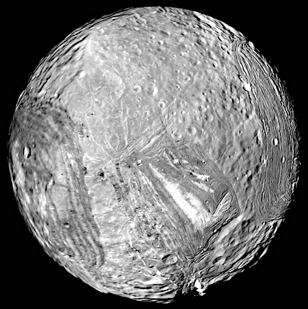
Cool image time! The image to the right, reduced and sharpened to post here, was created from photographs taken on January 24, 1986 by Voyager-2 as it made its fly-by of the gas giant Uranus. From a later 1996 release:
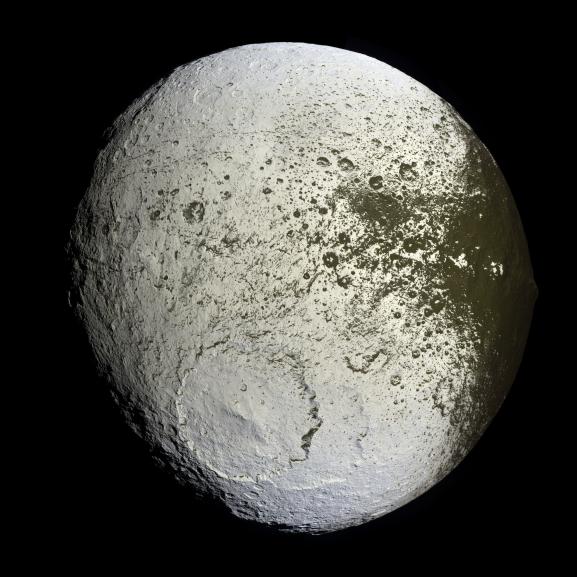
Miranda, roughly 300 miles in diameter, exhibits varied geologic provinces, seen in this mosaic of clear-filter, narrow-angle images from Jan. 24, 1986. The images were obtained from distances of 18,730 to 25,030 miles; resolution ranges from 1,840 to 2,430 feet. These are among the highest-resolution pictures that Voyager has obtained of any of the new “worlds” it has encountered during its mission.
On Miranda, ridges and valleys of one province are cut off against the boundary of the next province. Probable compressional (pushed-together) folded ridges are seen in curvilinear patterns, as are many extensional (pulled-apart) faults. Some of these show very large scarps, or cliffs, ranging from 1,600 feet to 3 miles in height — that is, higher that the walls of the Grand Canyon on Earth.
This is really the only close look we have of this distant world. The other hemisphere remains a mystery, as it was in darkness when Voyager-2 zipped past. And though some of the individual shots that make up this mosiac are more detailed, they don’t provide that much more information.
Nonetheless, to my uneducated eye Miranda looks like a ball of thick molasses that some giant stirred a bit as gravity forced it to settle into its spherical shape. In this case the molasses is likely a mix of ice and other materials, not yet fully identified. The result is a tiny misshapen planet with some of the roughest topography known in the solar system, including one 12-mile high cliff face (the white streak at the image bottom) thought to be the highest in the solar system.
We don’t yet have a true understanding of the geological processes that formed this strange landscape, nor will we have until we have a lot more data, including a global map of the entire surface. And that won’t come until a spacecraft is sent there to look more closely. Right now no such mission is in the works. No NASA missions have been funded, though several have been proposed. And a Chinese mission was apparently canceled last year.

Click for original image.
Cool image time! The image to the right, reduced and sharpened to post here, was created from photographs taken on January 24, 1986 by Voyager-2 as it made its fly-by of the gas giant Uranus. From a later 1996 release:
Miranda, roughly 300 miles in diameter, exhibits varied geologic provinces, seen in this mosaic of clear-filter, narrow-angle images from Jan. 24, 1986. The images were obtained from distances of 18,730 to 25,030 miles; resolution ranges from 1,840 to 2,430 feet. These are among the highest-resolution pictures that Voyager has obtained of any of the new “worlds” it has encountered during its mission.
On Miranda, ridges and valleys of one province are cut off against the boundary of the next province. Probable compressional (pushed-together) folded ridges are seen in curvilinear patterns, as are many extensional (pulled-apart) faults. Some of these show very large scarps, or cliffs, ranging from 1,600 feet to 3 miles in height — that is, higher that the walls of the Grand Canyon on Earth.
This is really the only close look we have of this distant world. The other hemisphere remains a mystery, as it was in darkness when Voyager-2 zipped past. And though some of the individual shots that make up this mosiac are more detailed, they don’t provide that much more information.
Nonetheless, to my uneducated eye Miranda looks like a ball of thick molasses that some giant stirred a bit as gravity forced it to settle into its spherical shape. In this case the molasses is likely a mix of ice and other materials, not yet fully identified. The result is a tiny misshapen planet with some of the roughest topography known in the solar system, including one 12-mile high cliff face (the white streak at the image bottom) thought to be the highest in the solar system.
We don’t yet have a true understanding of the geological processes that formed this strange landscape, nor will we have until we have a lot more data, including a global map of the entire surface. And that won’t come until a spacecraft is sent there to look more closely. Right now no such mission is in the works. No NASA missions have been funded, though several have been proposed. And a Chinese mission was apparently canceled last year.


