
Chaos on Mars
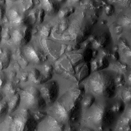
Cool image time! The image on the right, cropped and reduced in resolution to post here, shows an area on Mars that geologists have dubbed “Chaos Terrain.” If you click on the image you can see the full image, which also includes several canyons oriented in what seem to be random directions.
I first heard this geological term for regions on Mars shortly after the first orbital missions circling Mars began taking images back in the 1970s. It applied to places where the terrain was hummocky, a crazy collection of hills forming no pattern at all. Earth does not really have such terrain.
The close-up to the right also shows that at least one of these hills is fractured, made up of several large pieces that have separated over time.
This image was part of the May 2nd image release from the high resolution camera on Mars Reconnaissance Orbiter. What makes it interesting is its location on Mars. The image below shows that location, indicated by a white cross.
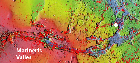
This chaotic terrain is located at the mouth of the solar system’s largest known canyon, Marineris Valles. It was here that scientists believe the water from that canyon catastrophically flooded outward into Mars’s northern flat plains, where a shallow intermittent ocean might have once existed.
If we zoom in on the overview map, we find that the entire mouth of this outlet valley is filled with this chaos terrain.
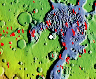
The image on the right shows this. What we find is that the chaos terrain highlighted above is actually located in a small side pocket hollow that is off the main drainage path from Marineris Valles. In this side hollow it appears that the flows came not from the main canyon to the northeast, but off the plateau above to the south and west. A look at the google context image at the bottom of the image page shows this clearly. The flow pattern appears to go from the high southwest plateau down through this hollow and out to the northeast.
My first thought in looking at this image and its overall context is that during the catastrophic floods, this side hollow was the location of an eddy, and was also a confluence from two drainages, first from the plateau and second from Marineris Valles. At that meeting point the waters raged, tearing into the ground to produce the chaos terrain we see now.
Or not. The geology here is very complex, and trying to guess its origins from these orbital images is very dangerous. First impressions in science are quite often wrong. A closer look will be necessary to untangle this geology, but that closer look will be significant as it will likely give us the geological history of Marineris Valles, which because it is such an important and dominate feature on Mars will probably also define much of the geological history of the entire planet. Did a catastrophic flood occur? Was there an ocean in Mars’s northern plains? And did liquid water once flow on Mars, and if so, how was it possible given what we know of the planet’s thin atmosphere?
All tantalizing questions. All crucial for understanding the formation and geology of Mars, the only full-sized terrestrial planet in the solar system that we have any chance of settling in the near future.

On Christmas Eve 1968 three Americans became the first humans to visit another world. What they did to celebrate was unexpected and profound, and will be remembered throughout all human history. Genesis: the Story of Apollo 8, Robert Zimmerman's classic history of humanity's first journey to another world, tells that story, and it is now available as both an ebook and an audiobook, both with a foreword by Valerie Anders and a new introduction by Robert Zimmerman.
The print edition can be purchased at Amazon or from any other book seller. If you want an autographed copy the price is $60 for the hardback and $45 for the paperback, plus $8 shipping for each. Go here for purchasing details. The ebook is available everywhere for $5.99 (before discount) at amazon, or direct from my ebook publisher, ebookit. If you buy it from ebookit you don't support the big tech companies and the author gets a bigger cut much sooner.
The audiobook is also available at all these vendors, and is also free with a 30-day trial membership to Audible.
"Not simply about one mission, [Genesis] is also the history of America's quest for the moon... Zimmerman has done a masterful job of tying disparate events together into a solid account of one of America's greatest human triumphs."--San Antonio Express-News
It would be nice if their was a distance scale on the Mars pics, it’s usually far larger than people would guess.
Orion314: The webpage gives a scale of 50 centimeters per pixel. The full resolution image has 72 pixels per inch, which translates to 3,600 centimeters per inch, which then translates into a scale of about 120 feet per inch.
In my reduced and cropped image, I reduced the size of the cropped section from 1200×1200 pixels to 450×450, a 63% reduction. If my math is right (don’t bet on it!), this would make the scale in my image to be about 320 feet per inch.
I have no faith in these calculations. Someone more skilled in these matters should take a look and tell us what the real scale might be.
Reminds me of old cement that seen a little too much salt and winters. Like Niagara Falls, water? Fell from off the high land and exposed the bed rock. All broken and fractured from a few too many meteor impacts.