
The Martian North Pole
Since the very beginning of telescopic astronomy, the Martian poles have fascinated. Their changing sizes as the seasons progressed suggested to the early astronomers that Mars might be similar to Earth. Since the advent of the space age we have learned that no, Mars is not similar to Earth, and that its poles only resemble Earth’s in a very superficial way.
Yet, understanding the geology and seasonal evolution of the Martian poles is critical to understanding the planet itself.
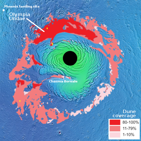
This post will focus on the Martian north pole. The map on the right of the north polar regions is based on many satellite images supplemented by a lot of research by planetary scientists. The black circle in the middle is an area with relatively poor image coverage. The green areas are regions of higher elevation where the bulk of the permanent ice cap is located, surrounded by the blue northern lowlands that cover much of Mars’s northern hemisphere and are thought to have once harbored an intermittent ocean.
Click for full image.
The reddish regions encircling the permanent ice cap are large seas of sand dunes, with Olympia Undae the largest and most sand-dune-packed. The image on the right, posted initially here on March 25, 2016, was taken by Mars Odyssey and shows the endlessness of this dune sea. Olympia Undae, spanning 120 degrees of longitude, is about 700 miles long, making it bigger than the Grand Canyon. As I noted in that post, “Just imagine trying to travel though this area. It is the epitome of a trackless waste. And without some form of GPS system getting lost forever would be incredibly easy.”
The polar cap itself, surrounded by those sand seas, is 600 miles across and a little less than 7,000 feet deep. It is made up of many seasonal layers, like the icecaps on Earth, with the bulk a mixture of water ice and cemented dust and sand. The very top layers, dubbed the residual icecap, is about three to six feet thick made up of frozen water having a volume about half of Greenland’s icecap. While this water could sublimate away, data suggests it is, like the icecaps on Earth, in a steady state, neither gaining or losing volume with each Martian year.
Above the residual icecap of water is the seasonal icecap made up of carbon dioxide. Unlike the other layers, this seasonal cap of dry ice, also less than six feet thick, comes and goes with the seasons. During the Martian summer it is gone, the carbon dioxide having sublimated away into the atmosphere. As the weather chills however that carbon dioxide begins to freeze again, falling as CO2 snow on the surface at the poles to create a thin cap of dry ice extending down to about 60 degrees latitude and covering practically everything seen in the first map above.
These facts suggest that future Martian colonists will have an interest in this region. While harsher than the rest of the planet, the conditions at the poles are not so much different that it will be impossible to work here. And here they will find a ready supply of carbon dioxide to help their plants grow, as well as a ready supply of water, all easily mined and near the surface.
In order to understand how this dry ice cap comes and goes, scientists have been using the high resolution camera of Mars Reconnaissance Orbiter (MRO) to repeatedly monitor some of the same locations in these sand seas to track the seasonal changes. In my routine review of the new images downloaded from MRO in May, I came across more than a dozen such images, all of which had been requested by Dr. Candice Hansen of the Planetary Science Institute in Tucson, Arizona, and taken just as the Martian winter was ending and spring was beginning. As she explained to me, “The images I’m requesting now follow-up on many of our earlier study sites so that we can study interannual variability. We’re also looking at more places to get a sense of what is similar/different depending on where you are.”
Below are two of these recent images, showing one example of the springtime changes that can be seen on these dunes.
Click for full image.
Click for full image.
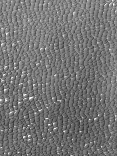
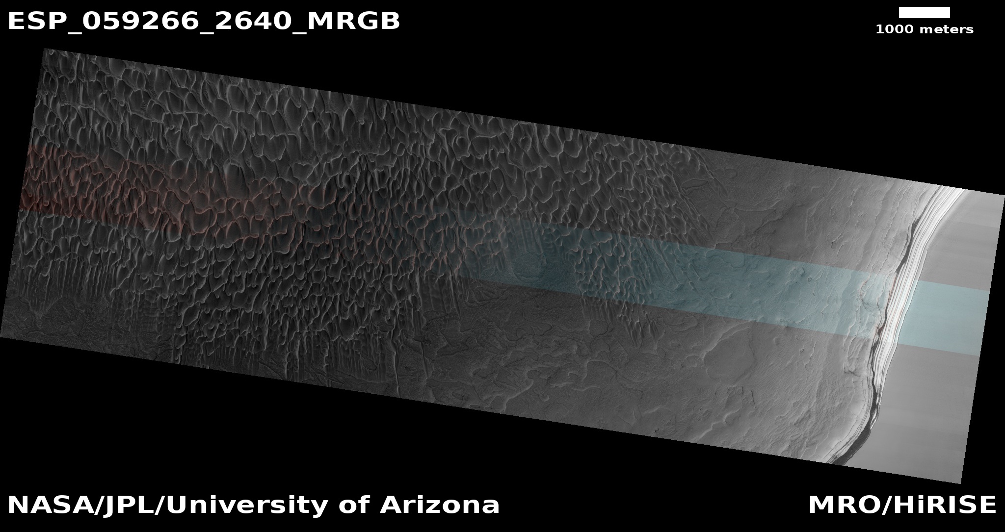
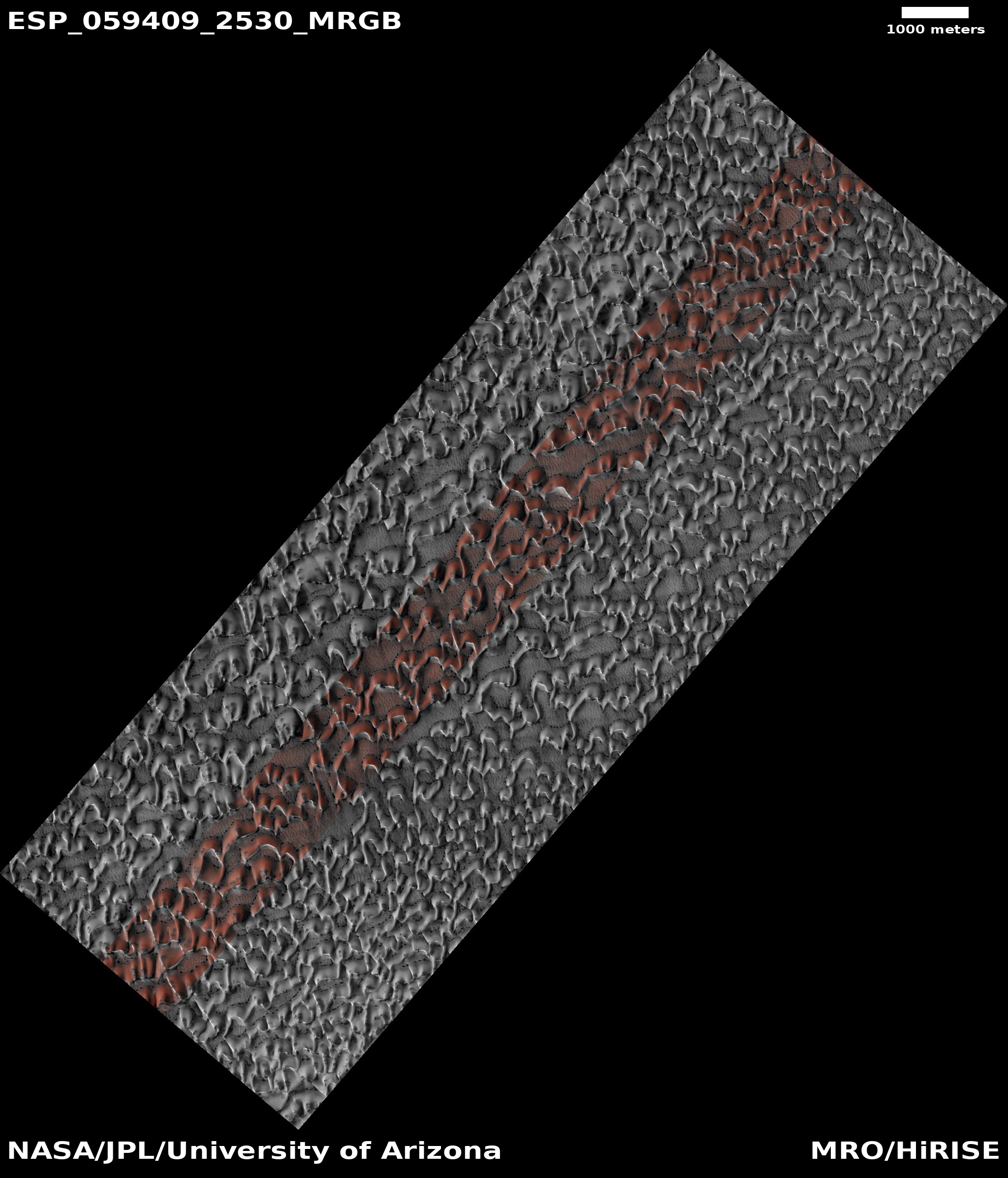
Taken only a little more than two weeks apart by MRO, the two images show the beginnings of the annual sublimation process that results in the disappearance of that entire seasonal cap of dry ice. The location of these dunes, dubbed “Buzzel” by the scientists, is shown on the map above by the tiny yellow rectangle on the northernmost part of Olympia Undae, closest to the pole, and just on the edge of the rising main icecap, indicated in green.
The first picture, taken on March 19, 2019, shows the dunes, as well as the circular ghost of what is likely to be a buried crater, when they are entirely covered with that thin layer of dry ice. At the time this picture was taken winter was just ending.
When the second photograph was taken a few weeks later on April 4, several dark spots have appeared at the base of a number of dunes, signaling the beginning of the sublimation of the dry ice cap.
What scientists believe is happening here is that when winter ends and the sun reappears at this Arctic location, a small percentage of that sunlight, about 10%, goes through the dry ice and warms the sand that the dry ice mantles. This in turn warms the bottom of the dry ice layer, causing this to sublimate into a gas that is now trapped.
When the pressure builds sufficiently, that gas breaks free at the weakest spots in the dry ice layer, which are either at the dune crest or at its base, or sometimes on its face where cracks form. When it does so the CO2 gas carries with it material from below, which appears dark relative to the bright dry ice on the surface. As the summer season progresses and more dry ice sublimates away, the dark smudges disappear as they slowly blend in with the now-exposed original sand surface. The process is now ready to start over and repeat.
Click for full image.
The image to the right was taken by MRO on March 30, 2019, also at the beginning of the sublimation of the dry ice at the beginning of spring. This location, dubbed “Pismo Beach” by the scientists, is indicated on the map above by the tiny yellow rectangle in the lighter pink sand sea to the southwest of the pole. Farther south than the previous location, the sublimation process is therefore farther along, which is why there are so many more black smudges at the bases of the dunes.
This process is believed to be the same process that produces the spider formations in the south pole. In the south the sublimation process that produces the spiders occurs mostly on a permafrost surface, not dunes. With each season this sublimation causes erosion at the exact same locations, thus slowly forming the spider shapes that we see.
At the north pole, however, no spiders form on permafrost, for reasons that are not yet understood. As Hansen explained, “There are a bunch of factors that are different, north and south. We just haven’t honestly had the time to go through the physics of it all and come up with an answer.”
Meanwhile, the sublimation on dunes in the north produces no permanent features, such as spiders, because the dunes evolve and erode over time. Even if sublimation occurs on the same dune crest from year to year, that crest itself changes in the intervening seasons, so that the erosion caused by the sublimation is gone when the next spring arrives.

Click for full image.
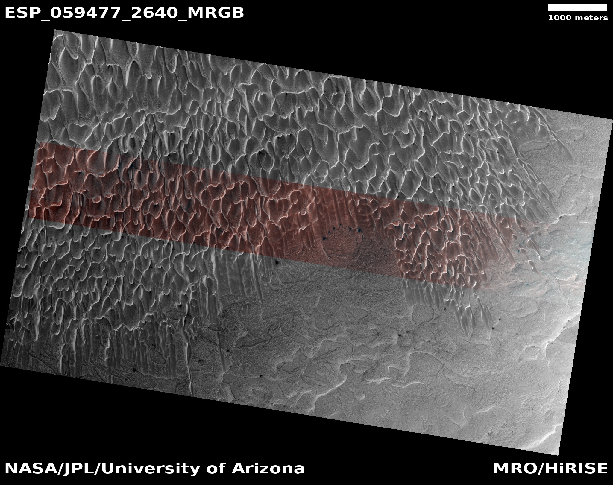
One last image, to the right and cropped to post here, is a place scientists have dubbed “Cool Fans.” Taken by MRO on April 5, 2019, the photograph shows an area deep within Olympia Undae, the location indicated by the northernmost tiny yellow rectangle on the above map.
Here in this gigantic long-lived sand sea, the dunes are tightly packed, with no end in sight in any direction. Like the first Buzzel image above, almost everything you see here is covered by that thin drapery of dry ice. However, the sublimation process has begun, as shown by the dark fanlike smudge near the center of the image.
Though the base of all these dunes is dark, this is not from sublimation, as the sun has not yet reached these low points. Instead, this darkness in the grooves is shadow.
Other images taken by MRO of this region all appear the same. The dunes in Olympia Undae go on and on, one after another, covering all the terrain for as far as the eye can see. This is truly a lifeless desert, though it changes each season with the coming and going of its dry ice drapery.

On Christmas Eve 1968 three Americans became the first humans to visit another world. What they did to celebrate was unexpected and profound, and will be remembered throughout all human history. Genesis: the Story of Apollo 8, Robert Zimmerman's classic history of humanity's first journey to another world, tells that story, and it is now available as both an ebook and an audiobook, both with a foreword by Valerie Anders and a new introduction by Robert Zimmerman.
The print edition can be purchased at Amazon or from any other book seller. If you want an autographed copy the price is $60 for the hardback and $45 for the paperback, plus $8 shipping for each. Go here for purchasing details. The ebook is available everywhere for $5.99 (before discount) at amazon, or direct from my ebook publisher, ebookit. If you buy it from ebookit you don't support the big tech companies and the author gets a bigger cut much sooner.
The audiobook is also available at all these vendors, and is also free with a 30-day trial membership to Audible.
"Not simply about one mission, [Genesis] is also the history of America's quest for the moon... Zimmerman has done a masterful job of tying disparate events together into a solid account of one of America's greatest human triumphs."--San Antonio Express-News
So, no Grand Canal, then…?
Immanuel Velikovsky had a “Hollow Earth” conspiracy theory that used, as one of its “proofs” the lack of map detail on the poles, where supposedly the surfaces of outer and inner Earth connected. That lack of detail “demonstrated” for the conspiracy theorists efforts to cover up the truth! I see that the Martian poles also lack detail.
Coincidence?! I think not.
This leads to the question of whether ALL the planets can be aligned under a conspiracy theory similar to the Hollow Earth.
Neptune, at least, has an interesting hexagonal pole feature to discuss.
Mars is a dead end. Once we get into space, we won’t be going back down any gravity wells, except for the Moon. Mars offers nothing not available on the Moon and/or NEOs.
So, Anon, the Martian “Lost World” may be Barsoom? I so want to meme that…
Anon, how about that?
https://www.metabunk.org/why-do-some-satellites-show-a-hole-at-the-poles-hollow-earth-inclined-orbit.t8109/