
Faults on Mars
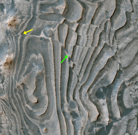
Cool image time! The Mars Reconnaissance Orbiter (MRO) image on the right, reduced in resolution to post here, captures a distinctive fault line that cuts across some layered deposits. As noted by the MRO science team,
Some of the faults produced a clean break along the layers, displacing and offsetting individual beds (yellow arrow).
Interestingly, the layers continue across the fault and appear stretched out (green arrow). These observations suggest that some of the faulting occurred while the layered deposits were still soft and could undergo deformation, whereas other faults formed later when the layers must have been solidified and produced a clean break.
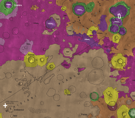
These layers are located in Meridiani Planum, a relatively flat area on the Martian equator. Opportunity landed on this plain to the southwest of this region, as shown on the geology map to the left. The white cross in the southwest corner indicates Opportunity’s landing site, with Endeavour Crater just to the southeast. The white box in the northwest shows where the faulted layered deposits are located. Based on the scale of the map, this places Opportunity approximately 400 miles away.
What exactly caused these distinct faults remains unknown. The likely cause would be a earthquake, but since Mars does not have plate tectonics like the Earth, earthquakes would have to be caused by other geological processes not yet studied.
To my eye, they look like cracks in a mirror, though this provides no real explanation other than it illustrates how cool the image is.

On Christmas Eve 1968 three Americans became the first humans to visit another world. What they did to celebrate was unexpected and profound, and will be remembered throughout all human history. Genesis: the Story of Apollo 8, Robert Zimmerman's classic history of humanity's first journey to another world, tells that story, and it is now available as both an ebook and an audiobook, both with a foreword by Valerie Anders and a new introduction by Robert Zimmerman.
The print edition can be purchased at Amazon or from any other book seller. If you want an autographed copy the price is $60 for the hardback and $45 for the paperback, plus $8 shipping for each. Go here for purchasing details. The ebook is available everywhere for $5.99 (before discount) at amazon, or direct from my ebook publisher, ebookit. If you buy it from ebookit you don't support the big tech companies and the author gets a bigger cut much sooner.
The audiobook is also available at all these vendors, and is also free with a 30-day trial membership to Audible.
"Not simply about one mission, [Genesis] is also the history of America's quest for the moon... Zimmerman has done a masterful job of tying disparate events together into a solid account of one of America's greatest human triumphs."--San Antonio Express-News
Yes cool pics & map. (we truly are, living in the Future!)
forgive my ignorance–
Are there seismographs physically on Mars? And does it have “mars-quakes,” in the absence of plate-tectonic processes?
tangentially–
what is the deepest hole, we have ever physically drilled on the Moon or Mars??
Wayne: As far as I know, we have no seismographs on Mars, and I think never have. As for drill holes, I don’t think anything has gone down more than a foot, and likely less.
Both Viking 1 and Viking 2 had seismometers; Viking 1’s broke on landing and Viking 2’s might have detected one very low intensity event. Maybe. Which means probably not.
The Martian core is no longer liquid enough to spin, which is why Mars lacks a magnetic field. In all probability the core and mantle sufficiently cooled as to make plate tectonic and volcanic activity impossible. Some speculation has it that the Tharsis bulge is due to the last fluidic push of the core as it ceased rotation. This would explain the formation of Arsia, Pavonis and Ascraeus Mons (and tangentially Olympic Mons), the four shield volcanoes associated with Tharsis.
You do not need tectonic activity in order to have localized fault formation. Subsurface rock formations are not solid; they crack and slide against each other due to various forces. I’m certain that Mr. Z has seen such faulting many times in his cave explorations.
In concern to the Martian image above, I would guess that what we are seeing is localized fracturing. The crater containing the linked image appears to have been formed before the one to the south. A newer impact that is this close to an existing crater could easily cause such faulting, that is, if the existing crater bedrock is sufficiently solid to allow such cracking.
Mark: Thank you for the correction and clarification. Most appreciated.
Great comment Mark. Encouraging to me is the activity suggests that concentrated ores are likely to be found on mars due to other earth like geological activities?
Mark – very informative comments – thank you
So what would be the time to see these fault lines start to “fade” due to wind erosion? (Or other force?)
How often would we expect these faults to be shifting? Will they continue to shift?
That whole area seems extremely chaotic. Almost like rotten ice. But it would have to be on an enormous scale. Maybe an ancient ice sheet was here and has since sublimated away. Would be interesting to know what the surface material is. Mudstone?
The small patch of Barchan dunes to the east of the main faulted area is interesting! (Winds from the west-north-west) There is some small scale fracturing around this area too.
The main faulted area looks like it is near the edge of an ancient crater. Might be related…