
A lunar landslide
Click for full image.
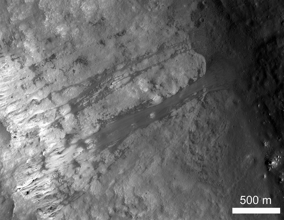
Cool image time! The image to the right was posted by the Lunar Reconnaissance Orbiter (LRO) science team on October 9, 2020, and shows a spectacular landslide almost a mile and a half long that had occurred on the interior rim of a crater on the Moon.
The top of the rim is on the left, with the landslide breaking out onto the floor of the crater on the right.
The walls of Kepler crater (30 kilometer diameter) exhibit numerous landslides. In this example, a landslide of dark material begins about 100 meters below the rim from a narrow box canyon. The box canyon is about 50 meters wide and 300 meters long. Overall, the slide is extends some 2300 meters (from the end of the canyon to its base). The base of the slide is on a fault block that lies some 1800 meters below the rim. The wall slope is about 33 degrees.
This slide is actually composed of a series of narrow landslides 20-30 meters wide. Along most of the slope, the individual slides overrun each other forming a band of debris up to about 180 meters wide. At the base of the slope, the individual slides can be recognized as they move apart forming a fan of material. A few individual isolated slides also occur adjacent to the main mass. The overlapping nature of these small slides indicate that the overall feature may have formed over a period of time, rather than all at once.
From above and at this resolution, the landslide looks almost like frozen flowing liquid. It allso looks like it began with a scattering of boulders breaking free at the top all at once that quickly consolidated into a single massive avalanche.
At the link you can zoom in or out to look at the entire image, at full resolution.

On Christmas Eve 1968 three Americans became the first humans to visit another world. What they did to celebrate was unexpected and profound, and will be remembered throughout all human history. Genesis: the Story of Apollo 8, Robert Zimmerman's classic history of humanity's first journey to another world, tells that story, and it is now available as both an ebook and an audiobook, both with a foreword by Valerie Anders and a new introduction by Robert Zimmerman.
The print edition can be purchased at Amazon or from any other book seller. If you want an autographed copy the price is $60 for the hardback and $45 for the paperback, plus $8 shipping for each. Go here for purchasing details. The ebook is available everywhere for $5.99 (before discount) at amazon, or direct from my ebook publisher, ebookit. If you buy it from ebookit you don't support the big tech companies and the author gets a bigger cut much sooner.
The audiobook is also available at all these vendors, and is also free with a 30-day trial membership to Audible.
"Not simply about one mission, [Genesis] is also the history of America's quest for the moon... Zimmerman has done a masterful job of tying disparate events together into a solid account of one of America's greatest human triumphs."--San Antonio Express-News
OT: Robert, as a spelunker “caveman”, what is known about underground lakes and rivers on/in Earth?
Subsurface lakes and oceans have been proposed on multiple moons and Mars. On Earth I’ve heard of a lake under the ice on the Antarctic continent. How well is the occurrence of subsurface lakes and even rivers known on Earth? Is it hard to figure out, or are there even large regional maps of them?
It’s one thing in mountain chains with glaciers or seasonal snow melt, but I wonder about below the sea level, or even below the sea bottom.
LocalFluff: Be aware that cavers do not use the term “spelunker.” since to us it refers to someone who hasn’t the faintest idea what to do underground and almost always needs rescuing.
On Earth most caves are formed by water flowing underground through limestone. That limestone or karst geology has been well-mapped worldwide (do a search on DuckDuckGo), but on smaller scales is very incomplete. This is one reason why cavers explore, because the discovery of new cave passages helps map the underground drainage in karst terrain, since in that terrain almost no water flows on the surface. It all sinks.
Furthermore, all land masses on Earth have what is called a water table. At a certain depth (which varies) you will always find water underground. This is why people drill shafts for water.
For Mars they have labeled this the ice table, though the two are not entirely comparable.
Pardon my English, caver, it is difficult to distinguish nuances in words I rarely read or use.
So karst is where the water could’ve made clear water reservoirs, or even streams by eroding soft rock (limestone). In contrast to the general water table that just saturates whatever mud or rock is down there?
The large scale world maps of karst geology formations don’t seem to have much relation to what’s on top of them on the surface. There seems to be one such formation beneath the Ural mountains, but nothing beneath the Andes, for example. And no apparent correlation between jungle or desert. Nor with tectonic plate boundaries. Nor with latitude.
Seems hard to figure out where on an exotic place like Titan there is potential for subsurface lakes.
LocalFluff: Yup, limestone or karst terrains do not correlate with mountains or valleys or any topology. They are formed from the sedimentary deposit of sealife underwater, over many eons. When the ocean recedes and the sedimentary layers are later crushed, shifted, deformed, and reshaped, they can be found in almost any terrain.
All that is really required is that at some point in past that karst was once at the bottom of an ocean or sea, for a long enough time to build up layers.