
A Martian polliwog

Click for full image.
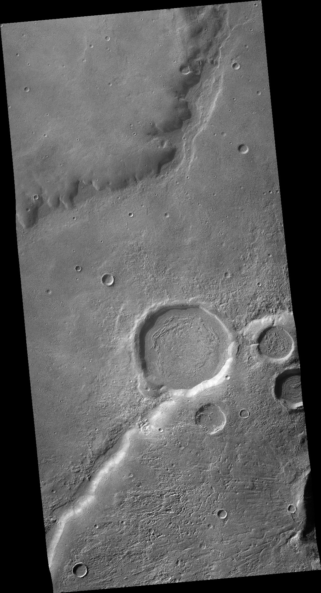
Cool image time! The photo to the right, rotated, cropped, and reduced to post here, was taken on September 30, 2020 by the high resolution camera on Mars Reconnaissance Orbiter (MRO).
It shows one half of what scientists have dubbed a pollywog crater, in which there is a single breach in the crater wall, aligned with the low point in the crater’s floor. Such craters suggest that they were once water- or ice-filled, and that they drained out through the breach either quickly in a single event or slowly over multiple events.
The second image below was taken by the wide angle context camera on MRO, and not only shows this entire crater, but several other adjacent craters, all of which show evidence of glacial fill in their interiors. The latitude here is 34 degrees south, placing these craters within the mid-latitude bands where such glacial features have been found by scientists in great numbers.
Click for full image.
The crater in the first image above is in the center right.
To get a deeper understanding of what we see here, I contacted Edwin Kite of the University of Chicago, who requested this specific image. He provided me a copy of a paper just published in the journal Earth and Planetary Science Letters that tried to model the drainage events that formed these craters and their exit breaches.
The paper’s model predicted that drainage through the breach would have occurred in a single event for at least 2 of 21 studied Martian pollywog craters. Actual observations of those craters on Mars however does not match this model, and instead suggests the drainage occurred over a longer time span across multiple smaller events for all the observed pollywogs.
These results suggest that the craters were once ice-filled, ice brought there during the periods when the planet’s rotational tilt, or obliquity, was high, as high as 60 degrees. At that time, the mid-latitudes were colder than the poles, so that water would sublimate away from the poles and fall as snow in the mid-latitudes.
In the case of this crater the exit breach was formed when that ice began to sublimate away as the obliquity began to lower to the present tilt of 25 degrees. That sublimation took place across many small seasonal and cyclical events, both by sublimation and short flows through the breach. While the sublimation would not have caused the erosion that formed the breach, the small flows would have. To quote their conclusions:
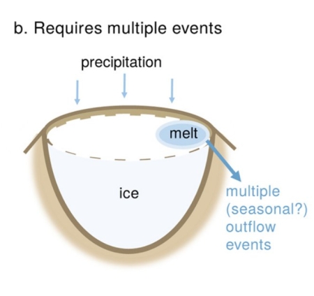
Pollywog craters were predominantly filled with ice that underwent a small amount of melting many times (e.g. seasonally). This formed small melt ponds that drained over the crater rim, contributing a small amount of valley floor erosion each time the climate enabled meltwater to form.
The cartoon to the right, taken from figure 2 of the paper, illustrates the process.
Since all the craters in the context image appear to have glacial features in their interior, this conclusion appears sensible. And since three of four of the large craters appear to have one or more exit breaches, this conclusion also suggests that this process was not necessarily unusual when Mars’ mid-latitude glaciers had just passed their peak and were beginning the process of disappearing.

On Christmas Eve 1968 three Americans became the first humans to visit another world. What they did to celebrate was unexpected and profound, and will be remembered throughout all human history. Genesis: the Story of Apollo 8, Robert Zimmerman's classic history of humanity's first journey to another world, tells that story, and it is now available as both an ebook and an audiobook, both with a foreword by Valerie Anders and a new introduction by Robert Zimmerman.
The print edition can be purchased at Amazon or from any other book seller. If you want an autographed copy the price is $60 for the hardback and $45 for the paperback, plus $8 shipping for each. Go here for purchasing details. The ebook is available everywhere for $5.99 (before discount) at amazon, or direct from my ebook publisher, ebookit. If you buy it from ebookit you don't support the big tech companies and the author gets a bigger cut much sooner.
The audiobook is also available at all these vendors, and is also free with a 30-day trial membership to Audible.
"Not simply about one mission, [Genesis] is also the history of America's quest for the moon... Zimmerman has done a masterful job of tying disparate events together into a solid account of one of America's greatest human triumphs."--San Antonio Express-News
Unrelated to the topic, but I enjoy that the lighting in this pic means the entirety of the crater walls are visible. Those are no gentle slopes, but some almost vertical cliffs… It would be something to see to stand at the bottom and look up! And scary as hell to look over and down!
What it looks like, is some sort of hibernating Thing from an H. P. Lovecraft story.
Just an amateur’s observation, the overview larger picture tells a more complete story.
The northern/top part of the strip shows a massive mountain flow of material, (lava?) probably immense in size. Below it appears to be the remains of a river channel where melting material squeezed out of the surface, flowed away between the craters eventually breaching and filling. The Sandy river/crusty material is more reflective giving a white reflective appearance.
As the material built up, the flow that went around the craters began flowing through them filling them up as evidence by the swirl pattern, like a vortex, in the large crater that received the blunt of the flow. Then exited on the right side lowest section. The tad pole crater next to it did not receive the full flow but has the markings of the crater wall collapsing creating the appearance of a bowl of cereal. Apparently the crater wall is not as dense as the flowing material that filled the crater.
Just below it there’s another crater that had a wall collapse (south side) and it drifted across the crater and is still visible. Not as much liquid sediment material breached into the crater by evidence of the higher walls.
Below that, just outside of the picture is a large violent impact crater that has ejector markings radiating lines from the right side of the picture to the left which looks beautiful and fascinating.
On the original extreme close-up tadpole picture, there are numerous circle shadows in the landscape at top (with drainage channels flowing out of them) and mostly bottom of the picture. Are these windows? Some of them are just shadows by evidence of the brightness on one side but the others look like caves. If water evaporate from beneath the surface, old ice fields like this could be very dangerous to cross having voids beneath them.
Max: That massive flow could be lava but I think it is almost certainly glacial, and likely ice buried under a several feet thick layer of debris to protect it. Remember, this is at 34 degrees south latitude, where such glacial features appear quite common.
Make sure you look at the context image on the main image page for this cool image. Make sure also that you both zoom in and out to get a sense of the entire surrounding terrain. This location is not only at the right latitude, it is also at a relatively high elevation for the cratered highlands, increasing the likelihood that the glacial ice here is still present.