
A really really big landslide on Mars

Click for original image.
Sometimes the cool geological features I find in the Mars Reconnaissance Orbiter (MRO) image archive are so large they are difficult to present on this webpage. Today is an example. The picture to the right, cropped, reduced, and sharpened to post here, was taken on March 13, 2024 by the high resolution camera on MRO. It shows the distinct run-out of debris from a landslide that flowed downhill to the north as a single unit of material. Along the way it carved its track in the ground, almost like a ramp.
The full picture however suggested something much more spectacular. In that full image this landslide is merely a small side avalanche to a landslide many times larger. And that high resolution picture only shows what appears to be a small section of that giant slide. Obviously, this required a look at the global mosaic produced by MRO’s context camera to find out how far that avalanche actually extended.
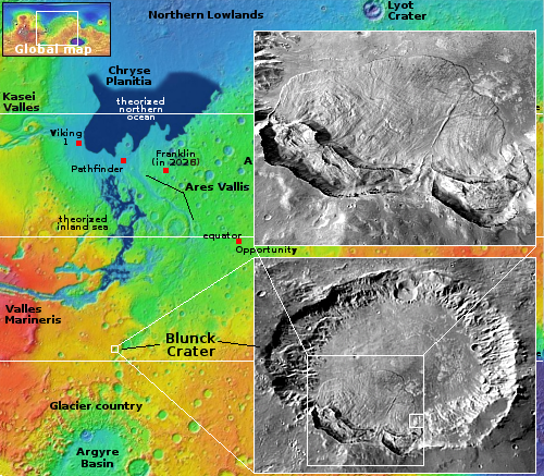
On the overview map to the right the small white box south of Valles Marineris marks the location, inside forty-mile-wide Blunck Crater. On the bottom inset the small white rectangle indicates the area covered by the picture above. The the larger rectangle outlines the full avalanche, caused by the collapse of almost half of the crater’s entire south rim. The upper inset zooms in on that entire slide, which is at least fifteen miles wide. When it came down the material flowed fast in Mars’ one-third gravity and ran out into the crater floor ten to thirteen miles.
Scientists have used this landslide to study what happens when material on Mars collapses in this manner. For example, in this paper [pdf] they attempt to figure out why the landslide material shows many parallel ridges and narrow hollows, all aligned in the direction of the flow.
The location is at 27.5 degrees south latitude, putting it just inside Mars’ dry tropics but close enough to the glacial mid-latitudes that there might be some ice embedded in the ground but not right at the surface. If present, that ice might help explain the nature of this avalanche, which seems very mudlike.
All a guess however. Not enough data is yet available to come to any firm conclusions.

On Christmas Eve 1968 three Americans became the first humans to visit another world. What they did to celebrate was unexpected and profound, and will be remembered throughout all human history. Genesis: the Story of Apollo 8, Robert Zimmerman's classic history of humanity's first journey to another world, tells that story, and it is now available as both an ebook and an audiobook, both with a foreword by Valerie Anders and a new introduction by Robert Zimmerman.
The print edition can be purchased at Amazon or from any other book seller. If you want an autographed copy the price is $60 for the hardback and $45 for the paperback, plus $8 shipping for each. Go here for purchasing details. The ebook is available everywhere for $5.99 (before discount) at amazon, or direct from my ebook publisher, ebookit. If you buy it from ebookit you don't support the big tech companies and the author gets a bigger cut much sooner.
The audiobook is also available at all these vendors, and is also free with a 30-day trial membership to Audible.
"Not simply about one mission, [Genesis] is also the history of America's quest for the moon... Zimmerman has done a masterful job of tying disparate events together into a solid account of one of America's greatest human triumphs."--San Antonio Express-News
Those kind of long-fall-out landslides (or sturzstroms) are pretty amazing, not to speak of disconcerting; I remember a vivid and memorable recounting of such an event in Kim Stanley Robinson’s Red Mars (if I recall correctly which of his trilogy it’s in)—but they also occur on earth (+ other planets, the moon, moons, and even apparently on tiny Phobos).
Here on earth, there’s supposed to be a relatively recent such occurrence, which can be visited (though I never have), near Mount Lassen (in its National Park) in Northern California. But closer to (my) home (Siskiyou County in far-northern California), Mount Shasta—at 14,179 ft. (4,322 meters), tallest and bulkiest “stratovolcano” in the volcanic Cascade Range (stretching from [that same Mount Lassen in] Northern California into British Columbia, Canada)—provides a near-at-hand, eye-opening exemplar, though not so dramatically recent and well-preserved.
As it happened, Mount Shasta’s previous incarnation as a mountain—rather than blowing itself sky-high, as did (e.g.) Mount Mazama (at what’s now known as “Crater Lake”), Oregon—instead, some 150,000 years back (i.e., within the lifespan of our own species, though there were no humans in North America at the time), the precursor-Mt. Shasta stratovolcano simply collapsed, producing the kind of long-fall-out landslide that we’ve been talking about.
As it happens, some 30 miles northwest of Mt. Shasta lies the county seat of Yreka (pronounced “Why-Ree’-ka”: i.e., the Shasta Indians’ name for what we call Mount Shasta). The precursor-Mt. Shasta’s collapsing landslide didn’t quite reach to Yreka’s present location—the slide diverted north before it got there—but in all it traveled some 40 miles [64 km], nearly reaching (California’s 3rd largest river) the Klamath. As a result, all along the Shasta Valley north and west of the modern Mt. Shasta (traversed by Interstate-5) one finds odd-looking, so-called “hummocky terrain” resulting from the great slide 150 millennia ago. (Almost the entire modern Mt. Shasta mountain has rebuilt itself since.)
Beyond that, from near Yreka, or to the north closer to the Klamath, (the present) Mt. Shasta doesn’t loom overhead or protrude far above the horizon; rather, while still wholly dramatic as a mountain, it’s definitely over there next to the horizon, compared with nearby mountains. It’s incredible to me that one could stand near those locations, watching the mountain collapse in the distance (seemingly safe where you are), but actually—unless one takes prompt action to get to higher or protected ground—the landslide would thereupon reach all the way up to and sweep over one, perhaps half an hour later. (Sturzstroms are kind of like tsunamis in that regard.)