A “What the heck?” glacier image on Mars
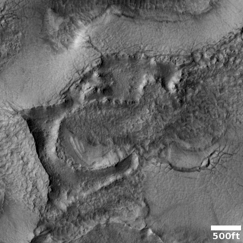
Sometimes a cool image goes from bafflement to obvious as you zoom into it. The cool image to the right, cropped to post here, does the opposite. It was taken on October 11, 2022 by the high resolution camera on Mars Reconnaissance Orbiter (MRO). I have purposely cropped it at full resolution, so that its eroded glacier nature is most obvious.
The cracks and hollows are likely caused by the sublimation of the near surface underground ice, breaking upward so that the protective surface layer of debris and dust collapses at some points, and cracks at others.
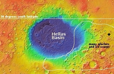
The overview map below further confirms the likelihood that we are looking at glacial features, but when we also zoom out from this close-up we discover things are not so easily explained.

The black cross about 2,000 miles east of Hellas Basin marks the location of the image above. As you can see, it is inside a region where planetary scientists have identified many ice features, from ice scarps to a near-surface ice table to glacial features. If you look in the northwest part of the white outlined area, you can faintly see the meandering Dao, Harmakhis, and Reull valleys, each filled with many-miles-long glaciers.
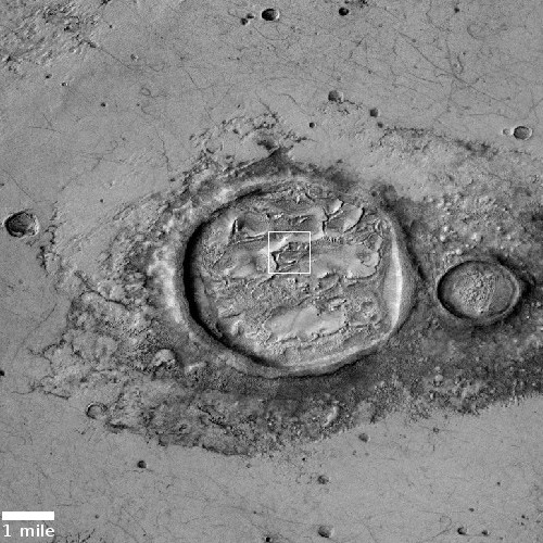
The second image to the right, cropped to post here, was taken on December 14, 2020 by MRO’s context camera, and thus shows us a wider area. The white rectangle indicates the area covered by the high resolution image above.
This wide image makes things very unclear, and in fact to my eye is another one of my Martian “What the heck?” pictures. Though this glacial material appears to fill the crater, that crater also appears to be upraised compared to the surrounding terrain. Moreover, the surrounding terrain looks like dry bedrock, not ground infused with ice. Its smoothness actually argues against ice, since exposed ice would sublimate in the Martian climate, and become eroded and uneven.
And if it is ice, protected by a thin mantle of dust and debris, why has it remained so undisturbed? Similar ice sheets in the northern lowland plains are never this smooth, even if well protected. (See for example here and here.)
Other questions: Why is the crater the only place where glacial features appear obvious, and disturbed? Why is the crater upraised? Did the impact disturb ice-infused ground, or did the ice come later, and then partly sublimate away?
I don’t pretend I can make sense of this. Any geologists out there are welcome to suggest their own theories.
On Christmas Eve 1968 three Americans became the first humans to visit another world. What they did to celebrate was unexpected and profound, and will be remembered throughout all human history. Genesis: the Story of Apollo 8, Robert Zimmerman's classic history of humanity's first journey to another world, tells that story, and it is now available as both an ebook and an audiobook, both with a foreword by Valerie Anders and a new introduction by Robert Zimmerman.
The print edition can be purchased at Amazon or from any other book seller. If you want an autographed copy the price is $60 for the hardback and $45 for the paperback, plus $8 shipping for each. Go here for purchasing details. The ebook is available everywhere for $5.99 (before discount) at amazon, or direct from my ebook publisher, ebookit. If you buy it from ebookit you don't support the big tech companies and the author gets a bigger cut much sooner.
The audiobook is also available at all these vendors, and is also free with a 30-day trial membership to Audible.
"Not simply about one mission, [Genesis] is also the history of America's quest for the moon... Zimmerman has done a masterful job of tying disparate events together into a solid account of one of America's greatest human triumphs."--San Antonio Express-News
Sometimes a cool image goes from bafflement to obvious as you zoom into it. The cool image to the right, cropped to post here, does the opposite. It was taken on October 11, 2022 by the high resolution camera on Mars Reconnaissance Orbiter (MRO). I have purposely cropped it at full resolution, so that its eroded glacier nature is most obvious.
The cracks and hollows are likely caused by the sublimation of the near surface underground ice, breaking upward so that the protective surface layer of debris and dust collapses at some points, and cracks at others.
The overview map below further confirms the likelihood that we are looking at glacial features, but when we also zoom out from this close-up we discover things are not so easily explained.

The black cross about 2,000 miles east of Hellas Basin marks the location of the image above. As you can see, it is inside a region where planetary scientists have identified many ice features, from ice scarps to a near-surface ice table to glacial features. If you look in the northwest part of the white outlined area, you can faintly see the meandering Dao, Harmakhis, and Reull valleys, each filled with many-miles-long glaciers.
The second image to the right, cropped to post here, was taken on December 14, 2020 by MRO’s context camera, and thus shows us a wider area. The white rectangle indicates the area covered by the high resolution image above.
This wide image makes things very unclear, and in fact to my eye is another one of my Martian “What the heck?” pictures. Though this glacial material appears to fill the crater, that crater also appears to be upraised compared to the surrounding terrain. Moreover, the surrounding terrain looks like dry bedrock, not ground infused with ice. Its smoothness actually argues against ice, since exposed ice would sublimate in the Martian climate, and become eroded and uneven.
And if it is ice, protected by a thin mantle of dust and debris, why has it remained so undisturbed? Similar ice sheets in the northern lowland plains are never this smooth, even if well protected. (See for example here and here.)
Other questions: Why is the crater the only place where glacial features appear obvious, and disturbed? Why is the crater upraised? Did the impact disturb ice-infused ground, or did the ice come later, and then partly sublimate away?
I don’t pretend I can make sense of this. Any geologists out there are welcome to suggest their own theories.
On Christmas Eve 1968 three Americans became the first humans to visit another world. What they did to celebrate was unexpected and profound, and will be remembered throughout all human history. Genesis: the Story of Apollo 8, Robert Zimmerman's classic history of humanity's first journey to another world, tells that story, and it is now available as both an ebook and an audiobook, both with a foreword by Valerie Anders and a new introduction by Robert Zimmerman.
The print edition can be purchased at Amazon or from any other book seller. If you want an autographed copy the price is $60 for the hardback and $45 for the paperback, plus $8 shipping for each. Go here for purchasing details. The ebook is available everywhere for $5.99 (before discount) at amazon, or direct from my ebook publisher, ebookit. If you buy it from ebookit you don't support the big tech companies and the author gets a bigger cut much sooner.
The audiobook is also available at all these vendors, and is also free with a 30-day trial membership to Audible.
"Not simply about one mission, [Genesis] is also the history of America's quest for the moon... Zimmerman has done a masterful job of tying disparate events together into a solid account of one of America's greatest human triumphs."--San Antonio Express-News


That’s where I went muddin’
– Billy Carter of Mars
I am a geologist and my initial guess is that the water/ice came from the meteor.
“Why is the crater upraised” I’m surprised that this one threw you, but I saw it the same way as you at first glance – as B&W photos of craters and other land features often do if it isn’t obvious which direction the light is coming from. Light is coming from the left side of the images, not the upper right. So the dark semicircle to the lower left of the crater is the shadow of the crater’s ring wall. Similarly, you see shadows on the upper right outside the ring wall.
Once your brain reverses the direction of light and subsequently your perceived elevations, instead of raised mounds of dust covered ice in the center of the crater, you have ridges with cracks along their tops, and depressed regions between them.
Now not having been there when the crater and the subsequent geomorphology (areo-morphology?) formed (in spite of being very old), and not having had my boots on the ground there (in spite of being moderately well-traveled), I hesitate to speculate on what is filling the crater. So let me tell a story (aka a probably bad hypothesis) that might or might not make sense.
Post the impact (which left about a 5 mile wide crater), water in the surrounding sediments melted and was eventually able to flow across the crater, probably as a mud flow. The lower layers of this should/might be on the edge of boiling/boiling (at a quite low temperature, given Mars’s low atmospheric pressure) and residual heat and gasses from the impact would be emerging from cracks in the young rock surface inside the crater. The upper surface of this mudflow would likely freeze as it tried to sublimate, but the residual heat and outgassing from the crater should cause the water in the mud to escape via the vents which became the ridges we see, while the regions between the ridges subsided as their base layers were depleted of water as it vaporized and outgassed.
Note, I could tell a very similar story using molten rock resultant from an impact. It is very hard to speculate about images from another place where you have never been, even if you’ve looked at a lot of these pictures and been to the places they depicted. :)
Also although I claim to be a geochemist (I could actually be a stray cat with good keyboard skills.) I don’t do this kind of analysis, thus my many disclaimers. I’ve had fairly good luck asking folks at the various Mars projects and at NASA about features I see though when I have questions. For me the big one here is “Is that frozen mud, ice with a dirt coating (I think less likely) or solidified lava?” Maybe there was lava and its areo-morphology and features, and then when the crater cooled enough, ice/mud and its outgassing and features….
With all that said:
Best to all in the New Year, and many happy morphological speculations !
Jeff Wright
December 29, 2022 at 12:45 am
That’s where I went muddin’
– Billy Carter of Mars
LOL – threadwinner with the first comment. :)
As a fluid dynamics guy, I wouldn’t think that if the meteor was water, it would have been blown back as ejecta during the impact. This looks like the impact has done what other major major impacts on earth has done – crack a rock subsurface and (here) allow water to come forth when things were still hot.
On earth, large impacts like this result in leakage of the large amounts of abiotic oil from the mantle, upwards (such as in the Gulf of Mexico).
On a serious note- the original “Three Minutes ’til Impact” talked about horizontal scars thought to result from uber shallow angle skips. Could some seamounts be nickel-iron slugs instead of guyots?