Ascraeus Mons, Mars’ second highest mountain

Today’s cool Mars’ image started out when I came across an interesting image of a depression on the northern flank of the giant Martian volcano Ascraeus Mons, the northernmost of the line of three giant volcanoes just to the east of the biggest of all, Olympus Mons.
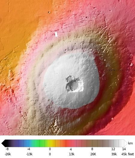
To provide context I created an overview showing the entire volcano (with the white rectangle showing the location of the depression image), and suddenly realized that this overview might actually be more interesting to my readers. To the right is that overview of Ascreaus, with a scale across the bottom to indicate the elevation of the mountain above what scientists have determined to be Mars’ pseudo sea level.
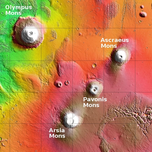
Notice that this volcano, the second highest on Mars, rises more than 43,000 feet above the surrounding plains. Its peak is estimated to be about 59,000 feet high, making it taller than Mt. Everest by about 30,000 feet (more than twice its height). Its diameter is approximately 300 miles across, giving it a much steeper profile than the higher but more spread out Olympus Mons. The map below shows this mountain in relation to Olympus as well as its nearby partner volcanoes.

Olympus Mons’ peak is at about 70,000 feet, making it another 11,000 feet higher, but since its diameter is about twice as wide the general slope of its flanks is less than Ascraeus. Arsia Mons, Mars’ third highest mountain, is 58,000 feet high, while Pavonis Mons, the fourth, is about 47,000 feet.
These four volcanoes sit on what scientists dub the Tharsis Bulge, a place on Mars where the general altitude of the surface rises above the rest of the planet by 4,000 to 10,000 feet.
These mountains are big, so big in fact that if you were walking on the plains between them you really could not see them. Their profiles are just not that pronounced against the general curve of the globe, and their peaks would not be visible against the horizon.
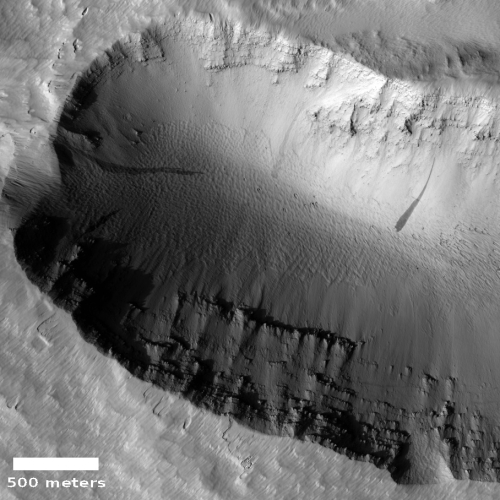
Returning to the original image on Ascraeus’ northern slopes, note the east-west cracks on that flank. It appears that there has been some slow sagging of that flank downward to the north, causing cracks to form. The subject image to the right, cropped and reduced to post here, was taken on April 28, 2020 by the high resolution camera on Mars Reconnaissance Orbiter (MRO), and focuses on several of those depressions.
In this one image we can see much of Mars’ mysterious geology. Near the top of this depression’s cliffs can be seen many layers, each indicating a past volcanic event that laid another sheet of lava across the flank of this volcano. The time involved and complex history that made these many layers staggers the mind, if you think about it for a bit.
Also on the depression’s slope can be several slope streaks, a geological feature unique to Mars that is not yet understood. These are not avalanches, as the topology remains unchanged. Instead, they appear to be some sort of staining process on the surface that is triggered by a rockfall at the top that then propagates downward.
In the depression’s floor appear to be dunes, laid out in a ripple pattern that resembles the wake seen behind a boat. The process that allowed winds to cause this pattern, however, here in a protected hole, leaves me baffled.
On Christmas Eve 1968 three Americans became the first humans to visit another world. What they did to celebrate was unexpected and profound, and will be remembered throughout all human history. Genesis: the Story of Apollo 8, Robert Zimmerman's classic history of humanity's first journey to another world, tells that story, and it is now available as both an ebook and an audiobook, both with a foreword by Valerie Anders and a new introduction by Robert Zimmerman.
The print edition can be purchased at Amazon or from any other book seller. If you want an autographed copy the price is $60 for the hardback and $45 for the paperback, plus $8 shipping for each. Go here for purchasing details. The ebook is available everywhere for $5.99 (before discount) at amazon, or direct from my ebook publisher, ebookit. If you buy it from ebookit you don't support the big tech companies and the author gets a bigger cut much sooner.
The audiobook is also available at all these vendors, and is also free with a 30-day trial membership to Audible.
"Not simply about one mission, [Genesis] is also the history of America's quest for the moon... Zimmerman has done a masterful job of tying disparate events together into a solid account of one of America's greatest human triumphs."--San Antonio Express-News

Today’s cool Mars’ image started out when I came across an interesting image of a depression on the northern flank of the giant Martian volcano Ascraeus Mons, the northernmost of the line of three giant volcanoes just to the east of the biggest of all, Olympus Mons.
To provide context I created an overview showing the entire volcano (with the white rectangle showing the location of the depression image), and suddenly realized that this overview might actually be more interesting to my readers. To the right is that overview of Ascreaus, with a scale across the bottom to indicate the elevation of the mountain above what scientists have determined to be Mars’ pseudo sea level.
Notice that this volcano, the second highest on Mars, rises more than 43,000 feet above the surrounding plains. Its peak is estimated to be about 59,000 feet high, making it taller than Mt. Everest by about 30,000 feet (more than twice its height). Its diameter is approximately 300 miles across, giving it a much steeper profile than the higher but more spread out Olympus Mons. The map below shows this mountain in relation to Olympus as well as its nearby partner volcanoes.

Olympus Mons’ peak is at about 70,000 feet, making it another 11,000 feet higher, but since its diameter is about twice as wide the general slope of its flanks is less than Ascraeus. Arsia Mons, Mars’ third highest mountain, is 58,000 feet high, while Pavonis Mons, the fourth, is about 47,000 feet.
These four volcanoes sit on what scientists dub the Tharsis Bulge, a place on Mars where the general altitude of the surface rises above the rest of the planet by 4,000 to 10,000 feet.
These mountains are big, so big in fact that if you were walking on the plains between them you really could not see them. Their profiles are just not that pronounced against the general curve of the globe, and their peaks would not be visible against the horizon.
Returning to the original image on Ascraeus’ northern slopes, note the east-west cracks on that flank. It appears that there has been some slow sagging of that flank downward to the north, causing cracks to form. The subject image to the right, cropped and reduced to post here, was taken on April 28, 2020 by the high resolution camera on Mars Reconnaissance Orbiter (MRO), and focuses on several of those depressions.
In this one image we can see much of Mars’ mysterious geology. Near the top of this depression’s cliffs can be seen many layers, each indicating a past volcanic event that laid another sheet of lava across the flank of this volcano. The time involved and complex history that made these many layers staggers the mind, if you think about it for a bit.
Also on the depression’s slope can be several slope streaks, a geological feature unique to Mars that is not yet understood. These are not avalanches, as the topology remains unchanged. Instead, they appear to be some sort of staining process on the surface that is triggered by a rockfall at the top that then propagates downward.
In the depression’s floor appear to be dunes, laid out in a ripple pattern that resembles the wake seen behind a boat. The process that allowed winds to cause this pattern, however, here in a protected hole, leaves me baffled.
On Christmas Eve 1968 three Americans became the first humans to visit another world. What they did to celebrate was unexpected and profound, and will be remembered throughout all human history. Genesis: the Story of Apollo 8, Robert Zimmerman's classic history of humanity's first journey to another world, tells that story, and it is now available as both an ebook and an audiobook, both with a foreword by Valerie Anders and a new introduction by Robert Zimmerman.
The print edition can be purchased at Amazon or from any other book seller. If you want an autographed copy the price is $60 for the hardback and $45 for the paperback, plus $8 shipping for each. Go here for purchasing details. The ebook is available everywhere for $5.99 (before discount) at amazon, or direct from my ebook publisher, ebookit. If you buy it from ebookit you don't support the big tech companies and the author gets a bigger cut much sooner.
The audiobook is also available at all these vendors, and is also free with a 30-day trial membership to Audible.
"Not simply about one mission, [Genesis] is also the history of America's quest for the moon... Zimmerman has done a masterful job of tying disparate events together into a solid account of one of America's greatest human triumphs."--San Antonio Express-News


Given enough time, I expect dunes to be any where you look.
That track on the right hand of the last image is very interesting since it cuts thru the dunes. I can see a rock breaking away and gathering buddies down the slope.
Btw….. Thank you for all of the interesting things you bring out!
MarcusZ1967: If by the “track on the right hand” you are referring to the dark streak down the slope, that is not an avalanche of rocks, that is a slope streak. Click on the link under those words in the post. A lot of research has been done on these streaks, and they are definitely not what the appear at first glance.
If there is another track cutting across the dunes in the depression’s floor, I don’t see it. Can you provide a better description about where it is?