
Freaky badlands on Mars
Click for full image.
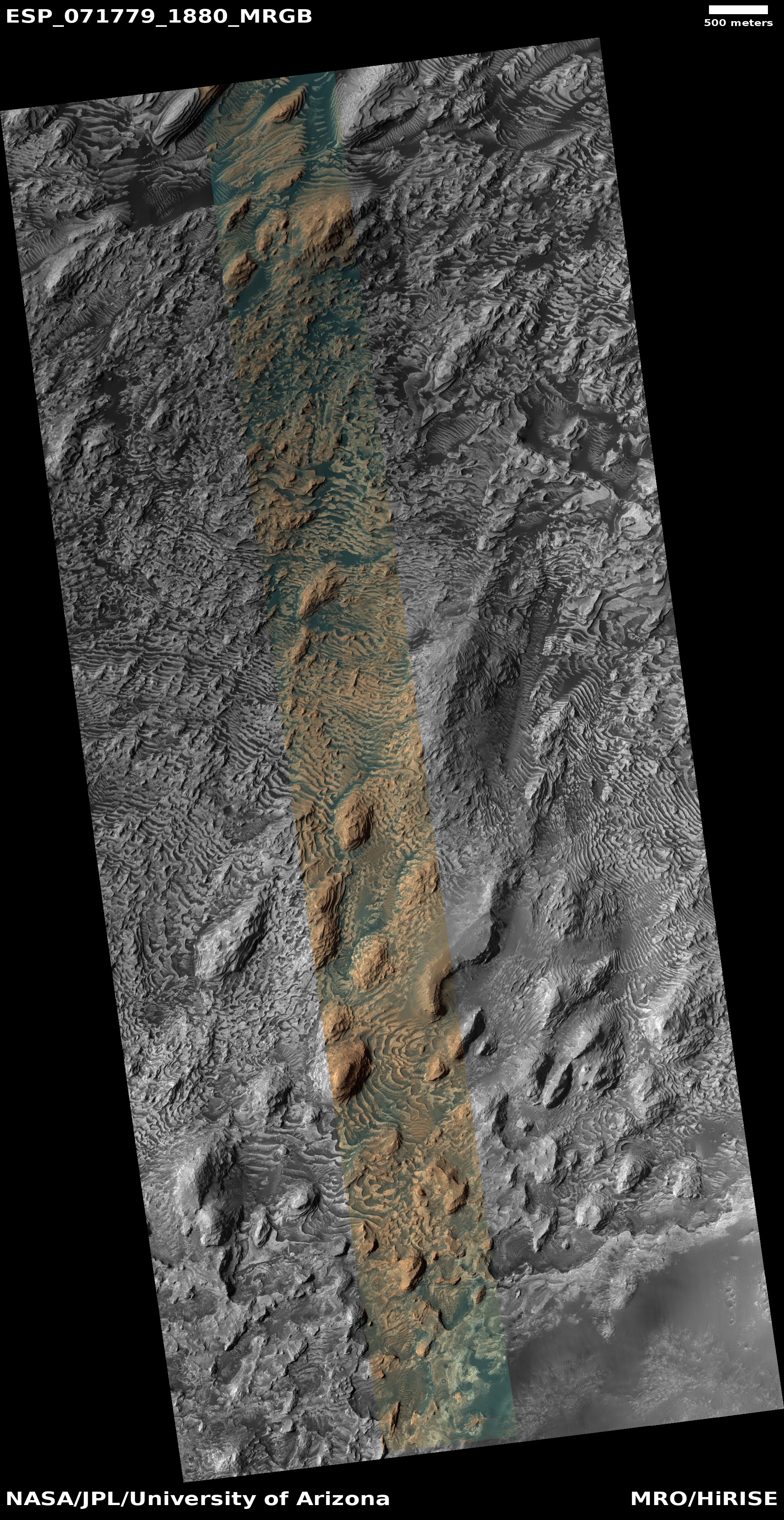
Cool image time! The photo to the right, rotated and cropped to post here, was taken on November 18, 2021 by the high resolution camera on Mars Reconnaissance Orbiter (MRO). Labeled merely as “Danielson Crater Outcrops,” it shows us a perfect example of the strangeness and sometimes very forbidding terrain of Mars.
We are looking at the outcrop tops of many tilted layers, worn into curves semicircles with the convex side all pointing to the southwest. In the hollowed concave-side, dust and sand have accumulated and been trapped, sometimes forming small ripple dunes when there is enough space for the wind to get inside, as seen in the picture’s lower right.
Danielson Crater is 41 miles in diameter. The overview map below provides the context.
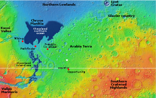
The white dot marks this photo’s location, in the southeast quadrant of the crater floor. Scientists have used MRO to take many high resolution images of this crater interior because the pictures reveal many such tilted layers.
At present scientists have no real understanding of what caused these layers. They could have been put down either by the Martian atmospheric climate cycles, where the widely changing tilt of the planet caused many swings over many eons. Or this crater floor might have once been under water, either filled like a lake or at the bottom of a larger sea. No one knows, though scientists have found evidence suggesting an inland sea might have once existed to the west in the outlet from Valles Marineris.
What we likely do know is that the impact that created the crater occurred after the layers were created, meaning that they are very old. We also can see that travel in these badlands is likely to be very difficult for any ground-based vehicle. Exploration will likely only be practical with some form of helicopter.
Below is a beautiful 3d fly-over animation using MRO photos. It makes it very easy to see the layers and their tilted nature.

On Christmas Eve 1968 three Americans became the first humans to visit another world. What they did to celebrate was unexpected and profound, and will be remembered throughout all human history. Genesis: the Story of Apollo 8, Robert Zimmerman's classic history of humanity's first journey to another world, tells that story, and it is now available as both an ebook and an audiobook, both with a foreword by Valerie Anders and a new introduction by Robert Zimmerman.
The print edition can be purchased at Amazon or from any other book seller. If you want an autographed copy the price is $60 for the hardback and $45 for the paperback, plus $8 shipping for each. Go here for purchasing details. The ebook is available everywhere for $5.99 (before discount) at amazon, or direct from my ebook publisher, ebookit. If you buy it from ebookit you don't support the big tech companies and the author gets a bigger cut much sooner.
The audiobook is also available at all these vendors, and is also free with a 30-day trial membership to Audible.
"Not simply about one mission, [Genesis] is also the history of America's quest for the moon... Zimmerman has done a masterful job of tying disparate events together into a solid account of one of America's greatest human triumphs."--San Antonio Express-News
Remarkable animation. Thanks for the virtual fly-over.
Speaking of layers, Curiosity’s recent photo examination of the rock formation “Prow” had me just as amazed.
http://www.unmannedspaceflight.com/index.php?showtopic=8644&view=findpost&p=255907
Click on photo for full resolution version. Photo credit to user PaulH51.
Mr. Zimmerman:
Thank you for posting the incredible picture and video; I would not have found them on my own.
I live in northwestern Wyoming where we get occasional heavy snow during cold nights, but always have very high winds. In fact. my small town is renowned for having some of the windiest areas in the lower 48, particularly right where I live. The only problem is that the snow almost never lasts long enough to melt into the ground before it is blown away. The joke here is, “Snow never melts in Wyoming, it just blows around until it wears out.”
The shapes of the “waves” very closely resemble what’s left on the ground here just before the snow is scoured to the bare grass. At low temperatures (below -20°F) snow is extremely abrasive, probably much like the Martian dust, and so the wind and snow leave patterns that are very similar to these images.
Blackwing 1: If this is your first visit here, you can have some fun looking at a lot of cool images by simply searching the website for “cool image.”
Mr. Zimmerman:
Thanks for the courtesy of the reply. Naw, I’ve been surfing your site for a while (years?) and have even commented previously.
I just really liked those particular pictures of the Martian surface since they looked so familiar.
In any case, I greatly appreciate your “blacklisted” posts as well as the imagery and space commercialization information.
Blackwing1