
Why a big Earth mountain would hardly be noticed on Mars
Click for full image.
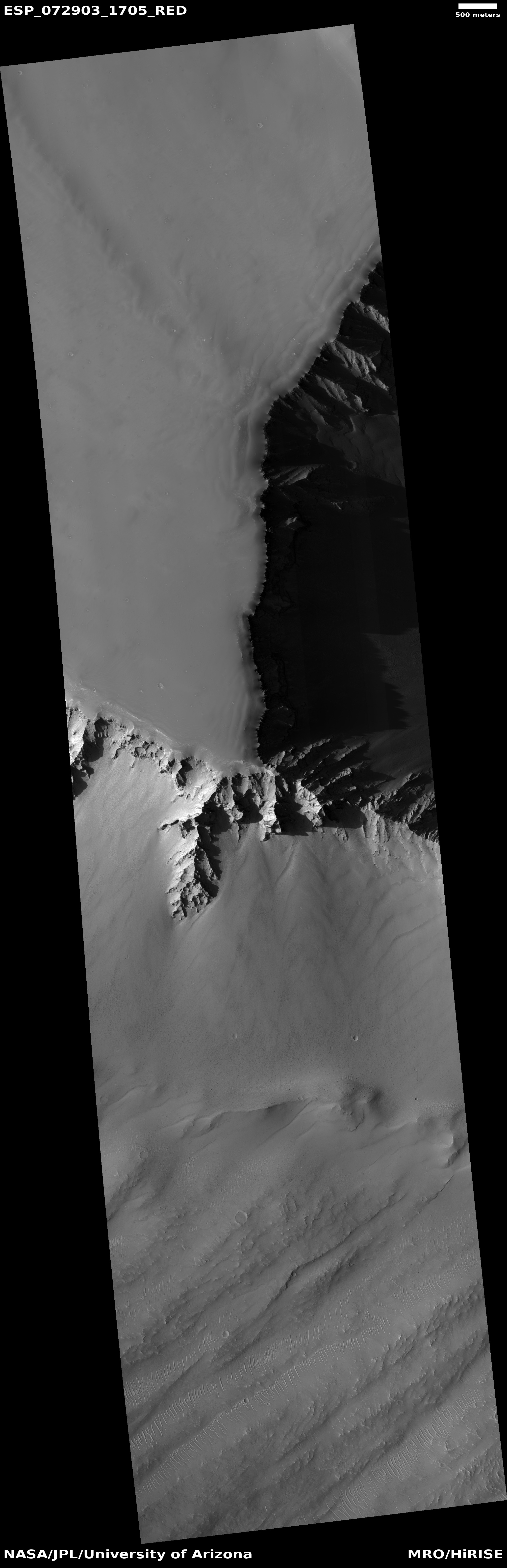
Cool image time! The photo to the right, cropped and reduced to post here, was taken on February 13, 2022 by the high resolution camera on Mars Reconnaissance Orbiter (MRO). It shows a cliff escarpment that, based on a rough estimate of MRO’s elevation data, ranges from 10,000 to 13,000 feet high. Because the sun is only about 32 degrees above the western horizon, the shadows are long and distinct and bring out the features quite dramatically.
On Earth, a mountain 13,000 feet high would generally be named, because there are really not that many of them. If it was a cliff face dropping down into a canyon, which this Martian cliff is, it would be quite unique and probably be one of the most popular tourist spots on the globe. For comparison, the rim of the Grand Canyon in the national park, visited by millions, is only 4,000 to 6000 feet in elevation. This cliff on Mars is more than twice as deep, and yet, it is hardly the most spectacular canyon rim on the red planet.
The overview map below explains this.
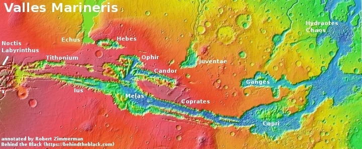
The location of this image is marked by the small white rectangle on the left edge in Noctis Labyrinthus. In fact, this cliff is actually not the outside wall of this canyon, but the flank of an interior mesa.
It is also not very large when compared to the elevation differences found throughout the 2,500-mile-long and 400-mile wide Valles Marineris to the east. Along its length the depth from rim to floor is generally about 25,000 feet, more or less. At that depth, almost all mountains on Earth would fit inside, with only a few topping the rim.

On Christmas Eve 1968 three Americans became the first humans to visit another world. What they did to celebrate was unexpected and profound, and will be remembered throughout all human history. Genesis: the Story of Apollo 8, Robert Zimmerman's classic history of humanity's first journey to another world, tells that story, and it is now available as both an ebook and an audiobook, both with a foreword by Valerie Anders and a new introduction by Robert Zimmerman.
The print edition can be purchased at Amazon or from any other book seller. If you want an autographed copy the price is $60 for the hardback and $45 for the paperback, plus $8 shipping for each. Go here for purchasing details. The ebook is available everywhere for $5.99 (before discount) at amazon, or direct from my ebook publisher, ebookit. If you buy it from ebookit you don't support the big tech companies and the author gets a bigger cut much sooner.
The audiobook is also available at all these vendors, and is also free with a 30-day trial membership to Audible.
"Not simply about one mission, [Genesis] is also the history of America's quest for the moon... Zimmerman has done a masterful job of tying disparate events together into a solid account of one of America's greatest human triumphs."--San Antonio Express-News
Cool image!
Depends on where you measure on Earth. Mt. Lamlam, the tallest peak on Guam, is 1,332 feet above sea level, but it rises above the Marianas Trench, known to be at least 36,000 feet deep. That compares well with Mars!