Wormlike glacier on Mars
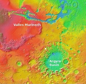
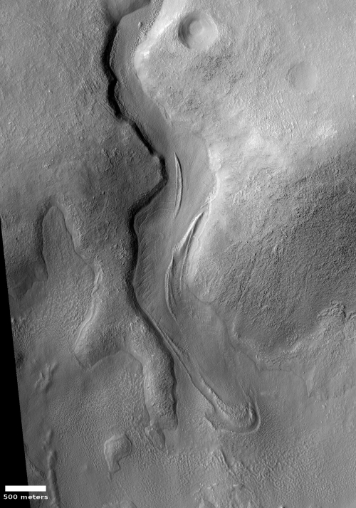
Cool image time! The image to the right, cropped and reduced to post here, shows a very typical glacial-type feature found frequently in the mid-latitudes of Mars. Taken on May 23, 2020 by the high resolution camera on Mars Reconnaissance Orbiter (MRO), it is labeled a “Lobate Flow Feature within Channel in Nereidum Montes.” Nereidum Montes is a rough mountainous region along the northwestern margin of Argyre Basin, the second largest impact basin on Mars, after Hellas Basin.
Scientists using Europe’s Mars Express orbiter have already found a great deal of glacial evidence in these mountains. I have also posted images of other glacial features on the north edge of Argyre. This image just reinforces that data.
This particular glacier however resembles the kind of glaciers one sees on Earth more than most Martian glaciers. As it meanders down its valley, large cracks form near its edges as friction slows their passage and drags them apart. In fact, the glacier itself might have very well carved the canyon. According to Dan Berman, senior scientist at the Planetary Science Institute in Arizona, who had requested this image,
While I can’t say for sure, the canyon was likely formed by a glacier. Whether or not the ice that remains today is part of that glacier, or one that formed later, is impossible to say.

The overview map to the right gives the larger context, with the white box showing the location of this photo.
At the canyon’s outlet the flow appears to be pushing into a large pond of ice. In fact, it sure looks like there is a lot of ice just below the surface in this lowland, covered by a debris layer to protect it from sublimating away. For example, the hollow to the west of this canyon appears filled with ice material, pushing right up to the cliffs on all sides. According to Berman,
Beyond the glacial lobe to the south, there are textures present that are likely representative of remnant ice. This is likely a deposit commonly referred to as the latitude dependent mantle, a mixture of ice and dust that drapes the mid latitudes. The glacier in the canyon may have formed from the flow of these deposits.
Mars is certainly turning out to be a very icy place, far different than imagined by early scientists and science fiction writers.
On Christmas Eve 1968 three Americans became the first humans to visit another world. What they did to celebrate was unexpected and profound, and will be remembered throughout all human history. Genesis: the Story of Apollo 8, Robert Zimmerman's classic history of humanity's first journey to another world, tells that story, and it is now available as both an ebook and an audiobook, both with a foreword by Valerie Anders and a new introduction by Robert Zimmerman.
The print edition can be purchased at Amazon or from any other book seller. If you want an autographed copy the price is $60 for the hardback and $45 for the paperback, plus $8 shipping for each. Go here for purchasing details. The ebook is available everywhere for $5.99 (before discount) at amazon, or direct from my ebook publisher, ebookit. If you buy it from ebookit you don't support the big tech companies and the author gets a bigger cut much sooner.
The audiobook is also available at all these vendors, and is also free with a 30-day trial membership to Audible.
"Not simply about one mission, [Genesis] is also the history of America's quest for the moon... Zimmerman has done a masterful job of tying disparate events together into a solid account of one of America's greatest human triumphs."--San Antonio Express-News
Cool image time! The image to the right, cropped and reduced to post here, shows a very typical glacial-type feature found frequently in the mid-latitudes of Mars. Taken on May 23, 2020 by the high resolution camera on Mars Reconnaissance Orbiter (MRO), it is labeled a “Lobate Flow Feature within Channel in Nereidum Montes.” Nereidum Montes is a rough mountainous region along the northwestern margin of Argyre Basin, the second largest impact basin on Mars, after Hellas Basin.
Scientists using Europe’s Mars Express orbiter have already found a great deal of glacial evidence in these mountains. I have also posted images of other glacial features on the north edge of Argyre. This image just reinforces that data.
This particular glacier however resembles the kind of glaciers one sees on Earth more than most Martian glaciers. As it meanders down its valley, large cracks form near its edges as friction slows their passage and drags them apart. In fact, the glacier itself might have very well carved the canyon. According to Dan Berman, senior scientist at the Planetary Science Institute in Arizona, who had requested this image,
While I can’t say for sure, the canyon was likely formed by a glacier. Whether or not the ice that remains today is part of that glacier, or one that formed later, is impossible to say.

The overview map to the right gives the larger context, with the white box showing the location of this photo.
At the canyon’s outlet the flow appears to be pushing into a large pond of ice. In fact, it sure looks like there is a lot of ice just below the surface in this lowland, covered by a debris layer to protect it from sublimating away. For example, the hollow to the west of this canyon appears filled with ice material, pushing right up to the cliffs on all sides. According to Berman,
Beyond the glacial lobe to the south, there are textures present that are likely representative of remnant ice. This is likely a deposit commonly referred to as the latitude dependent mantle, a mixture of ice and dust that drapes the mid latitudes. The glacier in the canyon may have formed from the flow of these deposits.
Mars is certainly turning out to be a very icy place, far different than imagined by early scientists and science fiction writers.
On Christmas Eve 1968 three Americans became the first humans to visit another world. What they did to celebrate was unexpected and profound, and will be remembered throughout all human history. Genesis: the Story of Apollo 8, Robert Zimmerman's classic history of humanity's first journey to another world, tells that story, and it is now available as both an ebook and an audiobook, both with a foreword by Valerie Anders and a new introduction by Robert Zimmerman.
The print edition can be purchased at Amazon or from any other book seller. If you want an autographed copy the price is $60 for the hardback and $45 for the paperback, plus $8 shipping for each. Go here for purchasing details. The ebook is available everywhere for $5.99 (before discount) at amazon, or direct from my ebook publisher, ebookit. If you buy it from ebookit you don't support the big tech companies and the author gets a bigger cut much sooner.
The audiobook is also available at all these vendors, and is also free with a 30-day trial membership to Audible.
"Not simply about one mission, [Genesis] is also the history of America's quest for the moon... Zimmerman has done a masterful job of tying disparate events together into a solid account of one of America's greatest human triumphs."--San Antonio Express-News


A SHORELINE!!!
A very distinct line where a “lake” may be, even around islands. This kind of proof has been missing in other photos has just now been revealed here. This is a nice catch.
Geologist are probably sharing these pictures like porn, very exciting.
Upon further examination of the original, other details become clear like the black rocks at the bottom of the flow. Piles of gravel that you would expect with a glacier, and again in one of the deeper channels as well as near the distinct Crater with what appears as a very smooth flat bottom.
The flow is not smooth, reminding me of an early freeze on the Yukon River that was broken up and caused uneven surface and ice dams as it refroze. That made driving to the nearby villages difficult and made the annual snowmobile race interesting.
There is also a dark spot like a skylight on the far right. Zoom in and it appears to be a recent meteor impact leaving ejecta in the form of a tadpole.
The Shai Halud?