
The canyon that Curiosity will eventually climb

Click for full resolution. For original images go here and here.
Click for interactive map.
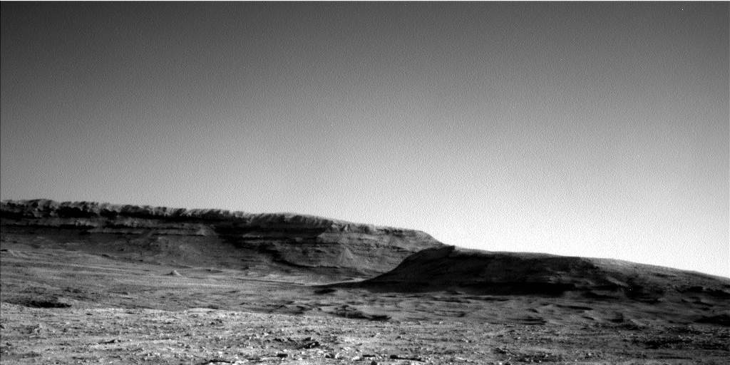
Cool image time! The panorama above, created from two photographs taken on May 23, 2025 by the left navigation camera (here and here) on the Mars rover Curiosity, looks south uphill into the canyon that Curiosity is eventually going to climb.
The overview map to the right provides the context. The blue dot marks Curiosity’s present position, the white dotted line its past travels, the red dotted line its initial planned route, and the green dotted line its future route. The yellow lines indicate the approximate area seen in the panorama above.
If you look on the horizon to the left, you can see very bright terrain higher up the mountain. This is the pure sulfate-bearing unit that is Curiosity’s next major geological goal. It won’t reach that terrain for quite some time however because first the scientists want to spend some time studying the boxwork geology that Curiosity is now approaching. That boxwork suggests two past geological processes, as yet unconfirmed. First it suggests the ground dried like mud, forming a polygon pattern of cracks that then hardened into rock. Second, lava seeped up from below and filled those cracks. The lava, being more resistant to erosion, ended up becoming the boxwork of ridges as the material around eroded away.
This proposed history however is not proven. They hope to find out when Curiosity gets there.
Meanwhile, despite having traveled almost 22 miles, the rover is more than 25 miles from the peak of Mount Sharp, which remains out of sight. That peak is also about 15,000 feet higher.

Click for full resolution. For original images go here and here.

Click for interactive map.
Cool image time! The panorama above, created from two photographs taken on May 23, 2025 by the left navigation camera (here and here) on the Mars rover Curiosity, looks south uphill into the canyon that Curiosity is eventually going to climb.
The overview map to the right provides the context. The blue dot marks Curiosity’s present position, the white dotted line its past travels, the red dotted line its initial planned route, and the green dotted line its future route. The yellow lines indicate the approximate area seen in the panorama above.
If you look on the horizon to the left, you can see very bright terrain higher up the mountain. This is the pure sulfate-bearing unit that is Curiosity’s next major geological goal. It won’t reach that terrain for quite some time however because first the scientists want to spend some time studying the boxwork geology that Curiosity is now approaching. That boxwork suggests two past geological processes, as yet unconfirmed. First it suggests the ground dried like mud, forming a polygon pattern of cracks that then hardened into rock. Second, lava seeped up from below and filled those cracks. The lava, being more resistant to erosion, ended up becoming the boxwork of ridges as the material around eroded away.
This proposed history however is not proven. They hope to find out when Curiosity gets there.
Meanwhile, despite having traveled almost 22 miles, the rover is more than 25 miles from the peak of Mount Sharp, which remains out of sight. That peak is also about 15,000 feet higher.


