
Weird erosion in large Martian craters

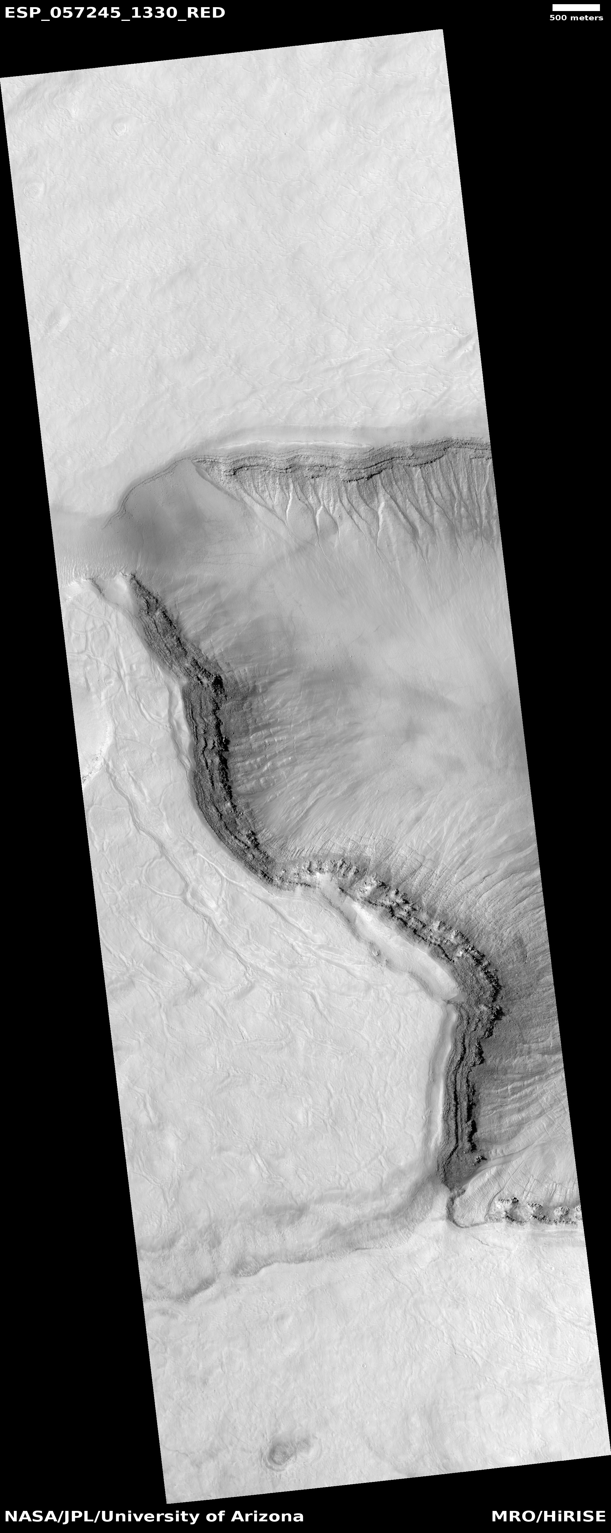
Cool image time! In reviewing the images in the December image release from the high resolution camera on Mars Reconnaissance Orbiter (MRO, I came across the image to the right, cropped, rotated and reduced to post here, showing the western half of the central pit of Asimov Crater. (Click on the link for the entire photograph.) The eastern half can be seen here.
It is unusual to see central pits in craters. One instead expects to see central peaks. The pit itself is intriguing because of its sinkhole appearance. In both the northwest and southwest corners you can clearly see drainages flowing down into the pit, including recent faint darkened streaks indicative of past seep avalanches. The same can been seen for the pit’s eastern half. Along the pit’s western rim are parallel cracks suggesting that the plateau itself is slowly shifting downward into the pit.
Furthermore, the rim cliff has multiple drainage gullies, all beginning just below the initial top layers. The look of those cliffs is very similar to what sees on the walls of the Grand Canyon, where the top of the cliffs show layers with the bottom of the cliffs buried under a slope of alluvial fill, material that has fallen to slowly form those slopes. The drainage gullies however would have come later, and suggest that some form of seepage is coming out of the contact between the layers at the top of the slope.
A look at the context image below and to the right reveals the greater mystery of this crater, as well as nearby Maunder Crater, the subject of a recent captioned image release from Mars Odyssey.
In both cases a circular interior gully separates the crater floor from the crater’s rim. In fact, the crater floor almost appears raised. This is especially striking with Asimov Crater, where the central floor appears like a very flat plateau, except for that central pit and the surrounding gully.
The MRO team has taken a lot of images of the gullies, which you can see if you zoom in to latitude -46.843° longitude 4.831° on the map image at this website. It is clear that they want to know more about the origins of this geology. It suggests water flow, even though these craters are located in the Martian southern highlands, a place that is more reminiscent of the Moon, with many ancient craters and far less evidence of significant change.
What the geology in these two craters suggest is that some erosion process is eating away at the crater floors, beginning at its edges as well where there are voids below that allow the surface to sink. While that erosion is certainly helped by wind, it also implies the presence of underground water, either as ice or liquid, in the past and even possibly today.
Cool image time! In reviewing the images in the December image release from the high resolution camera on Mars Reconnaissance Orbiter (MRO, I came across the image to the right, cropped, rotated and reduced to post here, showing the western half of the central pit of Asimov Crater. (Click on the link for the entire photograph.) The eastern half can be seen here.
It is unusual to see central pits in craters. One instead expects to see central peaks. The pit itself is intriguing because of its sinkhole appearance. In both the northwest and southwest corners you can clearly see drainages flowing down into the pit, including recent faint darkened streaks indicative of past seep avalanches. The same can been seen for the pit’s eastern half. Along the pit’s western rim are parallel cracks suggesting that the plateau itself is slowly shifting downward into the pit.
Furthermore, the rim cliff has multiple drainage gullies, all beginning just below the initial top layers. The look of those cliffs is very similar to what sees on the walls of the Grand Canyon, where the top of the cliffs show layers with the bottom of the cliffs buried under a slope of alluvial fill, material that has fallen to slowly form those slopes. The drainage gullies however would have come later, and suggest that some form of seepage is coming out of the contact between the layers at the top of the slope.
A look at the context image below and to the right reveals the greater mystery of this crater, as well as nearby Maunder Crater, the subject of a recent captioned image release from Mars Odyssey.

In both cases a circular interior gully separates the crater floor from the crater’s rim. In fact, the crater floor almost appears raised. This is especially striking with Asimov Crater, where the central floor appears like a very flat plateau, except for that central pit and the surrounding gully.
The MRO team has taken a lot of images of the gullies, which you can see if you zoom in to latitude -46.843° longitude 4.831° on the map image at this website. It is clear that they want to know more about the origins of this geology. It suggests water flow, even though these craters are located in the Martian southern highlands, a place that is more reminiscent of the Moon, with many ancient craters and far less evidence of significant change.
What the geology in these two craters suggest is that some erosion process is eating away at the crater floors, beginning at its edges as well where there are voids below that allow the surface to sink. While that erosion is certainly helped by wind, it also implies the presence of underground water, either as ice or liquid, in the past and even possibly today.