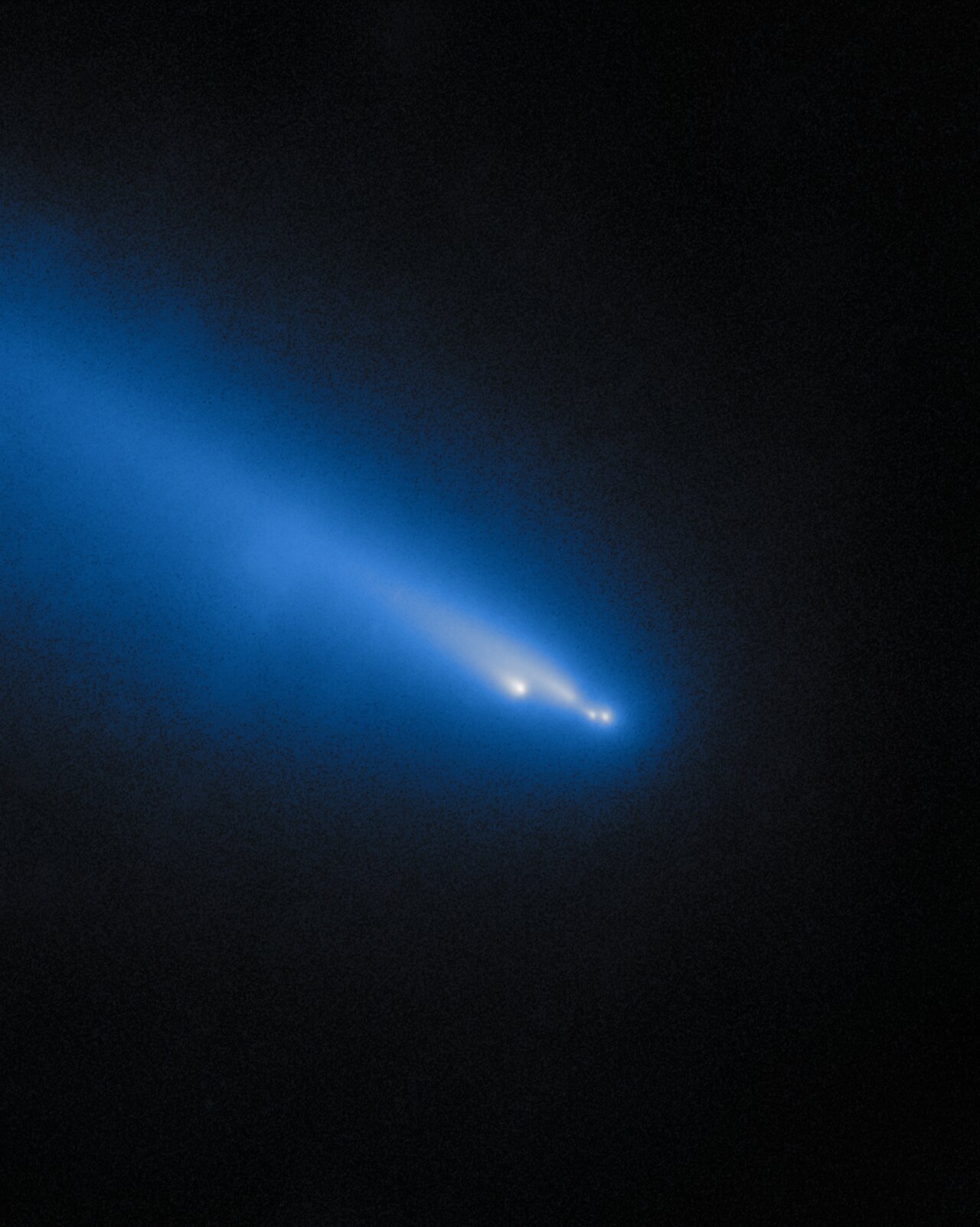
Intuitive Machines targeting January 2025 for launch of its next lunar lander

The landers either at or targeting the Moon's south pole
The landers either at or targeting the Moon’s south pole

The company Intuitive Machines is now aiming to launch its second Nova-C lunar lander, dubbed Athena, during a January 1-5, 2025 launch window.

The landing site is indicated on the map to the right, on the rim of Shackleton crater and almost on top of the south pole. While Chang’e-7 is targeting the same crater rim, it is not scheduled for launch until 2026.

The lander will not only include a drill for studying the surface below it, it will release a small secondary payload, the Micro-Nova Hopper, which will hopefully hop down into the permanently shadowed craters nearby.

The launch will also carry a lunar orbiter, dubbed Lunar Trailblazar, which will not only do spectroscopy of the lunar surface, looking for water, it will also be used as a communications relay satellite with Athena. That orbiter, designed to demonstrate the ability to build a smallsat at low cost, was previously threatened with cancellation because its builder, Lockheed Martin, went way over budget.

New gravity map of Mars released

New global map of Mars gravity field
Click for original image.
Using both seismological data compiled over four years by the InSight Mars lander as well tiny changes in the orbits of Martian satellites, scientists have now created a global gravity map of the red planet, indicating the regions below the surface that are either low or high density.

That map is above, annotated by me to indicate some of Mars’ major surface features.

The density map shows that the northern polar features are approximately 300-400 kg/m3 denser than their surroundings. However, the study also revealed new insights into the structures underlying the huge volcanic region of Tharsis Rise, which includes the colossal volcano, Olympus Mons.

Although volcanoes are very dense, the Tharsis area is much higher than the average surface of Mars, and is ringed by a region of comparatively weak gravity. This gravity anomaly is hard to explain by looking at differences in the martian crust and upper mantle alone. The study by Dr Root and his team suggests that a light mass around 1750 kilometres across and at a depth of 1100 kilometres is giving the entire Tharsis region a boost upwards. This could be explained by huge plume of lava, deep within the martian interior, travelling up towards the surface.

I once again note that the largest impact basin on Mars, Hellas Basin, sits almost exactly on the planet’s far side from Tharsis, and appears to have a light density. This contrast once again makes me wonder if the origin of that impact and the Tharsis Bulge are linked.

A fluted mesa on Mars

A fluted mesa on Mars
Click for original image.

Cool image time! The picture to the right, cropped, reduced, and sharpened to post here, was taken on July 9, 2024 by the high resolution camera on Mars Reconnaissance Orbiter (MRO). It shows what the science team labels a “silica-rich mound”, as indicated by the bright streaks on all the high ridge points.

The flat-topped mesa on the right drops about 200 feet to the valley floor. The rims of that depression to the west rise about 50+ feet higher, while mesa nose in the upper left rising another 50+ feet more.

Was the depression caused by an impact? If so, the landscape has changed radically since that impact occurred, with most of the surrounding terrain eroded away. The two flat-topped mesas hint at the ancient surface when that impact occurred.

A wider view however raises questions about this impact theory.
» Read more

Scientists re-create on Earth the sublimation of Mars’s winter mantle of dry ice

Spiders created on Earth
Click for original image.

Scientists have successfully re-created on Earth the process on Mars that creates the unique “spider” formations seen in the the Martian south pole region, produced when the winter mantle of dry ice begins to sublimate away into a gas.

The study confirms several formation processes described by what’s called the Kieffer model: Sunlight heats the soil when it shines through transparent slabs of carbon dioxide ice that built up on the Martian surface each winter. Being darker than the ice above it, the soil absorbs the heat and causes the ice closest to it to turn directly into carbon dioxide gas — without turning to liquid first — in a process called sublimation (the same process that sends clouds of “smoke” billowing up from dry ice). As the gas builds in pressure, the Martian ice cracks, allowing the gas to escape. As it seeps upward, the gas takes with it a stream of dark dust and sand from the soil that lands on the surface of the ice.

At the south pole, the ground below the mantle is stable enough that each winter the trapped CO2 gas follows the same path to the same points where the dry ice cracks, slowly creating “tributaries” that combine to form the spider formations.

The picture to the right, cropped, reduced, and sharpened to post here, comes from figure 9 of the paper [pdf]. It shows the lab-created spiders formed by this simulated process, thereby confirming this hypothesis about how the spiders form.

Ispace targeting a December launch for its second attempt to softland on the Moon

Landing zone for Resilience lander

At a press conference yesterday officials of the Japanese company Ispace announced that they are now targeting a December 2024 launch of their second Hakuto-R lunar lander, dubbed “Resilience”, with the landing site located in the high mid-latitudes of the near-side of the Moon.

The map to the right indicates that location, inside Mare Frigoris. Atlas Crater is where Ispace attempted but failed to soft land its first lunar lander, Hakuto-R1, in April 2023.

This new lander will be launched on a Falcon 9 rocket. It carries six commercial payloads. It also appears the company decided to go for an easier landing site on this second mission. Rather than try to land inside a crater, it is targeting a very large and flat mare region, thus reducing the challenges presented to its autonomous software.

Ispace already has contracts both with NASA ($55 million) and Japan’s JAXA space agency ($80 million) for two more future landers, so a successful landing this time is critical to the company’s future.

A map of Io’s hot spots based on Juno data

The hot spots on Io
Click for original image.

The uncertainty of science: Using the JIRAM infrared camera on the Jupiter orbiter Juno, scientists have now created a global map of volcanic activity, showing where it appears the hottest and greatest activity is located.

That data is illustrated by the graphic to the right, taken from figure 1 of the paper. The top row shows the coverage of the planet, with Io’s southern hemisphere getting the fewest observations. The bottom row shows the observed regions with the greatest heat. This quote from the abstract is most revealing:

Using JIRAM, we have mapped where volcanoes are producing the most power and compared that to where we expect higher heat flow from the interior models. Our map doesn’t agree with any of these models very well. JIRAM observed more volcanic activity at the poles than we expected to see based on previous observations. However, since the south pole was only observed twice, it’s possible that these observations don’t represent the average volcanic activity of the south pole. Very bright volcanoes that may have been continuously active for decades were also imaged during these Juno fly-bys, some of which are nearer the poles than the equator.

The conflict between the data and the theories could very well be explained simply by the short term nature of these observations. The models could very well be right, over centuries. For example, the new volcano discovered by Juno is near the equator, suggesting with time those models will turn out to be correct.

Or not. A lot more observations will have to be made of Io before any model of its volcanic activity can be considered trustworthy.

Juno discovers new volcano on Io

New volcano on Io
Click for original image.

By comparing images taken twenty-seven years apart by the the Jupiter orbiters Galileo and Juno, scientists have discovered that during that time a new volcano appeared on the volcano-strewn Jupiter moon Io.

The two pictures to the right show the surface change on Io during those 27 years.

Analysis of the first close-up images of Io in over 25 years, captured by the JunoCam instrument on NASA’s Juno mission, reveal the emergence of a fresh volcano with multiple lava flows and volcanic deposits covering an area about 180 kilometres by 180 kilometres. The findings have been presented at the Europlanet Science Congress (EPSC) in Berlin this week.

The new volcano is located just south of Io’s equator. Although Io is covered with active volcanoes, images taken during NASA’s Galileo mission in 1997 did not see a volcano is in this particular region – just a featureless surface.

If anything, it has been somewhat surprising how little change the new Juno images have found on Io’s surface, considering its intensely active volcanic geology, with volcano plumes from eruptions captured in images repeatedly. Some volcanoes have shown change, but new features such as this new volcano have not previously been identified.

At the same time, the amount of high resolution imagery of the planet’s surface has been somewhat limited. Galileo sent back far fewer pictures than planned because its main antenna never deployed, and Juno had only a handful of close fly-bys. It will take a mission dedicated to studying Io to better map its violent surface.

Engineers successfully switch thrusters on Voyager-1

The Voyager missions
The routes the Voyager spacecraft have
taken since launch.

Because of an increasing number of clogged thrusters on the almost half-century old Voyager-1 spacecraft, now flying just beyond the heliosphere of the solar system, engineers needed to switch thrusters recently, and successfully did so in a complex dance of engineering.

They had to switch from one thruster, in which a fuel line has become increasingly clogged in the last few years due to age, to an another thruster in a different system. The switch however required other careful preparations, since Voyager-1’s nuclear power supply has dropped to a point where they have been forced to shut down almost all operations. Thus, the thrusters are not getting heated as they once were, and turning on the replacement thruster in this condition could damage it.
» Read more

The reasons why Mars two polar caps are so different

The Martian north pole
The Martian north pole.

The Martian south pole
The Martian south pole.

Elevation scale bar
What the colors mean in terms of elevation

A new paper, in review for the past year, has now been published describing the differences between the north and south poles of Mars, the most fundamental of which involve the planet’s orbit and the different elevations of the two poles, with the south pole three to six miles higher in altitude (as indicated by the colors on the maps to the right).

The cumulative data has allowed the researchers to explain why — when the thin winter cap of dry ice sublimates away in the spring — the process at the south pole results in spiderlike features that get enhanced from year to year, but in the north pole that sublimation process produces no such permanent features.

In both cases, the spring sunlight passes through the clear winter mantle of dry ice to heat its base. The sublimated trapped CO2 gas builds up, until the pressure causes the mantle to crack at weak spots. In the south that trapped gas flows uphill each spring along the same paths, carving the riverlike tributaries dubbed unofficially as “spiders” and officially as “araneiform terrain.”

Geophysicist Hugh Kieffer described that process in 2006. A few years later, [Candice] Hansen [the new paper’s lead author] followed up with her own model for the north polar cap, which also displays fans in the spring.

She found that the same phenomena occur in the north, but rather than relatively flat terrain, these processes play out across sand dunes. “When the Sun comes up and begins to sublimate the bottom of the ice layer, there are three weak spots – one at the crest of the dune, one at the bottom of the dune where it meets the surface and then the ice itself can crack along the slope,” Hansen said. “No araneiform terrain has been detected in the north because although shallow furrows develop, the wind smooths the sand on the dunes.”

There is also a lot more dust in the north, including a giant sea of dunes that circles the polar cap. In addition, the northern winter is shorter due to the planet’s orbit, and takes place during the annual dust storm season, causing there to be more dust concentrated within the northern ice. All of these factors make the the dunes and general surface in the north is more easily smoothed by the wind.

A cloud atlas of Mars

Different clouds on Mars interacting
Click for original image.

Using data obtained from one of the instruments on the European Space Agency’s (ESA) Mars Express orbiter, scientists have now published an atlas of the clouds of Mars and made it available to the public.

The picture to the right, cropped, reduced, and sharpened to post here, is just one example of the images in the atlas. From the caption:

This image displays two atmospheric phenomena: the white curved lines are gravity wave clouds, while the brown areas are dust lifted from the ground by wind. The colour shift visible in the dust lifting event might be indicative of very fast winds, a phenomenon currently under investigation by other members of the team.

The atlas contains more than 300 images of various Martian cloud formations, from the one to the right to images of cirrus clouds on the top of Olympus Mons, Mars’ largest volcano. You can download it here (the file is a very large spreadsheet).

In approving Europa Clipper’s launch, NASA and JPL claim its non-spec transistors will “heal” themselves in Jupiter orbit

Europa in true color
Europa in true color, taken by Juno September 2022.
Click for full image.

In making the decision to allow Europa Clipper to be launched on a Falcon Heavy on October 10, 2024, NASA and JPL officials explained that after several months of testing, they believe the improperly hardened transistors installed throughout the orbiter will “heal” themselves while in the low radiation portions of its orbit around Jupiter.

[The testing] showed the transistors in question will, in effect, heal themselves during the 20 days between the high radiation doses the probe will receive during each of 49 close flybys of Europa, all of them deep in Jupiter’s powerful magnetic field and radiation environment.

In addition, onboard heaters can be used as needed to raise the temperature of affected transistors, improving the recovery process. “After extensive testing and analysis of the transistors, the Europa Clipper project and I personally have high confidence we can complete the original mission for exploring Europa as planned,” said Jordan Evans, Europa Clipper project manager at NASA’s Jet Propulsion Laboratory.

I hope this analysis is right, though I fear there is a lot of wishful-thinking involved. It could be however that this testing, in combination with what engineers have learned during Juno’s so-far 64 orbits around Jupiter, might have reassured them.

We however will not know for sure until Europa Clipper is on its way and reaches Jupiter in 2030.

A crack on Mars more than 600 miles long

A crack on Mars more than 600 miles long
Click for original image.

Cool image time! The picture to the right, cropped and reduced to post here, was taken on March 29, 2024 by the high resolution camera on Mars Reconnaissance Orbiter (MRO).

The science team labels this “troughs in Labeatis Fossae.” On Mars, the word “fossae” is used to indicate regions where there are a lot of parallel fissures. Though there are a few examples where such fissures might have been caused by the movement of ice or water, carving out the channel, in almost all cases this is not the cause. Instead, fossae are usually formed when the surface stretches, either because underground upward pressure pulls it apart, or because there is a sideways spread at the surface. The resulting cracks are generally considered what geologists call “grabens,” depressions caused at faultlines when the ground on either side moves apart in some manner.

In this case the break in the trough proves this is a graben, though why it broke at this spot is not clear.
» Read more

Musk: First unmanned Mars Starship targeting a ’26 launch

The prime and secondary Martian landing sites for Starship

According to a tweet yesterday by Elon Musk, SpaceX is aiming for a 2026 launch of its first unmanned Starship to Mars.

The first Starships to Mars will launch in 2 years when the next Earth-Mars transfer window opens. These will be uncrewed to test the reliability of landing intact on Mars. If those landings go well, then the first crewed flights to Mars will be in 4 years.

Flight rate will grow exponentially from there, with the goal of building a self-sustaining city in about 20 years.

The graphic to the right indicates the planned landing zone, with the four red dots the four prime locations. Three of the four are very flat, though they also appear to have a lot of very near-surface ice, accessible simply by digging a shovel into the ground. Attempting to land at any will definitely test Statship’s ability to land on Mars intact. A global map of Mars is shown below, showing the location of this landing zone. The map shows where researchers believe the saltiest water on Mars would be. According to this data, in the Starship landing zone some of that near-surface ice will turn to liquid brine a little less than one percent of each year. Otherwise it will be more easily processed for drinking and fuel.

As always with these ambitious predictions, Musk is aiming high, with the likelihood that this first mission will not make that ’26 date. At the same time, he is making it very clear that a first attempt will certainly happen by ’28.

I also think the timing of this announcement is intriguing, coming one day after NASA was forced to cancel the launch in October of two Mars orbiters because it could not be certain Blue Origin would have the New Glenn rocket ready on time. Musk’s response is to say that SpaceX is now about to begin regularly privately funded and privately built missions to Mars, on a schedule, essentially asking: “Which company would you choose to do things in space?”
» Read more

NASA cancels launch of its two Escapade Mars Orbiters due to Blue Origin delays

After reviewing the status of launch preparations by Blue Origin of its New Glenn rocket, NASA today decided to cancel the launch because it appeared that Blue Origin would not be able to meet the October 13-21 launch window for sending the agency’s two Escapade orbiters to Mars.

NASA announced Friday it will not fuel the two ESCAPADE (Escape and Plasma Acceleration and Dynamics Explorers) spacecraft at this time, foregoing the mission’s upcoming October launch window. While future launch opportunities are under review, the next possible earliest launch date is spring 2025.

The agency’s decision to stand down was based on a review of launch preparations and discussions with Blue Origin, the Federal Aviation Administration, and Space Launch Delta 45 Range Safety Organization, as well as NASA’s Launch Services Program and Science Mission Directorate. The decision was made to avoid significant cost, schedule, and technical challenges associated with potentially removing fuel from the spacecraft in the event of a launch delay, which could be caused by a number of factors.

The press release of course is vague about why the launch has been canceled, but the reasons are obvious if you have been paying attention. Though Blue Origin has clearly been making progress towards the first launch of New Glenn, recent reports suggested strongly that it would be impossible for it to assemble the rocket, integrate the two orbiters, and get everything on the launchpad on time.

Rocket Lab, which built the orbiters, of course fully supported the decision, though that company very much wanted it to fly now to demonstrate its ability to make low cost smallsat planetary probes.

This failure of Blue Origin to meet this deadline speaks poorly of the company. To serve the satellite and especially the planetary research community rocket companies must be able to launch on schedule and on time. Blue Origin has failed to do so in this case. It appears Jeff Bezos needs to ramp up the pressure on his moribund company to finally get it to perform in the manner he desires, as described by Bezos himself recently.

Dust storm in Jezero Crater

Overview map
Click for interactive map.

Dust storm in Jezero Crater
Click for original image.

An update today from the science team for the Mars rover Perseverance included the picture to the right, cropped, reduced, and sharpened to post here and taken by the rover on August 20, 2024. As the update noted,

It is dust-storm season on Mars! Over the past couple of weeks, as we have been ascending the Jezero Crater rim, our science team has been monitoring rising amounts of dust in the atmosphere. This is expected: Dust activity is typically highest around this time of the Martian year (early Spring in the northern hemisphere). The increased dust has made our views back toward the crater hazier than usual, and provided our atmospheric scientists with a great opportunity to study the way that dust storms form, develop, and spread around the planet.

The yellow lines on the overview map above indicate the approximate direction of the photo. The blue dot marks Perseverance’s present position, with the red dotted line its planned route and the white dotted line its actual travels.

At the moment this dust storm is localized to the region around Jezero Crater, and based on past seasonal dust storms, is not expected to expand to a global storm.

ESA releases images taken by BepiColombo during Mercury fly-by

Mercury as seen by BepiColombo September 4, 2024
Click for original image.

The European Space Agency (ESA) yesterday released images taken by the BepiColombo probe as it completed its fourth fly-by of Mercury on its long journey to enter orbit around that planet.

The picture to the right, cropped, reduced, and sharpened to post here, was taken four minutes after the closest approach of about 103 miles.

Four minutes after closest approach, a large ‘peak ring basin’ came into BepiColombo’s view. These mysterious craters – created by powerful asteroid or comet impacts and measuring about 130–330 km across – are called peak rings basins after the inner ring of peaks on an otherwise flattish floor.

This large crater is Vivaldi, after the famous Italian composer Antonio Vivaldi (1678–1741). It measures 210 km across, and because BepiColombo saw it so close to the sunrise line, its landscape is beautifully emphasised by shadow. There is a visible gap in the ring of peaks, where more recent lava flows have entered and flooded the crater.

BepiColombo still has two more fly-bys of Mercury to do before entering orbit in November 2026. At that time the spacecraft’s two orbiters, one from Europe and the other from Japan, will separate and take up complementary orbits.

Curiosity takes another look south into Gediz Vallis

Looking south inside Gediz Vallis

Overview map
Click for interactive map.

Cool image time! As it has been more than a month since I lasted posted a cool landscape image from the Mars rover Curiosity, it seemed time to upload the panorama above, changed not at all to post here and taken by the rover’s right navigation camera on September 4, 2024.

The blue dot on the overview map to the right marks Curiosity’s present position. The yellow lines indicate the approximate direction of the panorama’s view. The red dotted line indicates Curiosity’s planned route, with the white dotted line marking its actual path. After spending most of the last month on a drilling campaign at the southernmost point of its travels, the science team had Curiosity retreat northward, where it will eventually head uphill to the west to swing around that mountain to head south in a parallel canyon.

The panorama looks into the slot canyon Gediz Vallis that Curiosity has been exploring for a little more than a year. The light colored mountains are what the scientists call the sulfate-bearing unit, a region on the higher slopes of Mount Sharp that is likely to have a very alien geology and chemistry, when compared to what is seen on Earth. Mount Sharp itself is beyond these peaks, not visible because it is about 26 miles away and blocked by these lower mountains.

Since landing on Mars a dozen years ago, the rover has traveled 20 miles and climbed about 2,500 feet. Getting to the top of Mount Sharp will therefore probably take more than one or two decades more of travel.

Mars loses hydrogen at very different rates, depending on the planet’s distance from the Sun

Hubble uv images of Mars atmosphere
Click for original image.

Scientists using data from both the MAVEN Mars Orbiter and the Hubble Space Telescope have determined that the rate in which Mars loses hydrogen and deuterium varies considerably during the Martian year, with the rate going up rapidly when the red planet reaches its closest point to the Sun. The picture to the right, reduced to post here, shows the data from Hubble.

These are far-ultraviolet Hubble images of Mars near its farthest point from the Sun, called aphelion, on December 31, 2017 (top), and near its closest approach to the Sun, called perihelion, on December 19, 2016 (bottom). The atmosphere is clearly brighter and more extended when Mars is close to the Sun.

Reflected sunlight from Mars at these wavelengths shows scattering by atmospheric molecules and haze, while the polar ice caps and some surface features are also visible. Hubble and NASA’s MAVEN showed that Martian atmospheric conditions change very quickly. When Mars is close to the Sun, water molecules rise very rapidly through the atmosphere, breaking apart and releasing atoms at high altitudes.

From this data scientists will be better able to map out the overall loss rate of water on Mars over many billions of years.

China significantly expands its international partners for its planetary program

According to China’s state-run press, it has recently signed cooperative agreements with a significant number of new nations for either its International Lunar Research Station project (ILRS) or other deep space planetary missions.

During the opening ceremony of a two-day space conference held in Tunxi, east China’s Anhui Province on Thursday, the China National Space Administration (CNSA) and its counterpart in Senegal signed an agreement on International Lunar Research Station (ILRS) cooperation.

At the conference, China’s Deep Space Exploration Lab (DSEL) inked memoranda of understanding with 10 institutions from countries including Serbia, Switzerland, the United Arab Emirates, Indonesia, Pakistan, Panama and South Africa. Also among the institutions are the Belt and Road Alliance for Science & Technology, the Foundation for Space Development Africa, and Africa Business Alliance.

Senegal is now the thirteenth nation to join China’s lunar base project, following Azerbaijan, Belarus, Egypt, Kazakhstan, Nicaragua, Pakistan, Russia, Serbia, South Africa, Thailand, Turkey, and Venezuela. That partnership also includes about eleven academic or governmental bureaucracies.

The agreements involving China’s deep space exploration involve other missions to other planets, with those nations either providing science instruments or some other contribution. That Switzerland and the United Arab Emirates have signed deals suggests there is a rising desire in the west to team up with China because of its general success in space, compared to the problems other nations often experience when dealing with NASA and the U.S. If so, the competition will certainly heat up in the coming years. I hope in this competition that American private enterprise can make up for the failures of our government.

Amateur astronomer detects changes in the reflective light coming off of NASA’s orbiting solar sail

Observations by amateur astronomer Marco Langbroek of Delft Technical University in the Netherlands has detected significant changes in the reflective light coming off of the giant orbiting solar sail that NASA engineers recently deployed in orbit.

I observed the Solar Sail again in the evening of September 1, 2024, and this time the brightness of the Solar Sail was quite different. As it rose in the south, it became very bright, reaching magnitude 0 (as bright as the brightest stars in the sky). It then faded again, and next displayed a slow brightness variation with multiple bright maxima and very faint minima.

…The brightness seems to indicate a slow cycle of around half a minute. … The brightness variation could be suggestive of a slow tumble or wobble (a gyration around an axis) that must have been initiated after August 29, when it appeared more steady (apart from a brief bright flare, probably due to a favourable sun-sail-observer geometry).

The sail, dubbed the Advanced Composite Solar Sail System, was launched on April 23rd, and after some initial technical issues it was deployed from its small cubesat on August 30th, expanding to 860 square feet.

The changes Langbroek detected have all occurred after that deployment, and suggest one of two things. Either the NASA engineers are testing the sail’s maneuverability, as planned, and thus the sunlight reflecting off it changes, or there is a problem controlling it that NASA has not yet revealed. We will have to wait to find out.

China targets 2028 for its own Mars sample return mission

According to a report today in China’s state-run press, it now hopes to launch its own Mars sample return mission in 2028, dubbed Tianwen-3.

The report is very vague about the missions design. It notes that it will involve two launches, including “key technologies such as collecting samples on the Martian surface, taking off from the Red Planet, [and] rendezvous on the orbit around Mars.”

Based on China’s overall track record for its planetary program, it is likely that the launch will likely take place somewhat close to this schedule, though a delay of one or two years would not be unreasonable. If so, we are looking at either two or three different projects to bring Mars samples back to Earth at almost the same time.

The first is the NASA/ESA joint Mars sample return mission, which is presently far behind schedule with large cost overruns, all because the mission design has been haphazard and confusing. At the moment it involves an American lander, a European orbiter and return capsule, a Mars launch rocket to be built by Lockheed Martin, and at least one Mars helicopter. None of this however is certain, as NASA is right now asking industry for suggestions for redesigning the mission. It is presently hoping to bring its samples back sometime in the 2030s.

The second is this China mission, which appears to have some of the same planned components, which is not surprising considering China’s habit of copying or stealing other people’s ideas.

A third sample return mission might also be flown, by SpaceX using its Starship spaceship and Superheavy rocket. Both are built with Mars missions specifically in mind. SpaceX has also ready done work locating a preliminary landing zone. If so, it could possible attempt this mission at about the same time, independent of both China or NASA.

Or it might simply offer Starship as part of the redesigned NASA sample return mission. There is also the chance SpaceX would do both.

If I had to bet, I would say SpaceX (on its own) is the most likely to do this first, with China second. If SpaceX teams up with NASA then it will be a close race between NASA and China.

NASA confirms Europa Clipper launch on October 10, 2024 with questionable transistors

NASA yesterday confirmed that it has decided to go ahead with the October 10, 2024 launch of its $5+ billion Europa Clipper mission to Jupiter, despite the installation of transistors on the spacecraft that the agency knows are not properly hardened for that harsh environment.

Those transistors were built by a German company as part of equipment used by the spacecraft’s electrical system. Apparently that company hired a subcontractor to furnish the transistors, which failed to make them to the right specifications. Subsequent testing found that it is quite likely that at least some of the transistors will fail when Europa Clipper reaches Jupiter orbit.

It appears that NASA decided that the issue risk was small enough for the mission to achieve its minimal expected results, and decided the cost of delay and bad publicity replacing the transistors before launch would be worse than the limited science payoff and bad publicity that would take place years hence, when those transistors fail.

Remember this story in in 2030 when Europa Clipper enters Jupiter orbit and begins to experience problems.

A channel of ice, water, or lava?

A channel of ice, water, or lava?
Click for original image.

Cool image time! The picture to the right, rotated, cropped, reduced, and sharpened to post here, was taken on July 16, 2024 by the high resolution camera on Mars Reconnaissance Orbiter (MRO). It shows one small section of a Martian canyon approximate 750 miles long and dubbed Elysium Fossae.

The canyon walls at this spot rise about 3,300 to 3,800 feet from the canyon floor. The canyon itself is thought to be what geologists call a graben, initially formed when the ground was pulled apart to form a large fissure.

That’s what happened at this location, at least to start. This canyon is on the lower western flank of the giant shield volcano Elysium Mons. The cracks, which radiate out outward from the volcano’s caldera, likely formed when pressure from magma below pushed upward, splitting the surface.

That formation process however does not fully explain everything.
» Read more

NASA asks space industry for proposals on using the shelved Janus probes on mission to Apophis

NASA has now put out a request for proposals from the space industry for refitting the two Janus planetary probes, whose asteroid mission was shelved when its launch as a secondary payload was delayed due to problems with the Psyche primary payload, as a mission to the asteroid Apophis in connection with its April 13, 2029 close approach to the Earth.

NASA has been studying this new mission goal since early 2023, but apparently had failed to come up with a plan. It is now asking the private sector for suggestions on getting it done, including finding the funding for any plans.

Russia claims its next unmanned Moon mission, Luna-26, is on schedule

Phase I of China/Russian Lunar base roadmap
The original phase I plan of Chinese-Russian lunar
base plan, from June 2021.

According to Russia’s state-run press, its next unmanned Moon mission, Luna-26, is on schedule for a planned launch in 2027, though that press also claims the launch may happen in 2026 instead.

The problem with this claim is that Russia had for years said that this lunar orbiter would launch by 2025. As expected, the mission has not launched on time, as have all of Russia’s 21st century lunar exploration plans. For example, the previous lunar mission, the Luna-25 lunar lander, was originally supposed to land on the Moon in 2021, was not launched until 2023, and ended up crashing on the Moon when the spacecraft did not function properly during a engine burn in lunar orbit.

In the first phase of the so-called China-Russian partnership to explore the Moon, is shown by the 2021 graph to the right, China continues to do all the heavy lifting, and do so pretty much on the schedule predicted. Russian meanwhile continues to do what I predicted back in 2021, get nothing done on time and when launched have problems.

A frozen Martian splash

A frozen Martian splash
Click for original image.

Cool image time! The picture to the right, rotated, cropped, and enhanced to post here, was taken on July 11, 2024 by the high resolution camera on Mars Reconnaissance Orbiter (MRO). It shows the southeast quadrant of a three-mile-wide unnamed crater that is surrounded on all sides by a dramatic but frozen splash apron of material, created when this impact occurred.

The rim rises between 200 to 400 feet from the surrounding plains, while the crater floor drops 700 feet to sit below those plains by 300 to 500 feet. In other words, that splash apron contains the material that was thrown up when the bolide drilled into the plain at impact, leaving behind this deep hole.

Why such a dramatic splash apron? Its existence suggests that the ground here was muddy, with a lot of water ice likely present. The location and wider context helps confirm this guess.
» Read more

Two-lobed asteroid imaged by radar

Two-lobed asteroid
Click for original image.

During the August 18, 2024 first close fly-by of a potentially-dangerous asteroid only discovered back in May, astronomers used the Goldstone dish in California to produce the high resolution radar images shown in the picture to the right, reduced and sharpened to post here.

The images were captured when the asteroid was at a distance of 2.8 million miles (4.6 million kilometers), about 12 times the distance between the Moon and Earth.

Discovered by the NASA-funded Catalina Sky Survey in Tucson, Arizona, on May 4, the near-Earth asteroid’s shape resembles that of a peanut – with two rounded lobes, one lobe larger than the other. Scientists used the radar images to determine that it is about 980 feet (300 meters) long and that its length is about double its width. Asteroid 2024 JV33 rotates once every seven hours.

Asteroids formed as contact binaries, once considered the stuff of science fiction, have now been found to be relatively common, comprising about 14% of the near Earth asteroids larger than 700 feet across that have been radar-imaged. The refined orbital data suggests this asteroid might be a dead comet, though that conclusion is unconfirmed. That orbital data also tells us that though this object has the potential of hitting the Earth, it will not do so “for the foreseeable future.”

Scientists find oldest known reference to a solar eclipse dated approximately 6,000 years ago

In studying an ancient Hindu text called the Rig Veda that was compiled around 1,500 BC, scientists have found what they think is the oldest known reference to a solar eclipse, dated approximately 6,000 years ago.

You can read the peer-reviewed paper here [pdf]. From the paper’s conclusion:

We propose that the eclipse recorded in the Rig Veda refers to observations made of an eclipse around 4000 BC. By analyzing the description, we propose that the eclipse was the one that occurred in 4202 BC or else in 3811 BC. We propose that it was observed in Central Asia. To our knowledge, this is one of the oldest known references to a specific total solar eclipse mentioned in the historical literature.

The scientists came to this conclusion based on information contained and not contained in the Hindu text. The text noted the event occurred three days before the autmnal equinox, and that it occurred when that equinox occurred in the constellation Orion, when today the equinox occurs in the constellation Pisces. This reduced the number of possible eclipses to a small number during the time period around 4,000 BC. The text also lacked any mention of various Hindo myths explaining eclipses that appeared more recently, thus confirming this ancient date and telling the researchers that the nomadic people who compiled the Rig Veda were likely living in central Asia at that time.

The only two eclipses that fit the bill occurred on either October 22, 4202 BC or October 9, 3811 BC. This makes it the earliest known reference to an eclipse, far earlier than the possible eclipses that occurred in around 3340 BC and around 1300 BC.

Sunspot update: The Sun continues to boom!

It is time for my monthly sunspot update, taking NOAA’s most recent update of its monthly graph tracking the number of sunspots on the Sun’s Earth-facing hemisphere and adding my own analysis as well as some additional details to provide the larger context.

During August the Sun continued to confound the experts, with the number of sunspots not only greater than July’s high count. the August count exceeded the numbers from December 2001 (215.5 vs 213.4), the last time the Sun was this active.

None of the predictions by anyone in the solar science community had predicted this level of activity.
» Read more

A galaxy with a halo and a stupendous central black hole

A galaxy with a halo and a stupendous black hole
Click for original image.

Cool image time! The picture to the right, cropped, reduced, and sharpened to post here, was taken by the Hubble Space Telescope as part of a survey of galaxies that have what astronomers call active galactic nuclei (AGNs). This galaxy, dubbed IC 4709, is about 240 million light years away.

If IC 4709’s core were just filled with stars, it would not be nearly so bright. Instead it hosts a gargantuan black hole, 65 million times the mass of our Sun. A disc of gas spirals around and eventually into this black hole, with the gas crashing together and heating up as it spins. It reaches such high temperatures that it emits vast quantities of electromagnetic radiation, from infrared to visible to ultraviolet light and beyond — in this case including X-rays. The AGN in IC 4709 is obscured by a lane of dark dust, just visible at the centre of the galaxy in this image, which blocks any optical emission from the nucleus itself.

To get a very vague sense of scale, this supermassive black hole is more than sixteen times more massive than the relatively inactive supermassive black hole in the center of the Milky Way. This imagery and data from Hubble will help astronomers better understand the interaction between the black hole and its surrounding galaxy.

1 9 10 11 12 13 276