My personal GP doctor in Arizona, Robert Lending, has for the last year sent out weekly detailed updates to his patients on the on-going COVID-19 epidemic. I thought I provide my readers his carefully researched doctor’s perspective, with his permission of course.
First he updates us on the state of the epidemic in Arizona:
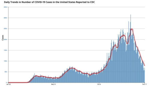
The surge in AZ and in Pima County is over; with dramatic decreases in Cases, Case Fatality Rates (CFR), and Case Hospitalization Rates (CHR). The hospitalization utilizations including beds and ventilators, etc. are markedly decreased. {{{Tucson Medical Center is down to 10.5% Inpatient Covid-19, and they will resume elective surgeries.}}} The initial reductions began before vaccinations, but now may have been helped by the vaccinations. On the other hand, the virus acts as it will; independent of most of society’s attempts to control or modify it, no matter what the politicians and health department officials state. [emphasis mine]
The highlighted text matches what I have been saying for the past year, that the panicky effort to “stop the spread of COVID-19” was foolish, counterproductive, and entirely useless. And the evidence now a year later supports that conclusion. Nothing done by any government anywhere in the world has stopped the virus from spreading, whether it be lockdowns, masks, or quarantines. In the U.S. and Europe especially places that imposed fewer restrictions on their citizens seemed to fare about the same as places where the government stamped down hard. And those former places also had less negative consequences for their economies and for the freedoms of their citizens.
Meanwhile, the evidence is that the epidemic in Arizona is fading. And as far as I can see, during its height it affected almost no one in the general population. Like the flu it impacted the elderly sick the most, but everyone else either didn’t see it at all, or if they got sick they almost always recovered.
Unfortunately, it doesn’t matter that the epidemic is fading and that a vaccine is now available. The unreasonable rules imposed during the panic remain in force, and likely will never go away. And I speak from experience. For example, in trying to schedule an appointment with another doctor, I was told by his office that even if I had tested negative for COVID, received the vaccine, and quarantined myself between its receipt and my appearance at the office, I would still be required to wear a mask.
Think about that. I would be totally healthy and have no symptoms and could in no way transmit the virus, and yet the mask would still be required. We are now a society that irrationally sees all other humans as a threat to be avoided, at all times.
As for the flu, Lending noted some very intriguing data.
» Read more


