
Eroded and possibly wet Lohse Crater
Click for full image.
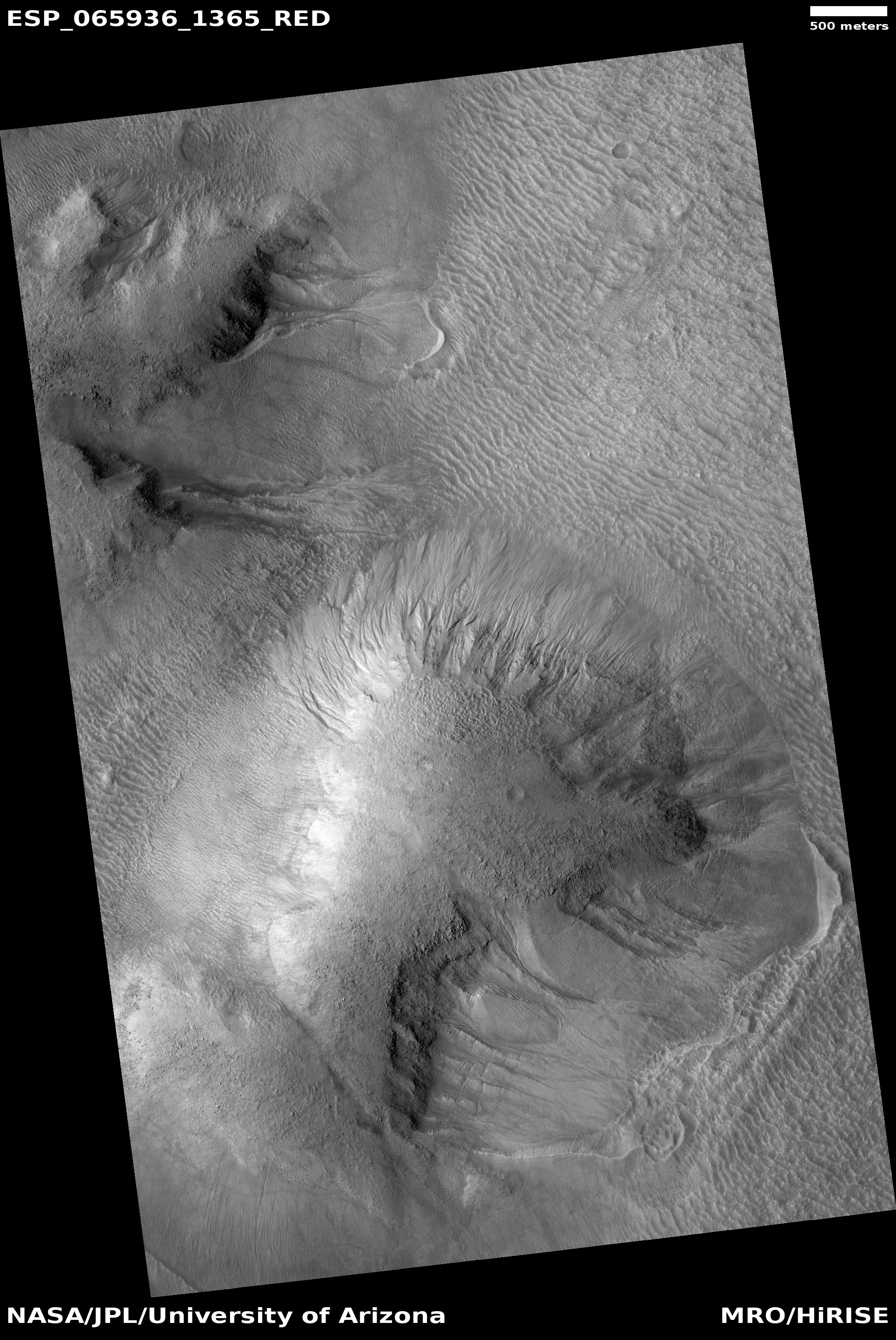
Cool image time! Today we take a look at one particular 100-mile-wide crater, Lohse Crater, located in the southern cratered highlands on Mars. The photo to the right, cropped and reduced to post here, focuses in on one of the many eroding gullies found in the mountainous region surrounding the crater’s central peak. Taken on August 20, 2020 by the high resolution camera on Mars Reconnaissance Orbiter (MRO), the full image is centered on that central peak, just off the south edge of this cropped section. This new image is part of a long monitoring campaign, begun in 2007, of this central peak region. For more than six Martian years, scientists have been tracking the numerous gullies found throughout the central peak region to see if there have been any changes.
I focused on this specific gully because I think it illustrates well why planetary scientists are monitoring these gullies. Whatever flowed down from the cliff on the left hit the material on the right hard enough and fast enough to imprint a curve into the material on the crater floor. Moreover, it does not appear to have simply been a landslide, for several reasons. First, the cliff does not appear cut back at the flow’s head, as you would expect if a section had broken off. Second, the material in the flow does not look like debris from an avalanche. In fact, there does not appear to be very much debris in the gully at all.
Third, and most important, the flow appears to originate at the cliff base, kind of what you’d expect if there was seepage coming out of a layer in that cliff face. Kind of what you’d expect on Earth, at a spring!
Was that flow water? This is the big question. Lohse Crater is significant in that it was one of the first locations on Mars [pdf] spotted by Mars Global Surveyor in the late 1990s where gullies were found suggesting some form of regular erosion possibly caused by flowing water. As this 2005 paper then concluded,
[T]he features documented in this study are best explained by surface accumulation of snow, followed by melting and runoff.
In the decade and a half since much new data has helped refine this conclusion. As noted in the caption for a 2009 MRO hi-res image of Lohse’s central peak gullies,
Gullies are present on many slopes on Mars, especially between the latitudes of 30 and 70 degrees in both hemispheres. Gullies are formed by fluids and have three distinct parts to them: an eroded “alcove” at the top, a sometimes sinuous “channel” section, and finally a large “debris apron” where the material eroded by the gully is deposited. [emphasis mine]
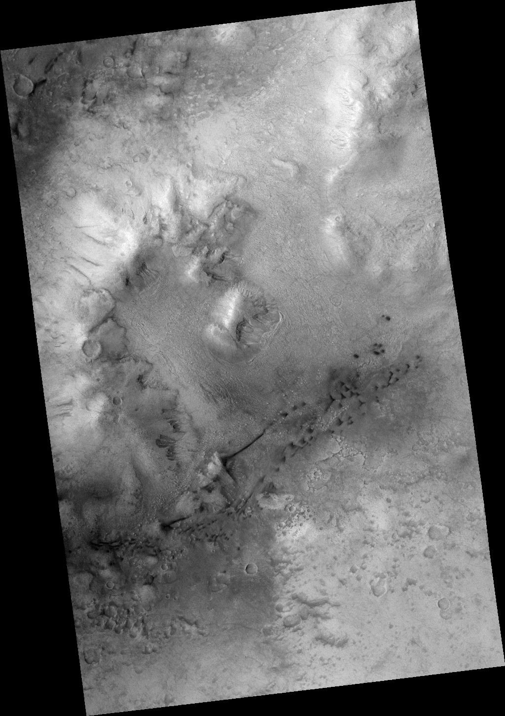
Click for full image.
The wide angle image to the right, taken by the context camera on MRO and cropped, reduced and annotated by me, shows the area covered by both of these 2009 and 2020 MRO photos. The smaller white box shows the area of the 2020 image that I have highlighted above. The region covered is most of the crater’s central peak mountains, with the central peak the rounded mound near the center.
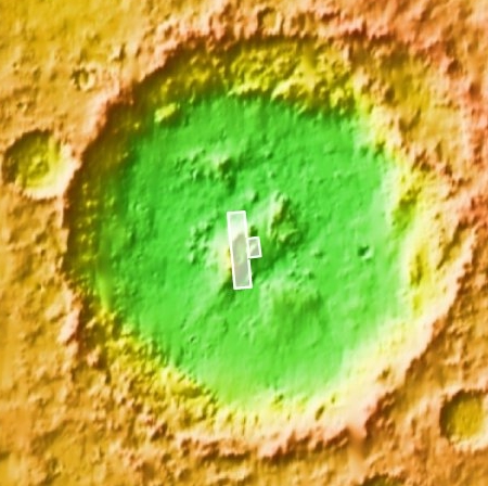
The map below shows all of Lohse Crater, with the two white rectangles indicating the area of the central peak covered by these photos.
The highlighted words in the quote above help explain much. The latitude of this crater, about 43 degrees south, puts it squarely in those mid-latitude bands, which in the decade since 2009 scientists have concluded contain numerous glacial features.
Thus, it would not be surprising if this crater contains glacial material, and that sublimating ice or some form of melting water brine is a cause of this gully erosion. Some high resolution images, such as this 2009 photo of the crater floor, suggest eroding glacial debris. So does some of the lower elevation features in the first two images above.
However, this 2018 image of a different part of Lohse Crater’s floor does not resemble the typical glacial features usually seen in mid-latitude craters, though it does show a very eroded surface that might be from sublimating underground ice.
The gullies here remain a significant Martian scientific mystery. They suggest the presence of flowing liquid water, but such flowing water cannot exist in the present climate and thin atmosphere of Mars. Nor have any scientists been able to develop a generally accepted model that makes possible the right kind of climate for flowing water, at anytime in the far past.
The hypothesized presence of glacial material might help explain what we see, though it would be a mistake to assume the explanation is that simple. There is more going on here than I think we presently know. Better data is needed, most likely gathered in situ on Mars itself.

On Christmas Eve 1968 three Americans became the first humans to visit another world. What they did to celebrate was unexpected and profound, and will be remembered throughout all human history. Genesis: the Story of Apollo 8, Robert Zimmerman's classic history of humanity's first journey to another world, tells that story, and it is now available as both an ebook and an audiobook, both with a foreword by Valerie Anders and a new introduction by Robert Zimmerman.
The print edition can be purchased at Amazon or from any other book seller. If you want an autographed copy the price is $60 for the hardback and $45 for the paperback, plus $8 shipping for each. Go here for purchasing details. The ebook is available everywhere for $5.99 (before discount) at amazon, or direct from my ebook publisher, ebookit. If you buy it from ebookit you don't support the big tech companies and the author gets a bigger cut much sooner.
The audiobook is also available at all these vendors, and is also free with a 30-day trial membership to Audible.
"Not simply about one mission, [Genesis] is also the history of America's quest for the moon... Zimmerman has done a masterful job of tying disparate events together into a solid account of one of America's greatest human triumphs."--San Antonio Express-News
I don’t have much business I know commenting in this company of learned minds on fascinating stories like this (I love studying all these other-world photos)… I am very familiar, since a toddler, myself growing up a human water dog on the coast, I come from a family of seafaring and underwater diving professionals; I spent many hours enjoying my Central Coastal freshwater riparian places as well …… so it struck me very strongly after studying this photo days ago … and I finally decided to post this observation:
… the right hand side, top to bottom, of the photo has the unique look of what sand does underwater only. Those distinct ripples are NOT duplicated in windblown sand at any time that I have ever seen, (I was born and raised exploring and enjoying some of of the largest sand dunes on the West Coast).
For what it’s worth — on earth, I’d look at that sand and know, “These ripples were formed while this sand was underwater.”
janyuary: You might be right, but you have to always remind yourself when looking at images of the surface of Mars that the gravity is one-third that of Earth’s. The formation of ripples is going to be fundamentally changed by that fact.
There has been a lot of research done on sand ripples on Mars. If you do a search on BtB just for “ripples” you will get a hint. A lot of it deals with how these change, or not, as well as comparing the tiny ripples from the big ones. Some are moving, some are frozen in place.
Robert — thank you!
Here, I have always loved exploring even the most familiar dunes. They’re constantly shifting, especially the smaller ones. It is exasperating to see green-in-more-ways-than-one environmentalists get involved, trying to preserve and freeze in a status quo, a place where status quo is a cosmic joke!
I was also trying to get a grasp on how big those ripples actually are to my scale. I can see with my eyes on the coastline how nature works in what I perhaps incorrectly think of as fractals, nearly identical formations differing only in scale. It sure looks like evidence of water to me!! I wonder … what would it be like to swim in water that had one third the gravity you’d expect?