
The glaciers of Mars
For the future colonists of Mars, the question of finding water will not be that much of a problem. Not only have planetary geologists mapped out the existence of extensive water-ice in the Martian poles, they have found that the planet apparently has widespread glacier deposits in two mid-latitude belts from 30 to 60 degrees latitude.
The question will be whether those Martian settlers will be able to easily access this water. The data so far suggests that much of the Martian underground water at high latitudes is likely mixed with dust and debris. Extracting it might not be straightforward. There are hints that the ice table at latitudes about 55 degrees might be more pure, but could be somewhat deep below ground, requiring the settlers to become miners to obtain their water. Moreover, all these high latitude locations are in environments that are more hostile, and therefore more difficult to establish a colony.
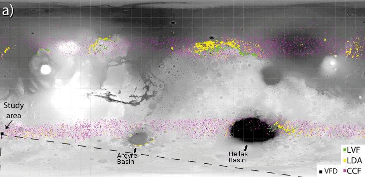
What about the glaciers? The global map of Mars above, reduced and annotated to post here, shows what are believed to be extensive glacial deposits at lower latitudes, and comes from a recently published paper on the subject. The different colors indicate the different types of glacial deposits the scientists have identified.
Green and yellow indicate what scientists call lineated valley fill (LVF) and lobate debris aprons (LDA) respectively, glacial deposits found in the transition zone between the southern highlands and either the northern lowland plains or the basins of the southern hemisphere, Hellas and Argyre. These glaciers are in many ways most similar to glaciers found on Earth, flows heading downhill along natural geographic features.
Magenta represents concentric crater fill (CCF), glacier features which seem very evenly distributed across both the northern and southern lower mid-latitude belts. Here scientists appear to have detected buried ice within the floors of craters.
The paper which included this map focused on describing a new glacial feature, something they dubbed valley fill deposits (VFD), that they had found so far in only one place, as indicated by the black square on the map.
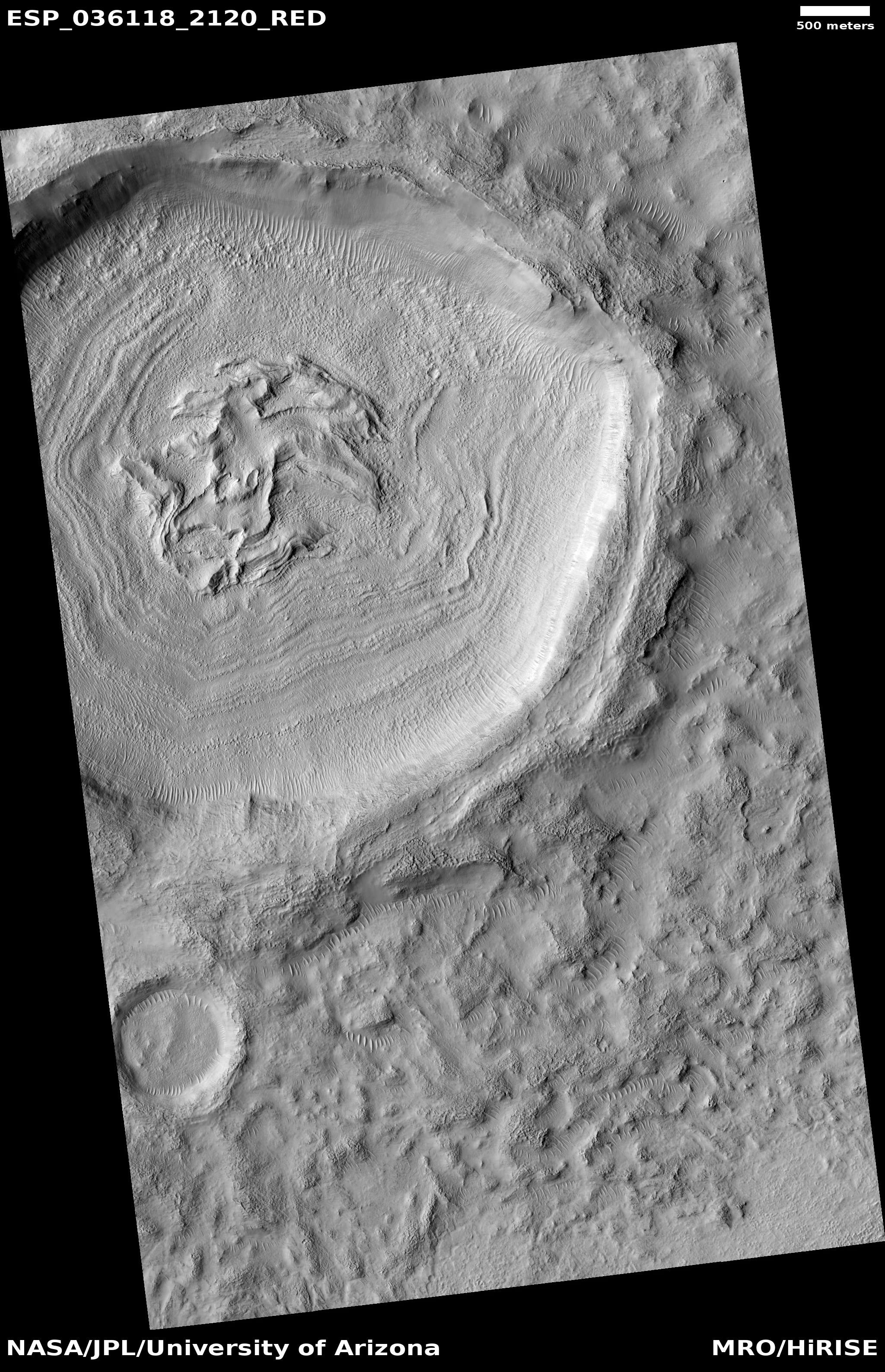
The photograph below and on the right, reduced and cropped to post here, is from figure two of the linked paper.

Click for full figure from the linked paper.
VFD refers to valley fill deposit, a buried glacier found within a valley system. From the caption:
VFD with longitudinal furrows. Note the marked circular feature which may represent a filled impact crater, and the adjacent small unmodified and fresh impact crater.
In the case of this newly found type of Martian glacier, the paper proposes that these glaciers formed as a result of the impact that formed the nearby 22-mile-wide Tarq crater about 410 million years ago. According to Solmaz Adeli of the German Aerospace Center (DLR), Institute of Planetary Research in Germany, and the lead author of the linked paper,
The impact happened into a surface covered by ice, or into a shallow subsurface ice layer. The impact event caused ice particles and surface solid material to be distributed over the surrounding area, including a valley system. Most of this icy-mixture has been sublimated away, but the deposit which fell into the valley has been protected by the valley walls. In addition, the morphology of the valley allows the deposition of a lag of dust and debris on top of the ice deposits, which then preserved the deposit from sublimation.
From the perspective of geologists, these different glacier types all have important distinctions that affect their formation and existence. To the ordinary future settlers of Mars, however, these differences are less important. What does matter is that they all suggest the presence of buried water-ice in many locations throughout the lower mid-latitudes of Mars.
Of course, there remains some uncertainty whether these features indicate the presence of buried glaciers. Sand and debris hides the ice from direct view.
The planetary researchers are fairly confident, however, that these features are glacial, based on data obtained from a variety of instruments and techniques. First, their visual shape, as photographed by several different orbiters, is reminiscent of the slow downward flowing glacier. Second, altimeter data shows that these features often have convex shapes as well as fractures and crevices both perpendicular and parallel to the flow direction, also reminiscent of glaciers. Finally, radar data from one instrument on Mars Reconnaissance Orbiter (MRO), designed to look for ice below the surface, confirms the presence of buried ice at those locations where it has looked.
The genesis and decay of these glaciers is directly related to the large climatic changes that scientists believe Mars has undergone over the eons.
While the rotational tilt of both the Earth and Mars are presently about the same, 23 and 25 degrees respectively, Mars’s tilt changes far more than the Earth’s. Over time that tilt, also called obliquity, can range from 10 to 60 degrees, with the tilt being more than 25 for most of the planet’s history. Some planetary geologists theorize that when the tilt was greater than 30 degrees the planet’s icecaps begin to melt, with much of that water being distributed to the mid-latitudes. From the linked paper:
Over the past 20 [million years], Mars’ obliquity variations caused significant changes in the Martian seasonal cycles. Head et al. (2003) hypothesize an ice age between 2.1 and 0.4 [million years] ago, when the obliquity exceeded 30° and water ice was removed from the polar regions and transported to midlatitudes, where a thin mantle of ice‐dust covered the surface. The end of this ice age is recorded by the rapid accumulation of north polar layered deposits resulting from the retreat of ice from the mid-latitudes
Another research paper put it this way:
Mars is at present in an ‘interglacial’ period, and the ice-rich deposits are undergoing reworking, degradation and retreat in response to the current instability of near-surface ice. Unlike the Earth, martian ice ages are characterized by warmer polar climates and enhanced equator-ward transport of atmospheric water and dust to produce widespread smooth deposits down to mid-latitudes.
There are many uncertainties about this theory. For example, why have glacial features only been found along these mid-latitude belts? This Martian ice-age model, based on the changes in Mars’ rotational tilt, does not explain the specificity of the mid-latitude belts. Why are the edges of these belts so sharp? Wouldn’t you expect the presence of glaciers to slowly tail off as you move north and south? We don’t however. Some unknown aspect of the Martian climate and obliquity over time has left these glaciers in these specific belts, even as they are presently slowly sublimating away.
Nonetheless, the theory suggests that Mars has undergone many past ice-age cycles as its rotational tilt shifted back and forth, much as the Earth has experienced past ice ages due to changes in its own rotational tilt. Unlike Earth, changes in the Martian obliquity were much more drastic. And with each of these cycles, the theory says the planet’s water-ice was redistributed across Mars from pole to mid-latitudes and back again.
At present, according to this theory, Mars is presently between ice ages, with the ice in the mid-latitudes decaying and returning to the poles.
Click for full image.
For future explorers, the problem will be this: How to get at this buried ice? Based on the accumulated research, the glaciers inside craters, dubbed concentric crater fill, are found most widely within these belts. Moreover, according to Adeli, “I would choose concentric crater fill [glaciers] because they are deposited in craters which makes is easier to estimate the depth of the deposited material.” Adeli also notes that craters tend to be traps for windblown dust, which in turn can act to protect the glacial ice, since the ice can only sublimate away from the top, and that top is well covered with that windblown dust.
To the right is one example of this type of crater glacial fill, located at about 32 degrees north latitude, taken by the high resolution camera of Mars Reconnaissance Orbiter (MRO) in April 2014. I have rotated, cropped, and reduced the image to post here.
Thus, future Martian colonies might not be built in caves, but along the inside walls of these mid-latitude craters, where it will not only be relatively easy to build a base, but have water ice accessible nearby.

On Christmas Eve 1968 three Americans became the first humans to visit another world. What they did to celebrate was unexpected and profound, and will be remembered throughout all human history. Genesis: the Story of Apollo 8, Robert Zimmerman's classic history of humanity's first journey to another world, tells that story, and it is now available as both an ebook and an audiobook, both with a foreword by Valerie Anders and a new introduction by Robert Zimmerman.
The print edition can be purchased at Amazon or from any other book seller. If you want an autographed copy the price is $60 for the hardback and $45 for the paperback, plus $8 shipping for each. Go here for purchasing details. The ebook is available everywhere for $5.99 (before discount) at amazon, or direct from my ebook publisher, ebookit. If you buy it from ebookit you don't support the big tech companies and the author gets a bigger cut much sooner.
The audiobook is also available at all these vendors, and is also free with a 30-day trial membership to Audible.
"Not simply about one mission, [Genesis] is also the history of America's quest for the moon... Zimmerman has done a masterful job of tying disparate events together into a solid account of one of America's greatest human triumphs."--San Antonio Express-News
As just a wild stab at why the mid-latitude glaciers might form a distinct line, what if frozen CO2 somehow inhibited the formation or survival of glaciers at higher latitudes during these periods of intense glaciation? Could the remaining line mark the border of an older CO2 cap?
I have no idea what that might entail, because this is just a stab off the top of my head, but dry ice is far denser than water ice (so it would like to be underneath) but is going to freeze out of the atmosphere much later, and therefore should be on top. CO2 sublimates much more easily than water ice, and perhaps that helped drive off or transport thick accumulations of surface dust, leaving the water ice exposed, but only in the higher-latitude regions where there were large and retreating dry ice deposits.
I’d have to think some more about how CO2 layers might effect what happens in a crater, or I need a box full of sand, some water, some CO2, and a really good freezer to see what happens.
What if the higher latitude craters didn’t get covered in much dust because most all the available dust sources at those latitudes were covered with dry ice during most of the period? If the onset of the subsequent interglacial was rapid, there may not have been much time for the accumulation of dust between the retreat of the dry ice ground cover and the complete sublimation of the underlying water ice in the glaciers. That would have to contrast with the lower-latitude glaciers that weren’t covered in CO2, and which got buried under lots of blowing dust. That could perhaps happen if dust transport was largely local and didn’t easily cross lines of latitude. That doesn’t seem to hold true today, but maybe it was true back then when more of the atmosphere had probably frozen out.
And that’s the extent of my wild guesses. Perhaps we should send some geologists there to analyze dust thickness and see if there’s any way they can date some layers.
I wrote a brief paper (that was one of those delivered at the founding meeting of The Mars Society if anyone is interested in looking it up) about how future colonists could use current oilfield management techniques to manage Martian waterfields.
Basically it says that with multilateral drilling you could in theory drill into ice-bound regolith and deeper on into hotter layers to establish a waterflow. A managed flow of water could then be used to melt out the ice at any depth. The heat necessary coming from the deeper wells. The trick would be to find water deposits that overlie a thermal intrusion into shallower regolith. It would be super to know more about what the graph of temp vs depth looks like and how we might find a shallow hot zone (analogous to a terrestrial magma chamber or Yellowstone equivalent).
Also worth noting that some potentially large liquid water deposits at higher altitudes maybe be trapped under a frozen layer. Melting these traps out could cause massive outburst flooding (see Terraforming by Martyn Fogg).
There have been significant advances from Mars Express since this article was written, notably documentation of major ice deposits in the Mars’s equatorial area in the south of Amazonis Planitia, particularly Medusae Fossae Formation. This should significantly broaden the options for human landing sites.
Scientific publication: https://doi.org/10.1029/2023GL105490
Science news article: https://www.space.com/mars-water-ice-equator-frozen-ocean