
Strange pitted and isolated ridges on Mars
Click for full image.
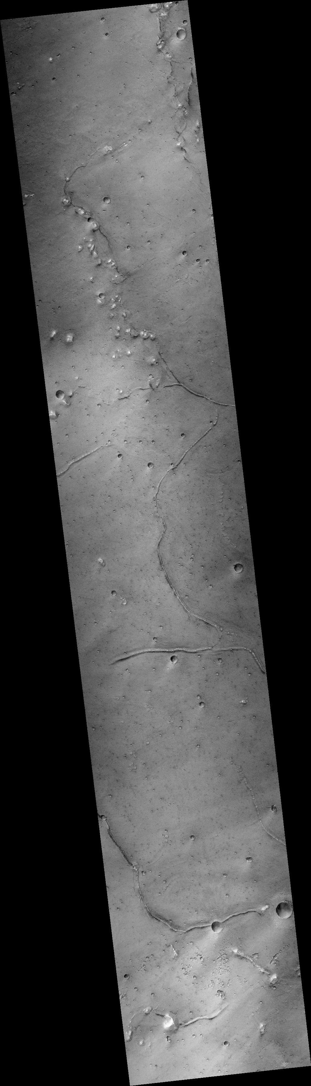
Cool image time! The photo to the right, rotated, cropped, and reduced to post here, was taken on February 17, 2012 by the wide-view context camera on Mars Reconnaissance Orbiter (MRO). It shows a section of the northern lowland plains of Mars, latitude 31 degrees north, where several very inexplicable and isolated ridges can be seen.
One ridge meanders mostly in a north-south direction, while a second instead meanders east-west. The shape of both says that neither has anything to do with any past impact crater. In fact, their random snakelike shape doesn’t really fit any obvious explanation. For example, they do not fit the look of the many fossil rivers found on Mars, where the hardened and dry riverbed channel resists erosion and becomes a ridge when the surrounding terrain erodes away.
What geological process caused them? In the decade since this photo was taken the scientists who use MRO have only been able to snap a handful of high resolution images of these ridges. The image below is the most recent, covering the area in the white rectangle above.
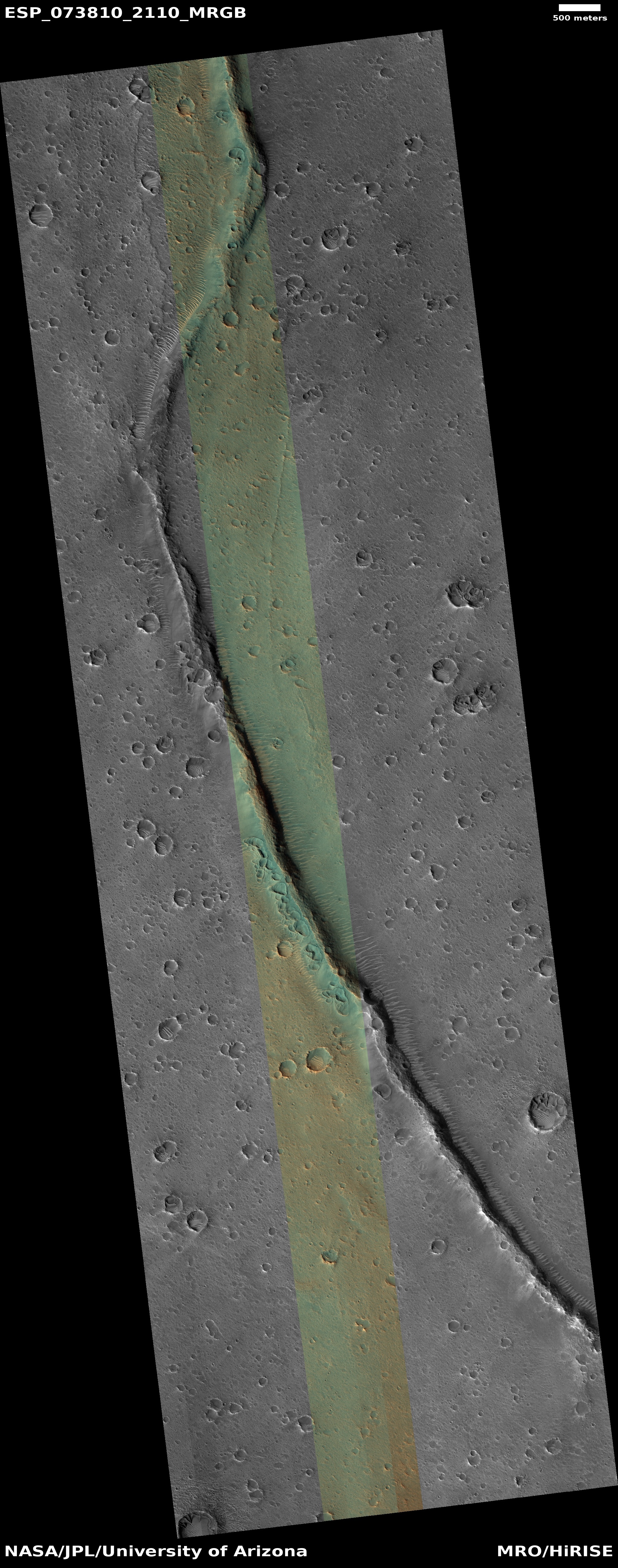
Click for full image.
The photo to the right, taken on April 25, 2022, has been rotated, cropped, and reduced to post here. It shows that this strange isolated ridge is not only strong enough to resist erosion, it also has a strange string of misshapen pits along its western flank. If you look at the full image you will see that these pits are mostly found in the cropped section to the right, that for most of the ridge’s length there are far fewer pits and craters, and never in the concentration seen here.
To my eye, these pits remind me of the kind of pits caused by drops of water falling on sand at a beach. That impression suggests impacts in Martian dunes, but the location along this ridge says no. The odds of a bunch of meteorites hitting the ground so perfectly aligned with the ridge is practically nil. More likely these pits were formed by some process relating to the existence of the ridge itself.
For what it is worth, the different colors suggest that the greenish material near the ridge is made of a coarser sand or debris than the yellowish material to the west.
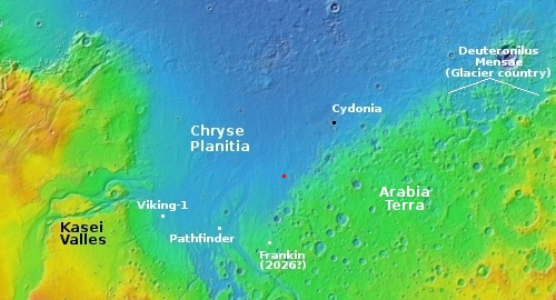
The overview map to the right marks the location with the red dot, about 900 miles to the southwest of the region Cydonia and the non-face on Mars (indicated by the black dot). Since Cydonia is filled with many strangely shaped mesas, it is thus not surprising that the full image from the context camera above also includes a scattering of mesas, many of which are aligned along the ridge.
That alignment provides us another possible explanation for this ridge and its misshapen pits. Maybe it was formed by some type of volcanic activity, either from magma or water ice, pushing up the ridge with the pits a variation of small calderas.

On Christmas Eve 1968 three Americans became the first humans to visit another world. What they did to celebrate was unexpected and profound, and will be remembered throughout all human history. Genesis: the Story of Apollo 8, Robert Zimmerman's classic history of humanity's first journey to another world, tells that story, and it is now available as both an ebook and an audiobook, both with a foreword by Valerie Anders and a new introduction by Robert Zimmerman.
The print edition can be purchased at Amazon or from any other book seller. If you want an autographed copy the price is $60 for the hardback and $45 for the paperback, plus $8 shipping for each. Go here for purchasing details. The ebook is available everywhere for $5.99 (before discount) at amazon, or direct from my ebook publisher, ebookit. If you buy it from ebookit you don't support the big tech companies and the author gets a bigger cut much sooner.
The audiobook is also available at all these vendors, and is also free with a 30-day trial membership to Audible.
"Not simply about one mission, [Genesis] is also the history of America's quest for the moon... Zimmerman has done a masterful job of tying disparate events together into a solid account of one of America's greatest human triumphs."--San Antonio Express-News
“Cool (puzzle) time”. Love them Mr. Z. Thanks !
The initial white box area image seems to have been pushed from the western surface area, as in a ( plate tectonic, mud flow direction) up to the ridge.
Coarser ‘sand’ (prior impact ?) stuff being more readily deformed than fine sand stuff. As a beach comber anyway.
Note how above and below the box area the western surface appears as flanking pincer movements. deforming the ridge flow direction. At least to my eyes in the black and white relief.
Next, reference the Pathfinder location, and its surrounding (surface) area which appears to flow / move out and to the east towards the ridge area under observation.
I think that the ridge area coarse sand stuff with its previous impact pits just got mushed up against the ridge due to a westerly flow from the Pathfinder delta region.
BTW, what are the horizontal (forgive me, stretch mark) areas in the images ?
Alex Andrite: The “horizontal stretch marks” are more ridges. I note them in the wider context camera image at the top of the post. These ridges orient in many random directions, which is one reason they are puzzling.
The distance from the flow patterns near the Pathfinder landing spot and these ridges — about 800 miles — makes any interaction unlikely, especially because these ridges are quite small in comparison. Moreover, the available data so far suggests those flow patterns were formed by catastrophic floods and intermittent seas several billion years ago. These ridges appear younger, and their appearance does not fit with those geological events.