
Terby Crater and its drainages into Mars’ basement

Click for full image.
Cool image time! Over the past few years, in my endless rummaging through the archive of high resolution images from Mars Reconnaissance Orbiter (MRO) I have posted a lot of photos of meandering channels of all kinds, most of which evoke to Earth eyes canyons eroded by flowing water. (This September 2020 cool image is just one of the more recent examples.)
Today’s cool image is another example, but in this case it is only a very small part of a very large drainage basin that is more than a hundred miles across and extends at least that far southward into the basement of Mars, Hellas Basin, the place on Mars with the lowest elevation.
The photo to the right, rotated and reduced to post here, was taken on September 12, 2020 by the high resolution camera on MRO. I normally wouldn’t post the whole image, but to crop it would mean you wouldn’t get the sense of extensive nature of this drainage. Downhill is to the south. The channel apparently passes through three or four stages. First, its northernmost section is in a wide canyon, the floor of which resembles glacial debris (though with a latitude of 27 degrees south this is a bit too close to the equator for ice). More likely we are looking at wind-blown sand and dunes being pulled downhill in the floor of the canyon.
This first canyon is also actually a gap in the rim of a 13-mile-wide unnamed crater. See this MRO context camera image for a wider view.
Next, the drainage becomes a series of meandering small interweaving channels, resembling the channels often seen in beach mud as the tide goes out.
Finally, the channels head into a gap to fall over a sloping cliff into lower terrain.
Nor these stages entirely linked. The first glacial-like stage exiting the gap in the crater appears to drain to the southeast, while the second seems to emanate from what appears to be a very faint small crater now partly buried. Both head south toward the gap, but the path of the eastward drainage appears less obvious. Some of it flowed westward to join the meandering channels but some also appears to work its way south more to the east.
This one image shows a lot of channels, but it is only a very small slice of this whole drainage system. In fact, we are looking here at only one strip of the interior slope of the northern rim of 108-mile-wide Terby Crater.
The overview map below gives the larger context. Terby Crater sits on the northern border of Hellas Basin, which in itself extends another 1,500 miles to the south. From this point the drop in elevation into Hellas is almost four miles.
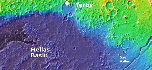
Hellas Basin itself is thought to have been formed by a very large impact about four billion years ago. Since then there is evidence that it was once filled with a giant lake that slowly evaporated away, with Terby Crater sitting on the edge of the largest and oldest hypothesized body of water.
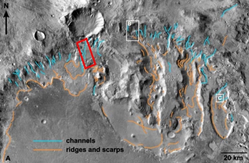
Inside the northern half of Terby Crater are a series of large mesas, separated by canyons and surrounded to the south by a wide apron of material. The photo to the right is figure 4 from a 2006 paper [pdf] that attempted to summarize what is known about this drainage region, and the processes that formed it over eons. The figure focuses on these mesas and canyons, and also documents the location of smaller channels within these canyons. The red box, added by me, indicates the location of today’s cool image. As the authors write in their abstract:
Once the lake in Hellas decreased, the layers in Terby were incised by troughs and a moat-like depression. We attribute this erosion to scour beneath an ice cover due to a lack of integrated fluvial drainage or large aeolian deflation features. The presence of viscous flow features in a crater on Terby’s northwestern rim and lobate features on Terby’s crater floor are also indicative of ice. The lack of depositional features associated with the postulated glacial activity suggests there was a contemporaneous shallow (ice-covered?) lake covering the floor of Terby that transported material into the greater Hellas basin.
In other words, they think that the erosion in these canyons, as well as the channels in the first image above, occurred underneath ice, either by the slow downward movement the ice itself or by melted water trapped at the base of that ice. The key phrase in their abstract is “a lack of integrated fluvial drainage”, which describes exactly what I noted above about this particular image. The drainages are not strongly linked.
The mesas themselves, which appear to be formed by several layers of distinctly different materials, are thought to have been formed in connection with the icy lakes that once sat within Terby, and Hellas. The canyons, or troughs between these mesas formed as those lakes and their ice drained away. From the paper:
We suggest that the flow and possible melting of thick ice deposits could have formed the large troughs in Terby. The involvement of ice by glacial scour or dissolution is consistent given the scale and geomorphology of the features and the evidence for the past and present involvement of glaciers on Mars.
As always, there are uncertainties. The canyons lack certain features you’d expect to see if this hypothesis was correct, such as “moraines, cirques, and outwash plains.” Additionally, the data itself is still superficial, obtained from orbit by only a handful of instruments. Closer inspection, on the ground, is required to get a more firm understanding.

On Christmas Eve 1968 three Americans became the first humans to visit another world. What they did to celebrate was unexpected and profound, and will be remembered throughout all human history. Genesis: the Story of Apollo 8, Robert Zimmerman's classic history of humanity's first journey to another world, tells that story, and it is now available as both an ebook and an audiobook, both with a foreword by Valerie Anders and a new introduction by Robert Zimmerman.
The print edition can be purchased at Amazon or from any other book seller. If you want an autographed copy the price is $60 for the hardback and $45 for the paperback, plus $8 shipping for each. Go here for purchasing details. The ebook is available everywhere for $5.99 (before discount) at amazon, or direct from my ebook publisher, ebookit. If you buy it from ebookit you don't support the big tech companies and the author gets a bigger cut much sooner.
The audiobook is also available at all these vendors, and is also free with a 30-day trial membership to Audible.
"Not simply about one mission, [Genesis] is also the history of America's quest for the moon... Zimmerman has done a masterful job of tying disparate events together into a solid account of one of America's greatest human triumphs."--San Antonio Express-News