
Volcanic badlands on Mars
Click for full image.
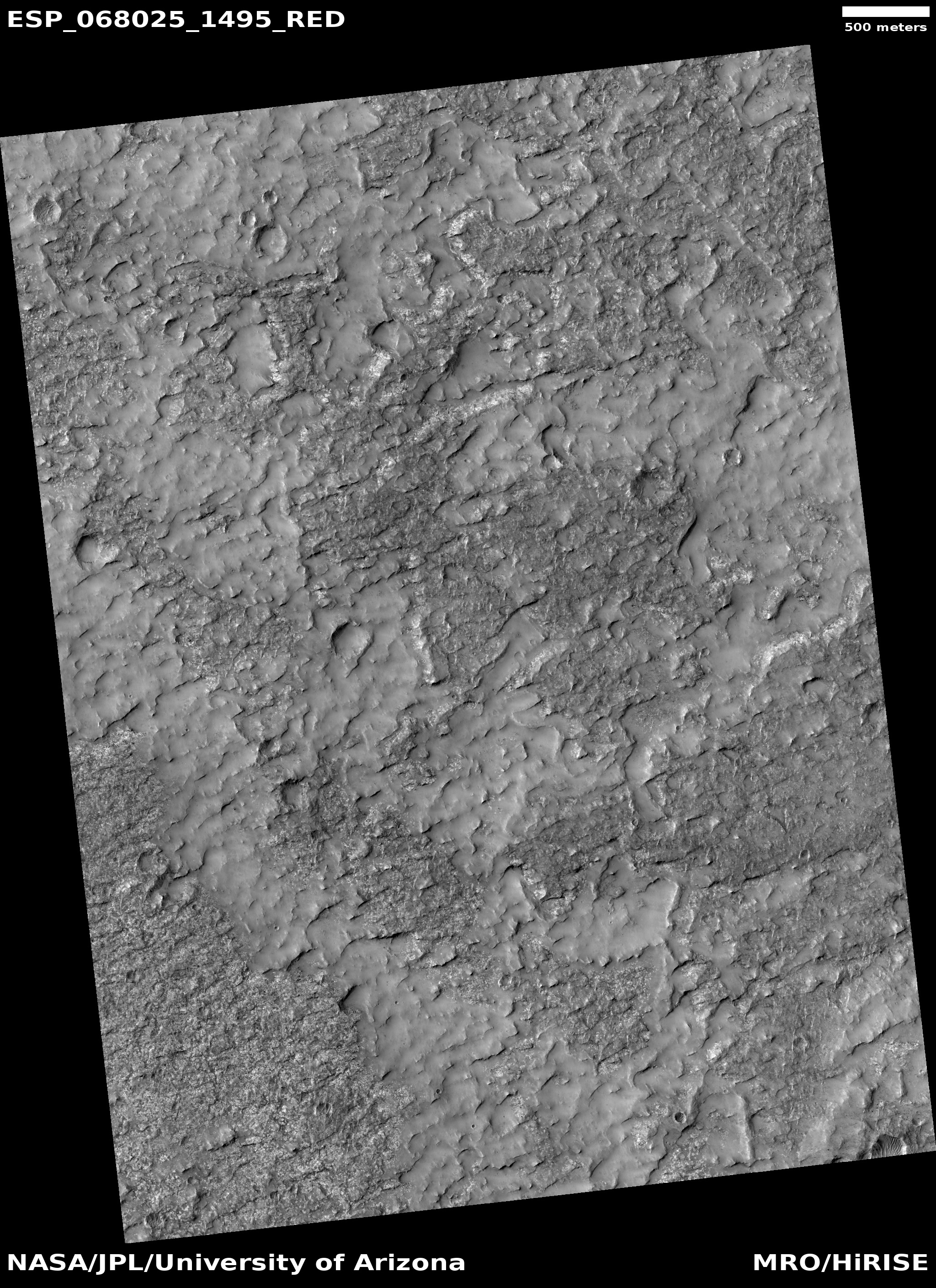
Cool image time! The photo to the right, cropped and reduced to post here, was taken on January 29, 2021 by the high resolution camera on Mars Reconnaissance Orbiter (MRO). It shows a particularly ugly region of rough terrain located about 900 miles to the southwest of the giant volcano Arsia Mons, the southernmost of the chain of three giant volcanoes between Olympus Mons and Valles Marineris. The picture sits inside the floor of a very old and degraded 185-mile-wide crater dubbed Koval’sky.
The section I cropped out was picked at random, because the entire full image looked like this. Though only a handful of images have been taken of the floor of Koval’sky Crater by MRO’s high resolution camera, all show similar rough terrain. In June 2017 the MRO science team posted one of those few such photos with the following caption:
This image shows partially exposed bedrock within the Koval’sky impact basin, which is on the outskirts of the extensive lava field of Daedalia Planum. Daedalia Planum is located southwest of Arsia Mons, which may be the source responsible for filling the crater with lava flows and ash deposits.
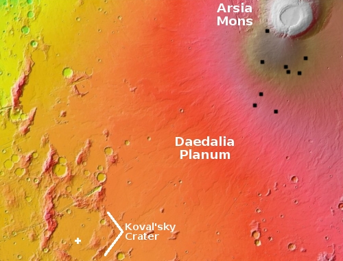
The overview map to the right gives the context. The white cross is where this cool image was taken. The black dots are locations where pits have been found.
The vast flows from Arsia Mons appear to have reached out almost a thousand miles to this 4-plus billion year old crater to flood its interior. Being so old, that volcanic plain inside this crater has since become very badly eroded, producing the rough badland terrain we see here.
Note also that though this is at 30 degrees south latitude, there is no evidence of any glacial or ice features. This appears to be an arid and dry place, similar in fact to the equatorial badlands I have previously highlighted several times on the other side of Mars in a region dubbed Tyrrhena Terra (see here, here, and here.) In fact, it is remarkable how much the first two examples in Tyrrhena resemble this picture in Koval’sky Crater.
The image was also another terrain sample, taken not to follow-up on any particular research but to fill a gap in MRO’s schedule in order to maintain the camera’s temperature. Because so few high resolution images have been taken inside this crater the science team probably decided to snap another to also help fill that topological gap.

On Christmas Eve 1968 three Americans became the first humans to visit another world. What they did to celebrate was unexpected and profound, and will be remembered throughout all human history. Genesis: the Story of Apollo 8, Robert Zimmerman's classic history of humanity's first journey to another world, tells that story, and it is now available as both an ebook and an audiobook, both with a foreword by Valerie Anders and a new introduction by Robert Zimmerman.
The print edition can be purchased at Amazon or from any other book seller. If you want an autographed copy the price is $60 for the hardback and $45 for the paperback, plus $8 shipping for each. Go here for purchasing details. The ebook is available everywhere for $5.99 (before discount) at amazon, or direct from my ebook publisher, ebookit. If you buy it from ebookit you don't support the big tech companies and the author gets a bigger cut much sooner.
The audiobook is also available at all these vendors, and is also free with a 30-day trial membership to Audible.
"Not simply about one mission, [Genesis] is also the history of America's quest for the moon... Zimmerman has done a masterful job of tying disparate events together into a solid account of one of America's greatest human triumphs."--San Antonio Express-News
Is there a reason that MRO is seemingly haphazard at the pictures taken? I expected they would be methodically taking pictures of the entire surface and there wouldn’t be gaps in the schedule. Is it because it is intended for taking targeted pictures and not a project to have high resolution images of everything? Would that take too long?
Tim: MRO’s resolution is so high it will take many decades to cover the entire surface of Mars, so long that the spacecraft will likely fail beforehand. Thus, the pictures are taken focused on real areas of interest and research.
If you wish to see the entire planet covered, you need to look at the pictures taken by MRO’s context camera, which has a much lower resolution but covers a much wider area. In fact, that camera has already photographed the the entire planet.
If you wish to see the entire planet covered, you need to look at the pictures taken by MRO’s context camera, which has a much lower resolution but covers a much wider area. In fact, that camera has already photographed the the entire planet.
Tim: In addition to what Robert wrote above, NASA launched the Mars Global Surveyor a few years before MRO to create a global topographic map of Mars. They were meant to work as a pair, with MGS mapping the entire planet at medium resolution and finding interesting sites for MRO to photograph at high resolution.
In between NASA launched the Mars Odyssey whose main instrument, a neutron spectrometer, created a global hydrogen map of Mars (hydrogen being an element in many volatile components such as water, ammonia, and methane).
So it looks like even Mars has its Badlands its the only place Marvin and K-9 never go