
Has a NASA scientist discovered alien fossils in several meteorites?
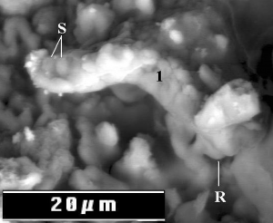
Very very intriguing: A NASA scientist has claimed in a peer reviewed paper the discovery of alien fossils in several meteorites recovered on Earth. From the paper’s last paragraph:
The absence of nitrogen in the cyanobacterial filaments detected in the CI1 carbonaceous meteorites indicates that the filaments represent the remains of extraterrestrial life forms that grew on the parent bodies of the meteorites when liquid water was present, long before the meteorites entered the Earth’s atmosphere.
The news article describing this discovery is a bit more breathless in style than I would like, and makes me suspicious about these results. Moreover, that NASA held no press release or press conference for a result of this significance gives me pause. (Though NASA might have felt burned from the reactions they got from the arsenic-based-biology press conference and decided therefore to take a low profile here.)
» Read more


