
May 1, 2026 Zimmerman/Batchelor podcast
Embedded below the fold in two parts.
To listen to all of John Batchelor’s podcasts, go here.
» Read more
Embedded below the fold in two parts.
To listen to all of John Batchelor’s podcasts, go here.
» Read more
An evening pause: The builder is a guy from Arizona, Bob DeFord.
Hat tip Cotour.

On Christmas Eve 1968 three Americans became the first humans to visit another world. What they did to celebrate was unexpected and profound, and will be remembered throughout all human history. Genesis: the Story of Apollo 8, Robert Zimmerman's classic history of humanity's first journey to another world, tells that story, and it is now available as both an ebook and an audiobook, both with a foreword by Valerie Anders and a new introduction by Robert Zimmerman.
The print edition can be purchased at Amazon or any other book seller. If you want an autographed copy the price is $60 for the hardback and $45 for the paperback, plus $8 shipping for each. Go here for purchasing details. The ebook is available everywhere for $5.99 (before discount) at amazon, or direct from my ebook publisher, ebookit. If you buy it from ebookit you don't support the big tech companies and the author gets a bigger cut much sooner.
"Not simply about one mission, [Genesis] is also the history of America's quest for the moon... Zimmerman has done a masterful job of tying disparate events together into a solid account of one of America's greatest human triumphs."--San Antonio Express-News
The $2 bill that astronaut Gene Cernan carried on all three of his space missions in 60s and 70s has now sold at auction for $91,519.
Signed and flight-certified by Cernan, the bill is encapsulated and graded by Paper Money Guaranty (PMG) as Choice Fine 15. The holder notes its provenance as having been flown aboard Gemini 9A (1966), Apollo 10 (1969), and Apollo 17 (1972), and traces its origin to Cernan’s personal collection.
A signed letter of provenance from Cernan states that the bill was originally owned by his father and later carried by the astronaut on each of his spaceflights. The letter documents its presence during low Earth orbit on Gemini 9A, lunar orbit on Apollo 10, and on the lunar surface during Apollo 17.
This auction was space-focused and realized a total of $1,764,603. It included items from a number of other Gemini and Apollo missions, including an American flag that astronaut Dave Scott flew on Gemini 8, the mission that achieved the first docking in space but then had to due an emergency splashdown because a thruster began firing uncontrollably. It sold for $47,406.
Hat tip reader Wayne DeVette.
Though in February 2026 NASA officials suggested there might be a Starliner cargo mission to ISS sometime in April 2026, the new schedule released today for ISS manned and cargo missions for the rest of this year shows no Starliner missions at all.
The press release hinted an extra Starliner mission could be added, but don’t but too much faith in this:
Launch opportunities for NASA’s uncrewed Boeing Starliner-1 cargo mission remain under review as teams continue working through technical issues discovered during the Crew Flight Test in 2024, as well as final actions from the Program Investigation Team report. The agency is assessing operational readiness and space station traffic to determine the earliest feasible launch window.
What I think is happening in NASA is that the agency under Isaacman wants a better assurance from Boeing that the problems with Starliner have been fixed, and Boeing is having trouble satisfying them. If so, it seems he is doing what I suggested in February, demand from Boeing the highest quality work or don’t buy anything from it at all. If so kudos to Isaacman.
It is also possible Isaacman doesn’t want to spend extra money paying Boeing for this extra cargo mission to prove out Starliner’s systems. Boeing’s contract for Starliner is fixed price, and the capsule’s multiple problems has now cost the company more than a billion dollars. It is unlikely it will have make a profit on it, which is why it wants NASA to pay for that cargo flight.
Either way, the first operational manned mission using Starliner continues to recede into the future, to the point where ISS might be gone before the capsule is finally okayed for manned flights.

Now available in hardback and paperback as well as ebook!
From the press release: In this ground-breaking new history of early America, historian Robert Zimmerman not only exposes the lie behind The New York Times 1619 Project that falsely claims slavery is central to the history of the United States, he also provides profound lessons about the nature of human societies, lessons important for Americans today as well as for all future settlers on Mars and elsewhere in space.
“Zimmerman’s ground-breaking history provides every future generation the basic framework for establishing new societies on other worlds. We would be wise to heed what he says.” —Robert Zubrin, founder of the Mars Society.
All editions are available at Amazon, Barnes & Noble, and all book vendors, with the ebook priced at $5.99 before discount. All editions can also be purchased direct from the ebook publisher, ebookit, in which case you don't support the big tech companies and the author gets a bigger cut much sooner.
Autographed printed copies are also available at discount directly from the author (hardback $29.95; paperback $14.95; Shipping cost for either: $6.00). Just send an email to zimmerman @ nasw dot org.
Courtesy of BtB’s stringer Jay. This post is also an open thread. I welcome my readers to post any comments or additional links relating to any space issues, even if unrelated to the links below.
SpaceX today successfully placed another 29 Starlink satellites into orbit, its Falcon 9 rocket lifting off from Cape Canaveral Space Force Station in Florida.
The first stage (B1069) completed its 31st flight, landing on a drone ship in the Atlantic, 63 days after its previous flight. It remains in 6th place in the rankings of the most reused launch vehicles:
39 Discovery space shuttle
34 Falcon 9 booster B1067
33 Atlantis space shuttle
32 Falcon 9 booster B1071
32 Falcon 9 booster B1063
31 Falcon 9 booster B1069
28 Columbia space shuttle
27 Falcon 9 booster B1077
27 Falcon 9 booster B1078
The leaders in the 2026 launch race:
53 SpaceX
23 China
8 Russia
6 Rocket Lab
For the third straight year SpaceX continues to lead the entire world combined in total launches, 53 to 44.

Leaving Earth: Space Stations, Rival Superpowers, and the Quest for Interplanetary Travel, can be purchased as an ebook everywhere for only $3.99 (before discount) at amazon, Barnes & Noble, all ebook vendors, or direct from my ebook publisher, ebookit.
If you buy it from ebookit you don't support the big oppressive tech companies and I get a bigger cut much sooner.
"Leaving Earth is one of the best and certainly the most comprehensive summary of our drive into space that I have ever read. It will be invaluable to future scholars because it will tell them how the next chapter of human history opened." -- Arthur C. Clarke
It appears that NASA has already recognized that the next Artemis mission, dubbed Artemis-3 and changed from a lunar landing to an Earth orbit test flight, will not happen on the schedule as first proposed by NASA administrator Jared Isaacman.
During the hearing on Monday, Congressman Hal Rogers (R-Ky.), chairman emeritus of the committee, asked Isaacman about his confidence that Artemis 3 would remain on schedule, given the amount of money allocated for the mission’s landers.
“I’ve received responses from both vendors [SpaceX and Blue Origin],” Isaacman said, “to meet our needs for a late 2027 rendezvous, docking and test [of] the interoperability of both landers in advance of a landing attempt in 2028.”
That’s a shift from Isaacman’s statements during his Feb. 27 Artemis strategy presentation, during which he said, “Artemis 3 will have its opportunity, if we can, by mid-2027, which sets us up for an early ’28 and a late ’28 opportunity [for Artemis 4 and 5].” [emphasis mine]
In other words, Artemis-3 has already shifted from mid-’27 to late-’27. Though Isaacman is pushing hard to speed up the launch cadence of the entire Artemis program, reality is once again proving stronger. We should fully expect Artemis-3 to shift into 2028, partly because the lunar landers — especially Blue Origin’s Blue Moon — might not be ready but mostly because SLS is simply too cumbersome a rocket to stack quickly. Isaacman wants to speed up its launch cadence to once a year. The best we should expect is 18 months to two years.
As for getting two manned lunar landings in 2028, Isaacman might want it but the odds are slim to none. If Artemis-3 flies in late ’27 it will be almost impossible to get SLS ready for a landing mission before the end of ’28.
In the end, these delays will illustrate the need to replace SLS with private commercial launchers.
The Federal Communications Commission (FCC) yesterday approved new spectrum rules proposed by SpaceX that will increase the capacity of all the new low-Earth-orbit constellations by as much as seven times.
The commission introduced the new rules earlier this month before approving them at a Thursday meeting. The revamp targets the Equivalent Power Flux Density (EPFD) rules, which were developed in the late 1990s and limited the amount of energy satellite systems could transmit to and from ground equipment. The regulations were also designed to prevent radio signal interference between higher-orbiting geostationary satellites and lower-orbiting systems. But during the vote, Carr said the decades-old existing rules were “holding back” newer satellite internet offerings.
“Modern satellite designs make it far easier to share spectrum than what yesterday’s regulations assumed. We can do a lot better,” he said. Carr touted the 7x increase when the commission found the revamped rules could enable “eight satellites to provide service simultaneously in a given geographic area and frequency band, instead of being effectively limited to one satellite under current EPFD limits.”
The FCC was sold on this change after SpaceX conducted its own tests in orbit, using Starlink satellites, to demonstrate it could work. The rule change will benefit all the new constellations, which is why Amazon’s Leo constellation supported the change as well.
The speed in which the FCC acted on this matter must also be noted. It did not bother with long studies of its own. It quickly reviews SpaceX’s work, realized it made sense, and scheduled the vote at its very next meeting. This constrasts starkly with the FCC during the Biden administration, which routinely slow-walked or even opposed such suggestions.
In what is no surprise if one watched last week’s House hearing about the NASA budget, the House Appropriations committee yesterday approved a NASA budget for fiscal year 2027, giving the agency the same funding it had in 2026, just over $24 billion, rejecting Trump’s proposed major reduction in the budget of over $5 billion.
The vote was along party lines, with the Republicans approving and the Democrats opposing. As expected, while the overall budget was maintained, the Republicans went along with the sense of Trump’s cuts — and the desires of NASA administrator Jared Isaacman — by shifting money from science to exploration within the budget.
The subcommittee bill provides $8.926 billion for human exploration, an increase of about $400 million above the request, and the request itself favors exploration. … The subcommittee’s bill raises the FY2027 level for [NASA science] to $6 billion, but that’s still a $1.3 billion reduction from current spending as Ranking Member Grace Meng (D-New York) pointed out.
The bill also agreed with Trump’s proposal to eliminate NASA’s STEM education office, something Isaacman had repeatedly testified was redundant and a waste of money.
In other words, the committee is giving Isaacman more flexibility with the money it is giving him, as I predicted.
This is only the first step in the budget process. The budget still has to be approved by the full House, the Senate, and the President. Expect changes.
According to Russia’s state-run press, it successfully completed the first suborbital test flight of its new Soyuz-5 rocket, the rocket lifting off from Baikonur in Kazahkstan on April 28, 2026 carrying a dummy payload.
A special launch was conducted today as Soyuz-5, a new Russian carrier rocket with the world’s most powerful liquid-fuel engine, blasted off. <...> Operating the rocket will make it possible to substantially reduce the unit cost of the payload capacity. This will have a positive impact on the economics of space launches,” the Russian state-owned space corporation quoted its CEO Dmitry Bakanov as saying.
The rocket will eventually be able to place about 17 tons in low Earth orbit, making it more powerful than the Soyuz-2 — now used to launch capsules and satellites — but less powerful than Russia’s Proton rocket, used to launch station modules and other more demanding missions.
Soyuz-5 however is not reusable, so it will remain more expensive to use that the new rockets being developed everywhere else outside Russia. Like all of Russia’s rockets, stages will continue to fall inside Russia with each launch. In this case, the first stage and fairings crashed somewhere in Russia, while the second stage splashed down in the Pacific.
According to a NASA press release late yesterday, Ireland will sign the Artemis Accords on May 4, 2026, becoming the 65th nation to join this American space alliance.
NASA Administrator Jared Isaacman will host Ambassador of Ireland to the United States of America Geraldine Byrne Nason; Minister for Enterprise, Tourism and Employment Peter Burke, T.D., of Ireland; and U.S. Department of State officials for the ceremony.
As I predicted yestesday when Morocco signed the accords, the success of the Artemis-2 mission around the Moon has prompted a number of smaller third world countries to finally sign the accords, and thus should expect more signings to follow. Ireland illustrates this. There will be more soon.
The full list of nations in this American space alliance is as follows:
Angola, Argentina, Armenia, Australia, Austria, Bahrain, Bangladesh, Belgium, Brazil, Bulgaria, Canada, Chile, Colombia, Cyprus, Czech Republic, Denmark, Dominican Republic, Ecuador, Estonia, Finland, France, Germany, Greece, Hungary, Iceland, India, Ireland, Israel, Italy, Japan, Jordan, Latvia, Liechtenstein, Lithuania, Luxembourg, Malaysia, Mexico, Morocco, the Netherlands, New Zealand, Nigeria, Norway, Oman, Panama, Peru, Poland, Portugal, Romania, Rwanda, Saudi Arabia, Senegal, Singapore, Slovakia, Slovenia, South Korea, Spain, Sweden, Switzerland, Thailand, the Philippines, the United Kingdom, the United Arab Emirates, the Ukraine, the United States and Uruguay.
An evening pause: Performed live 2011.
Hat tip Rex Ridenoure.
Courtesy of BtB’s stringer Jay. This post is also an open thread. I welcome my readers to post any comments or additional links relating to any space issues, even if unrelated to the links below.

India’s Bharatiya Antariksh Station as outlined in 2024.
Click for original image.
India’s space agency ISRO yesterday released its annual report [pdf], outlining its accomplishments over during 2025.
Like all such reports, it is filled with glowing superlatives. It provides little concrete information about the agency’s more serious issues, such as what it is doing to fix the upper stage of its PSLV rocket, which has failed on the last two consecutive launches. All the annual report says on this subject is the following:
Based on the recommendations of the National Level Committee comprising of eminent experts from academia & industry, the third stage of PSLV i.e., HPS3 motor with modified design was realised and two static tests were successfully completed on October 06, 2025 and November 19, 2025 as in flight, from SDSC, SHAR. The overall performance of the motor and subsystems were as expected and closer to nominal performance.
The problem is that these fixes and tests did not work. The second failure of the upper stage occurred in January 2026, less than two months later. The annual report should have noted this fact, but did not.
As for India’s planetary program, digging out the present schedule from the report is difficult. Based on this review of the annual report, the dates are as follows:
Expect these dates to be delayed.
The report also gives a detailed description on India’s Gaganyaan manned program, but little information about the planned unmanned tests that were planned for this year, leading to a manned orbital mission next year. At the moment the schedule appears to be experiencing delays, caused mostly by the PSLV launch failures. It appears ISRO wants this issue resolved before it launches that first unmanned Gaganyaan test flight.
If you want to get an overview of India’s government space program, this annual report is a good place to start. It will at least provide a baseline on which you can build a deeper knowledge.
Click for original image.
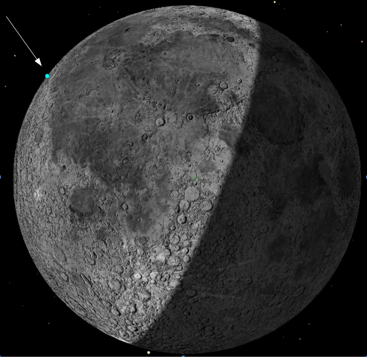
According to astronomer Bill Gray, who also tracks orbital objects, the upper stage of the Falcon 9 that launched Firefly’s Blue Ghost and Ispace’s Hakuto-R2 lunar landers in January 2025 will hit the Moon on August 5, 2026.
For some time, I’ve provided some software tools astronomers can use to identify satellites in their data. I use the US military’s publicly available satellite data for many objects, and compute orbits for high-orbiting objects the military doesn’t track.
This object falls squarely in the latter category. In September 2025, my software for computing orbits analyzed the observations and projected an impact with the moon on 2026 August 5.
While this looked like a pretty solid prediction, I couldn’t be totally sure of it at the time. The motion of space junk is mostly quite predictable; it simply moves under the influence of the gravity of the earth, moon, sun, and planets. We know those with immense precision. If those were the only factors involved, I could probably tell you where and when this object would hit the moon to within a few meters and a fraction of a second.
The problem is that space junk in general, and 2025-010D in particular [the upper stage], is also pushed around by sunlight (“solar radiation pressure”). This is an extremely gentle force, but over months, it can really build up. And it’s not entirely predictable. As an object tumbles, it may catch more or less sunlight, and may reflect some of it sideways. So sunlight is mostly pushing the object away from the sun, but there’s a slight bit of pushing in other directions as well.
With enough data, we can actually figure out where the forces are pushing an object. But they do change a little over time in ways that aren’t perfectly predictable. So I can be sure it will impact near the time and place I’ve predicted, but those varying forces mean that the actual impact will be at least a little off from that time and place. That’s the largest source of uncertainty in all this, and there’s no way to correct for it; we just have to wait and see what actually happens. (But come August, we’ll have a quite precise idea of where it will hit.
At present, Gray predicts the impact will occur at 2:44 am (Eastern) on August 5, 2026. The image above is his present estimate of where it will hit, as seen from Earth. If this prediction holds, the impact itself will likely not be visible from Earth, as it will occur in daylight and at the very western limb of the Moon. This prediction however could change somewhat in the next few months.
When it hits Gray estimates the stage will be moving at about 5,400 miles per hour, or 1.51 miles per second. Expect the science team for Lunar Reconnaissance Orbiter (LRO) to try to image this impact after the fact.
The State Department yesterday announced that Morocco has become the 64th nation to sign the Artemis Accords.
Moroccan Foreign Minister Nasser Bourita signed the Accords on behalf of the Kingdom of Morocco on April 29 at a ceremony in Rabat, Morocco. U.S. Deputy Secretary of State Christopher Landau and U.S. Ambassador to Morocco Duke Buchan III witnessed the signing.
It does appear that the success of the Artemis-2 mission around the Moon has prompted a number of smaller third world countries to finally sign the accords. Before the mission there had been a slow-down in new signatories. In only the past two weeks however Latvia, Jordan, and now Morocco have joined. We should expect more in the coming months, because they all want to get in on the game, while the getting is good.
The full list of nations in this American space alliance is as follows:
Angola, Argentina, Armenia, Australia, Austria, Bahrain, Bangladesh, Belgium, Brazil, Bulgaria, Canada, Chile, Colombia, Cyprus, Czech Republic, Denmark, Dominican Republic, Ecuador, Estonia, Finland, France, Germany, Greece, Hungary, Iceland, India, Israel, Italy, Japan, Jordan, Latvia, Liechtenstein, Lithuania, Luxembourg, Malaysia, Mexico, Morocco, the Netherlands, New Zealand, Nigeria, Norway, Oman, Panama, Peru, Poland, Portugal, Romania, Rwanda, Saudi Arabia, Senegal, Singapore, Slovakia, Slovenia, South Korea, Spain, Sweden, Switzerland, Thailand, the Philippines, the United Kingdom, the United Arab Emirates, the Ukraine, the United States and Uruguay.
Both SpaceX and Arianespace successfully completed orbital launches yesterday. First, SpaceX placed another 24 Starlink satellites into orbit, its Falcon 9 rocket lifting off from Vandenberg Space Force Base in California. The first stage completed its 13th flight, landing on a drone ship in the Pacific.
Next, Arianespace placed 32 more Amazon Leo satellites in orbit, its Ariane-6 rocket lifting off from France’s French Guiana spaceport in South America. The expendable Ariane-6 launched for the second time in its most powerful configuration, with four side boosters. This was also Arianespace’s second launch this year, so it remains off the leader board below. It is also the second launch in Arianespace’s 18-launch contract with Amazon to launch Leo satellites. The satellites were placed at an orbit of 465 kilometers, which SpaceX has claimed violates its Starlink orbital territory. Amazon has agreed what it is doing is a violation, but says it will continue to do so for this and two more launches.
With this launch, Amazon now has 302 Leo satellites in orbit, out of the 1,616 it needs to launch by July to meet its FCC license requirement. The company’s request for a time extension is presently pending at the FCC.
The leaders in the 2026 launch race:
52 SpaceX
23 China
8 Russia
6 Rocket Lab
For the third straight year SpaceX continues to lead the entire world combined in total launches, 52 to 44.
Russia was also supposed to do a test suborbital launch of its new Soyuz-5 rocket. As of posting I have not been able to confirm whether the launch took place.
Embedded below the fold in two parts.
To listen to all of John Batchelor’s podcasts, go here.
» Read more
An evening pause: Vidui is a central prayer on Yom Kippur, the day of atonement in Judaism, a day of fasting when each person asks forgiveness for the sins of the past year. Performed live 2026.
Hat tip Cotour.
Courtesy of BtB’s stringer Jay. This post is also an open thread. I welcome my readers to post any comments or additional links relating to any space issues, even if unrelated to the links below.