Watch the landing attempt of Ispace’s Resilience lunar lander
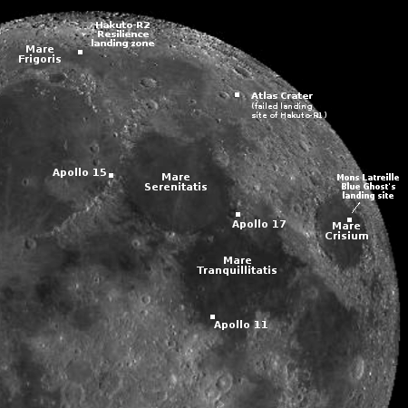
Landing sites for both Firefly’s Blue Ghost and
Ispace’s Resilience
I have embedded the live stream below of the landing of the Japanese startup Ispace’s Resilience lunar lander, presently scheduled to occur at 3:17 pm (Eastern) today (June 6, 2025 in Japan).
The live stream goes live at about 2:00 pm (Eastern).
Resilience will attempt to land on the near side of the Moon at 60.5 degrees north latitude and 4.6 degrees west longitude, in the region dubbed Mare Frigoris (Latin for “the Sea of Cold”), as shown on the map to the right. That map also shows a number of other landings on this quadrant of the Moon, including Ispace’s previous failed attempt with its first lander, Hakuto-R1, in Atlas Crater in 2023.
For Ispace, today’s landing is critical for its future. It has contracts for future three landers with NASA, with Japan’s space agency JAXA, and with the European Space Agency, but a failure today could impact whether those contracts proceed to completion.
» Read more


