German students about to attempt launch of suborbital hybrid rocket

A student project at the University of Stuttgart in Germany is about to attempt the first suborbital launch of a hybrid rocket that has the possibility of setting a new altitude record for student-built rockets.

The hybrid rocket is 7.80 m long and weighs around 70 kg. It was built by around 60 students from the University Group HyEnD of the University of Stuttgart. “It’s one of the most powerful and advanced student-built hybrid rockets in the world,” says Max Öchsle, HyEnD project manager. With this, the students have big plans: They want to beat their own altitude record of 32 km for student-built hybrid rockets, which they set in 2016.

The students also hope to cross the boundary into space at an altitude of 100 km. In addition to the world record for hybrid rockets, this also makes the world record for student-built rockets in general possible. The previous record is 103.6 km and was set by the University of Southern California (USCRPL) team in 2019. “The world record is within our reach. We could indeed beat it,” says Öchsle. Öchsle is well aware that the record depends on other factors such as the weather.

The launch window begins on April 14th, and extends until April 25th, will take place at the new Esrange commercial spaceport in Sweden, and will be live streamed by the spaceport. Updates on the project can be found at the project’s own website.

What makes this particular student project interesting to me is its location, in Germany. That nation presently has three startup rocket companies racing to be the first to reach orbit. These students are clearly aiming for jobs with this emerging German rocket industry, and if successful at this project will bring to that industry some very sophisticated abilities.

Museum offers $25k for recovery of meteorite that landed in Maine April 8th

Meteorite landing track

Because a instrument operated by NOAA picked up radar data of an asteroid fall over Maine on April 8, 2023, it has been possible for NASA scientists to publish a track, shown to the right, of where any pieces of the meteorite might have landed.

As a result, the Maine Mineral and Gem Museum has offered a $25k reward to anyone who turns in the first piece weighing more than one kilogram.

The $25,000 reward is only for the first kilogram, but Pitt said that the museum will also buy other fireball pieces that are found. “Depending upon the type of meteorite this is, specimens could easily be worth their weight in gold,” he said.

The American Meteor Society received six witness reports of Saturday’s fireball, half of which were in northeast Maine. One of the witnesses described the meteorite as having a “long glowing tail (but no smoke).” Another said that it was “bright red” while the tail was “very white.”

The museum also emphasized that any meteorite hunters must get landowner permission before entering private land.

Hakuto-R1 now scheduled to land on Moon on April 25th

Lunar map showing Hakuto-R1's landing spot
Hakuto-R1’s planned landing site is in Atlas Crater.

The private company Ispace yesterday announced that their Hakuto-R1 lunar lander, presently in orbit around the Moon, will attempt a landing on April 25, 2023, landing in Atlas Crater.

At approximately 15:40 on April 25, 2023, (UTC), the lander is scheduled to begin the landing sequence from the 100 km altitude orbit. During the sequence, the lander will perform a braking burn, firing its main propulsion system to decelerate from orbit. Utilizing a series of pre-set commands, the lander will adjust its attitude and reduce velocity in order to make a soft landing on the lunar surface. The process will take approximately one hour.

Should conditions change, there are three alternative landing sites and depending on the site, the landing date may change. Alternative landing dates, depending on the operational status, are April 26, May 1, and May 3, 2023.

The lander carries several commercial payloads, including the United Arab Emirates (UAE) Rashid rover. Ispace says the landing will be publicly live streamed, with more details to follow.

The company has from the beginning been treating this entire mission as an engineering test, with ten major goals, all related to proving out the lander’s systems. It has now completed eight of those goals, with a successful landing and successful operations on the surface the last challenges. If Hakuto-R1 succeeds, Ispace will become the first private company to complete a privately funded planetary mission to the Moon.

Furthermore, the company is already planning its second lunar landing mission, Hakuto-R2 in 2024, and a third more ambitious lunar mission for NASA, partnering with the American company Draper.

Triple crater on Mars

Triple crater on Mars
Click for original image.

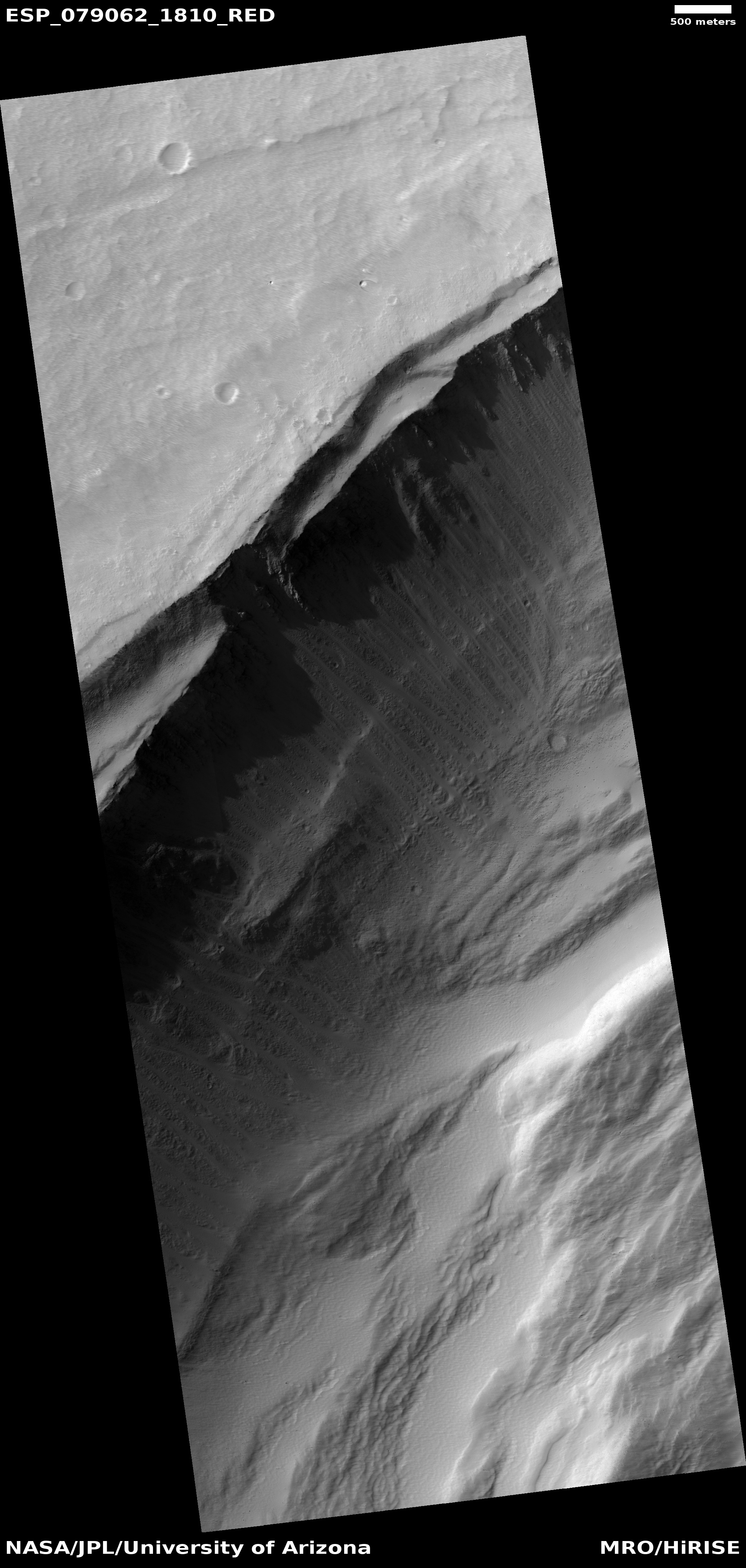
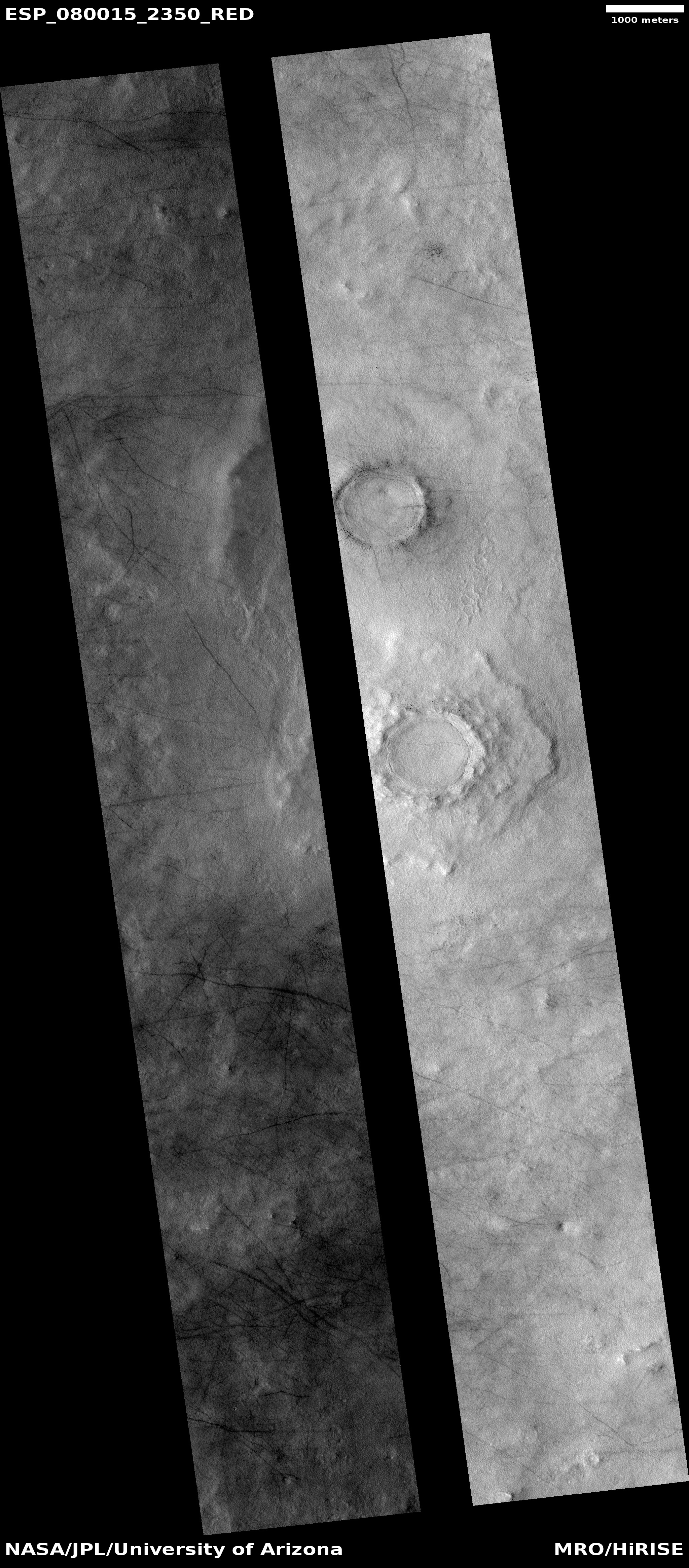
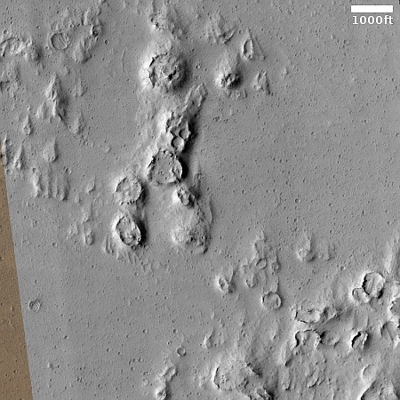
Cool image time! The picture to the right, cropped, reduced, and sharpened to post here, was taken on January 22, 2023 by the high resolution camera on Mars Reconnaissance Orbiter (MRO). It shows what the scientists have labeled simply as a “triple crater,” a very apt description.

What caused this? The most obvious explanation is the arrival almost simultaneously of three pieces. As this asteroid or comet entered the thin Martian atmosphere as a single object, that atmosphere was thick enough to break it into three parts but not enough to destroy it entirely. When it hit the ground, the top piece hit first, with the center and bottom pieces following in sequence, thus partly obscuring the previous hits.

The smaller surrounding craters could either be additional pieces from the bolide, or secondary impacts from ejecta thrown out at impact.
» Read more

Relativity ends Terran-1, will move to developing more powerful Terran-R

According to Tim Ellis, the head of the rocket company Relativity, it has decided to end any further work on its small test rocket, Terran-1 following its first failed launch and shift all work to developing its more powerful Terran-R rocket.

The company feels good about the data collected from the flight, as Terran 1 made it further into space than the debut launches from a majority of small rocket companies. It also validated the company’s test and launch program, he said, and its approach to 3D printing large parts of a rocket. “Terran 1 was always meant to develop technologies that were pushing the bounds for what was needed for Terran R,” Ellis said.

But now, it’s time to move on. Relativity Space is negotiating with NASA to move the one existing commercial launch on Terran 1—the Venture Class Launch Services Demonstration 2 mission—onto another rocket, possibly the Terran R. In other words, there will be no more Terran 1 launches.

Ellis also described some major changes in the design of Terran-R. The company will no longer attempt to make the second stage reusable, it will no longer 3D-print its entire structure, its first stage will be more powerful and will be flown and reusable like SpaceX’s Falcon 9, and its first launch will be pushed back from 2024 to 2026.

This decision means that Relativity will not become an operational and competitive rocket company for another three years, at the soonest. However, should it succeed in achieving these new plans for Terran-R, it will have a rocket that can directly compete with SpaceX, while beating out anything either ULA or Blue Origin can at this time offer. For example, the rocket will be able to put from 23 to 33 tons into low Earth orbit, which is more than the Falcon 9 (20 tons) and not much less than the Falcon Heavy (50 tons), and generally better than Vulcan (27 tons). As noted at the link:

[T]he US government (as well as commercial satellite customers) would very much like a second company to step forward and challenge SpaceX on innovation, price, and reliability. Ellis correctly sees that this lane remains open with questions about Vulcan’s long-term future, Blue Origin’s slow movement on New Glenn, and Rocket Lab’s focus on a smaller medium-lift rocket, Neutron.

Whether this new strategy will work depends entirely on whether Relativity can deliver by 2026. If it does so, it will very likely beat Blue Origin into orbit, and be chosen by the military to replace it as one of the Pentagon’s launch providers. It will also make ULA’s position more vulnerable, because Vulcan will no longer be the only other option, and it will likely not be able to compete with the prices offered by SpaceX and Relativity.

SpaceX announces it will be providing a webcast for Starship’s first orbital flight

Starship/Superheavy flight plan for first orbital flight
Click for original image.

SpaceX today revealed the details for its live stream of the first orbital launch of Superheavy/Starship, now targeting a launch date around April 21, 2023, depending on when the FAA issues the launch license.

A live webcast of the flight test will begin ~45 minutes before liftoff. As is the case with all developmental testing, this schedule is dynamic and likely to change, so be sure to stay tuned to our social media channels for updates.

I will embed that live stream here on Behind the Black. Stay tuned for more information.

The flight plan is shown above. The website also provides a detailed timeline. If launch manages to pass through Max-Q and get to stage separation, Superheavy will do a flip to do a soft targeted landing in the Gulf of Mexico. Starship will continue into orbit, and then fire its engines to return to Earth to do a soft targeted landing in the Pacific northeast of the Big Island of Hawaii.

That is the plan. Much can go wrong along the way, considering Superheavy has never flown once, no less with Starship stacked on top. Furthermore, Starship has never flown in its present iteration. Previous suborbital tests were using much earlier prototypes vastly different that this prototype, #24 in the series.

Regardless whether all goes perfectly or some things fail, the launch will be a success because it will provide SpaceX data for future test flights, which are waiting in the wings.

Weird surface cracking in the Martian northern lowland plains

Weird surface cracks on Mars

Cool image time! The picture to the right, cropped, reduced, and enhanced to post here, was taken on January 15, 2023 by the high resolution camera on Mars Reconnaissance Orbiter (MRO). The picture was simply labeled “Channel-like feature”, which hardly describes this strange terrain.

Apparently a mantle of surface material has covered and filled an ancient east-west channel. That surface material however has since cracked along the edges of that channel as well along its length. The cracks suggest that the material in the channel is moving downhill slowly, cracking along the cliff walls while also being pulled apart to form the north-south cracks.

My regular readers will I think be able to guess what is going on here, but if you can’t, the overview map below will help explain this.
» Read more

Startup aims to provide Space Force a satellite that can study the satellites of other countries

True Anomaly, a Colorado-based startup, has proposed building satellites for the Space Force designed to maneuver close to other satellites and provide high resolution imagery and data about them.

The company has already raised $30 million, and used it to hire 57 employees and a facility for manufacturing these satellites.

The startup plans to use the funding to scale the production of its Jackal Autonomous Orbital Vehicle, which was designed to study space objects at close range. The spacecraft collects photos, videos and data about any space objects in orbit, and it’s operated by humans with the assistance of artificial intelligence pilots.

Both China and Russia have flown a handful of satellites testing this exact technology. The U.S. has not, at least nothing comparable in recent years.

The real story here however is the manner in which the Space Force will do this. Instead of designing and building the satellites itself, which has been the policy of the military for decades, the Space Force is following the recommendations in my 2017 policy paper, Capitalism in Space, and becoming merely a customer, letting private companies do the work and own it themselves.

Startup proposes capturing space junk with a satellite operating like a whale

Paladin satellite capturing space junk

Paladin, a new space junk removal startup based in Australia, has now proposed building a satellite that would literally swallow space junk and then send it over the ocean to burn up.

The image to the right shows the satellite as a piece of junk is about to be captured. The advantage it has on all other designs for capturing space junk is its simplicity. No nets, no harpoons, no grappling arms. The debris is captured inside a box inside the satellite, and then that box is released to burn up. This quote from the startup’s founder and CEO, Harrison Box, illustrates well his investment argument:

“The European Space Agency is currently paying 100 million euros to remove just one item of space junk. That’s the value they put on the job,” says Box. “Imagine the value of being able to remove hundreds.”

Paladin is one of 29 startups that have divided up $14 million in development money provided by a program of the Australian government. Thus, it is only at the very beginning of development, without a lot of cash to work with.

The idea however is smart, with great potential.

Starship orbital test flight delayed one more week due to FAA delays

According to a tweet yesterday by Elon Musk, the first orbital test flight of Starship/Superheavy has been delayed again.

Starship launch trending towards near the end of third week of April

Musk had made it clear in an April 8th tweet the cause of this delay or any other delays:

Starship is ready for launch. Awaiting regulatory approval

Musk needs to be somewhat diplomatic as it will not help him to make federal bureaucrats his enemies. What he is doing here is subtly letting everyone know the sole cause of the delay, in order to press the FAA to get a move on, without saying so directly. He leaves that to others, such as myself, to say it instead.

I fear that the FAA is now demanding that it must look at the data from any wet dress rehearsal countdown, including the short engine burst that Superheavy will likely do at T-0, before it will issue the permit. If so, we could see more than a week delay. The launch should easily slip to late May if not later.

The absurdity of this is that it is utterly pointless for FAA bureaucrats to look at any of this data. What do they know? Nothing. If something was significantly wrong SpaceX engineers would know far sooner, and delay the launch themselves.

The delays seen in issuing this one launch license however give us a nice picture of what it will be like for the launch industry once the moratorium on heavy regulations by the FAA and other federal agencies expires on October 1, 2023. Expect a substantial slowdown in development and launches, with many of the new companies about to become operational instead going bankrupt in a replay of the destruction of Virgin Orbit by the UK’s Civil Aviation Authority.

Exploring the cratered southern highlands of Mars, part 4

Overview map

Gullies in Asimov Crater
Click for full image.

Today is the last part in our four part exploration of the cratered southern highlands of Mars, begun last week. (For the early parts, go here-Part #1, here-Part #2, and here-Part #3.) Though there is no need, new readers should read the first three parts first, in order to get the larger perspective of this final post.

The picture to the right, rotated, cropped, reduced, and sharpened to post here, was taken on December 20, 2022 by the high resolution camera on Mars Reconnaissance Orbiter (MRO). It shows the eastern main gully descending down into a pit that sits in the north center of 52-mile-wide Asimov Crater, as shown in the inset on the overview map above. (For an MRO high resolution of the western gullies into this pit, see this January 2019 cool image post.)
» Read more

Report recommends Congress allow full regulation of commercial human spaceflight

The modern instruction manual for America

A new report by the RAND corporation has recommended that Congress allow the moratorium on full regulation of commercial human spaceflight, established by the Commercial Space Launch Amendments Act of 2004 and extended several times, to expire on October 1, 2023.

That recommendation came despite a lack of progress on voluntary standards and key industry metrics. While standards development organizations like ASTM International and ISO have published 20 standards related to commercial spaceflight, the RAND report noted that “companies have yet to clearly or consistently adopt them in a manner that can be confirmed or verified publicly.” A diversity of technical approaches also hinders the development and implementation of standards.

The report also found that while the FAA had developed key industry indicators to assess readiness for adopting safety regulations, there were no goals for those indicators to determine when it was time to implement regulations. “It is, therefore, difficult to assess whether there has been progress toward meeting key industry metrics when there are not clear targets that could be met,” the report concluded.

Despite that lack of progress on standards or metrics, the RAND report nonetheless concluded that allowing the learning period to expire this year was the best approach. Doing so, it argued, would allow FAA and industry to start the process of developing safety regulations in a gradual manner and avoid a rush to regulate imposed by Congress should a high-profile accident take place while the learning period is still in effect.

It also recommended additional resources for the FAA to support that regulatory process, but did not quantify an increase in the budget for or personnel assigned to its Office of Commercial Space Transportation, or AST. [emphasis mine]

The highlighted words illustrate the crushing fundamentals of all government regulation. » Read more

The Earth hangs above the Moon

The Earth hangs above the Moon

Cool image time! The picture to the right, cropped, reduced, and enhanced to post here, was taken by Lunar Reconnaissance Orbiter (LRO) on December 10, 2015 and released by the LRO team this week. From the caption:

LRO slewed to the east as it passed over the northwest rim (-8.536°N, 251.028°E, 82 km altitude) of the Orientale basin and snapped this spectacular Earth-Moon sequence with the NAC and WAC [cameras]. Tropical Cyclone Bohale is visible in the center of the image. MODIS (onboard the NASA Aqua satellite) imaged the same storm 3 hours after LRO.

The NAC and WAC images of the Earth were projected using a Point-Perspective projection to recreate the view one would see from the LRO spacecraft while taking the NAC image. Due to the relatively slow speed of the spacecraft slew, many NAC framelets of the Earth were acquired. All these WAC frames were oversampled and averaged, enabling a “super-resolution” color image (115 pixels across!), which was then combined with the 4000-pixel-wide NAC image.

…[For the Earth:] North is to the left, Antarctica to the right, Australia at the top, and Africa at the bottom

NAC and WAC are names of two different LRO cameras, one of which captured the Earth in high resolution color while the other captured the Moon. The two images were then combined, superimposing the Earth at the right size onto the second lunar image.

As noted in the caption, this view is as LRO sees the Earth from Lunar orbit, while taking a slewed oblique image of the Moon. It however is not how things would look if you were standing on the surface of the Moon. For one, the photo is zoomed in to get details on the lunar surface, making the Earth appear much larger.

For another, the image is taken 82 kilometers or 51 miles above the Moon. This higher altitude changes the position of the Earth relative to the Moon, making it appear farther from the horizon.

To a person standing in Orientale basin at 8 degrees south latitude (near the equator), but also near the edge of the visible near side of the Moon, the Earth would likely be very close to the horizon, but much smaller. To get a comparable view of the Earth, the person would likely need to use binoculars.

Orientale basin is mostly on the far side of the Moon, though it was known to exist before the space age because ground-based telescopes could see it on the edge of the visible face. It was only with the first lunar orbiters was the basin imaged from directly above, revealing its large size and distinct concentric rings forming its several circular rims.

At this location, the Earth would essentially always remain at approximately the same spot in the sky, though its illuminated face would wax and wane, like the Moon’s does, during the Moon’s twenty-eight day-long day.

Exploring the cratered southern highlands of Mars, part 3

Overview map

Pit and surface in crater
Click for original image.

This is the third part of this week’s series taking a look at some of the strange features in the southern cratered highlands of Mars. In the first part I posted a beautiful image of what appears to be a crater filled to the brim with glacial ice, surrounded by an ice sheet plain. In part two we took a look at the interior of Rabe Crater, which though very nearby does not appear to have obvious glacial features within it at all. What it has instead are deep open air pits and a lot of sand dunes.

Today’s image to the right, cropped, reduced, and sharpened to post here, takes us to the interior of an unnamed 45-mile-wide crater only about 70 miles north of Rabe. The black dot in the inset on overview map above indicates the photo’s location. The picture was taken on January 1, 2023 by the high resolution camera on Mars Reconnaissance Orbiter (MRO). Like Rabe, this crater also has many large open-air pits. In the picture one pit, near the lower center of the picture, is surrounded by soft-looking mounds and a strangely swirling textured and uneven terrain that makes up the majority of the crater’s floor.

This picture might help explain what we saw in Rabe. The textured terrain in this unnamed crater could easily be ice-impregnated and now hardened sand dunes. The pit could be where that impregnated ice has sublimated away, leaving behind the dust from those ancient dunes which then forms new sand dunes. In Rabe, the crater floor above its pits looks very similar to this swirling textured surface, suggesting the same process is going on there.

What strengthens this explanation is the many other craters nearby, all indicated by red dots in the overview map above, that also have pits or distorted crater floors. Their proximity suggests that there is an underground ice layer in this region, always at about the same elevation, and each crater impact exposed it. With time that exposed ice, no longer pure but filled with material from the impacts, sublimated partly away, producing the pits as well as ample sand to form sand dunes.

Starship now stacked on launchpad

Starship stacked on top of Superheavy

In preparation for a final wet dress rehearsal countdown followed by its first launch, Starship has now been stacked on top of Superheavy at SpaceX’s launchpad at Boca Chica, Texas.

The picture to the right is a screen capture from a short video Elon Musk posted on Twitter. SpaceX had also tweeted that its “Team is working towards a launch rehearsal next week [April 10-11] followed by Starship’s first integrated flight test ~week later pending regulatory approval.”

At this time the FAA has still not issued the launch license. By announcing its plan to launch the week of April 17th, Musk and SpaceX puts pressure the government bureaucracy to get a move on.

Axiom sets date for next commercial manned flight to ISS

Axiom and NASA yesterday announced May 8, 2023 as the launch date for the private company’s second commercial flight to ISS, this time carrying three passengers out of a crew of four, two from Saudi Arabia and the third, John Shoffner, completing his second paid flight with Axiom.

Two of its crewmates are Rayyanah Barnawi and Ali AlQarni, members of the first Saudi Arabian astronaut class. Barnawi will become the first Saudi woman ever to reach space, and she and AlQarni will be the first people from the kingdom to travel to the ISS.

Retired NASA astronaut Peggy Whitson will command the mission for Axiom. The Dragon capsule used will be Freedom, making its second flight, lifting off on a Falcon 9 rocket with a new first stage. The plan is to be docked to ISS for ten days, which means for that time period ISS will have three Arab astronauts on board, including the UAE’s astronaut, Sultan Al Neyadi, who is in the middle of a six month mission and is about to do his first spacewalk.

Chinese pseudo-company succeeds in reaching orbit again after three straight failures

China's spaceports
China’s spaceports

The Chinese pseudo-company I-space has finally reached orbit again with a launch today of its Hyperbola-1 (SQX-1) solid-fueled rocket, lifting off from China’s Jiuquan inland spaceport in the Gobi Desert.

After an initial launch success in 2019, the company had failed three straight times until today. No word on whether the first stage landed near habitable areas in China. Nor did the pseudo-company reveal whether the rocket carried an actual satellite into orbit.

Jiuquan is presently the only spaceport where China permits these pseudo-companies to launch, and has been expanding its facilities for these commercial operations. This also means China will be experiencing more first stages dropping on their heads of its people, which is why it is also building a commercial launchpad at the Wenchang spaceport on the coast.

The leaders in the 2023 launch race:

23 SpaceX
15 China
6 Russia
3 Rocket Lab

American private enterprise now leads China 26 to 15 in the national rankings, and the entire world combined 26 to 25. SpaceX now trails the rest of the world combined, including American companies, 23 to 28.

UPDATE from BtB’s stringer Jay: Video of the launch can be found here. Jay also notes the lack of any mention of I-space in the official Chinese press, announcing this launch. Adds weight to the conclusion that these companies are not really real, but simply divisions of the Chinese government.

SpaceX successfully launches Intelsat communications satellite

SpaceX tonight successfully used its Falcon 9 rocket to launch an Intelsat communications satellite into orbit, lifting off from Cape Canaveral.

The first stage completed its fourth flight, landing on a drone ship in the Atlantic. The two fairings completed their second and eighth flights.

The leaders in the 2023 launch race:

23 SpaceX
14 China
6 Russia
3 Rocket Lab

American private enterprise now leads China 26 to 14 in the national rankings, and the entire world combined 26 to 24. SpaceX now trails the rest of the world combined, including American companies, 23 to 27.

April 6, 2023 Quick space links

Courtesy of BtB’s stringer Jay.

  • China invites Brazil to participate in its lunar base project
  • There is no indication Brazil accepted the offer. The offer took place during a meeting between officials of the Brazil Space Agency and one of China’s pseudo-companies, China Great Wall Industry Corporation (which according to Jay “is the international launch service subsidiary” for China). Thus, this could be an effort by that pseudo-company to gain launch access to Brazil’s recently reactivated Alcântara spaceport.


Exploring the cratered southern highlands of Mars, part 2

Overview map

Dune-bedrock contact in Rabe Crater
Click for original image.

Our travels in the cratered southern highlands of Mars continues. Today we visit 67-mile-wide Rabe Crater, as indicated on the overview map above. The picture to the right, cropped and reduced to post here, was taken on January 27, 2023 by the high resolution camera on Mars Reconnaissance Orbiter (MRO).

Rabe Crater is significant for several reasons. First, it was one of the first places on Mars where sand dunes were identified, by one of the Viking orbiters in the late 1970s [pdf]. Second, the pits and sand in its interior, are unusual and puzzling. The inset on the overview map provides a closeup look at the crater. The yellow mound in the central south of the crater floor is all dunes, which are surrounded by the pit with steep cliffs more than a 1,000 feet high.
» Read more

University of Arizona opens major facility for building and launching satellites

anechoic chamber at UA's Applied Research Building
ARB’s anechoic chamber

Yesterday I attended the grand opening of the University of Arizona’s (UA) new Applied Research Building (ARB), designed to provide satellite builders as well as its students an almost completely comprehensive facility for the assembly, testing, and launching of satellites. From this event announcement:

To keep the university at the forefront of space science and exploration, ARB will serve as a world-class test and integration center for satellites, probes, and spacecraft, including:

  • A 40-foot tall high-bay payload assembly area used for constructing high-altitude stratospheric balloons and nanosatellites also known as “CubeSats.”
  • A thermal vacuum chamber that simulates environmental conditions in space to test balloon and satellite performance that is the largest of its kind at any university in the world.
  • A non-reflective, echo-free room called an anechoic chamber to test antennae for command, control, and data relay purposes.
  • A large lab for testing the performance of a range of objects, from airplane wings to sensors.

The anechoic chamber is pictured above. For scale, if a person was standing in the middle of the chamber their height would reach about six rows up. The carbon-infused styrofoam pyramids are designed to dampen reflections of radio signals in order to simulate the space environment while testing the antennas on a satellite. This is apparently is of the largest such chambers in the United States.
» Read more

Webb snaps infrared picture of Uranus

Uranus as seen in the infrared by Webb
Click for original Webb false-color image.

In a follow-up to a recent Hubble Space Telescope optical image of Uranus, scientists have now used the Webb Space Telescope to take a comparable picture in the infrared of the gas giant.

Both pictures are to the right, with the Webb picture at the top including the scientists’ annotations.

On the right side of the planet there’s an area of brightening at the pole facing the Sun, known as a polar cap. This polar cap is unique to Uranus – it seems to appear when the pole enters direct sunlight in the summer and vanish in the fall; these Webb data will help scientists understand the currently mysterious mechanism. Webb revealed a surprising aspect of the polar cap: a subtle enhanced brightening at the center of the cap. The sensitivity and longer wavelengths of Webb’s NIRCam may be why we can see this enhanced Uranus polar feature when it has not been seen as clearly with other powerful telescopes like the Hubble Space Telescope and Keck Observatory.

At the edge of the polar cap lies a bright cloud as well as a few fainter extended features just beyond the cap’s edge, and a second very bright cloud is seen at the planet’s left limb. Such clouds are typical for Uranus in infrared wavelengths, and likely are connected to storm activity.

The Webb image also captures 11 of Uranus’s 13 rings, which appear much brighter in the infrared than in the optical.

Unlike all other planets in the solar system, Uranus’s rotation is tilted so much that it actually rolls as it orbits the Sun, a motion that is obvious by comparing these pictures with Hubble’s 2014 optical picture.

China tests vertical landing of small rocket from barge at sea

China's own version of SpaceX's Grasshopper

A commercial division of the Chinese Academy of Sciences (CAS) has successfully test flown its own a very small version of SpaceX’s Grasshopper, doing a vertical lift off from a barge at sea and then landing vertically on that barge.

The rocket prototype flew at an altitude of more than 1,000 meters, descended in a smooth hovering fashion and then decelerated thanks to the engine reverse thrust. The landing speed was reduced to less than two meters per second at the final stage before the rocket touched down steadily with a landing precision of under 10 meters.

The landing test took about 10 minutes, the CAS institute revealed.

The small scale of the rocket, as shown by the screen capture above, taken from the short video CAS produced of the flight, shows that CAS is a long way yet from using this technology in an orbital flight. Nonetheless, it demonstrates that at least two Chinese pseudo-companies are working hard to copy SpaceX’s reusable Falcon 9 first stage. With this test CAS has demonstrated it now has the software and fine engine control for vertical rocket landings. Based on the image of its proposed rockets at this tweet, this prototype will eventually lead to the development of larger orbital versions that look remarkably similar to what SpaceX produces.

Spaceplane startup flies small-scale prototype for the 1st time using new rocket engine

The startup Dawn Aerospace, based in New Zealand, has now successfully flown a small-scale prototype of its proposed spaceplane using for the first time the company’s Aurora rocket engine.

Mk-II Aurora, a scaled down version of the spaceplane Dawn is developing for commercial operations, took to the skies March 29, 30 and 31 from New Zealand’s Gentanner Aerodrome. The initial test campaign validated key flight systems and demonstrated the benefit of rapid reusability, Dawn CEO Stefan Powell told SpaceNews.

During the first flight, the Mk-II Aurora consumed more fuel than anticipated due to a leak in the propellant system. The next day, Dawn engineers removed the Mk-II Aurora engine, took out the oxidizer tank and found the leak.

These rocket-powered test flights are a follow-up of an earlier test program in 2021 using jet engines. You can get a sense of the scale of the prototype from a picture at this article.

The company plans to fly this prototype to as high as twelve miles later this year before moving on to a larger test version. Eventually it hopes to develop a two-stage orbital system. The details however remain vague. The 2021 release suggested it was building a two-stage-to orbit version that will take off from a runway and then launch small satellites into orbit. These new stories suggest it are presently targeting the suborbital unmanned research market, with the eventual ability to do frequent flights to 70 miles altitude. Launching orbital satellites is presently only a distant goal.

April 5, 2023 Quick space links

Courtesy of BtB’s stringer Jay.


  • Tianzhou freighter will fly in formation with China’s Tiangong-3 space station
  • The plan is to periodically redock the freighter to the station “when inventories stored inside are needed.” Jay wonders whether this is a test of the similar formation flying that will be required when China’s space telescope arrives next year to orbit near the station for periodic maintenance and repair. I think he is correct.

Exploring the cratered southern highlands of Mars, part 1

Overview map of southern cratered highlands of Mars

Glacial filled crater
Click for original image.

Today and for the next three days the cool images that I will post from Mars will explore a region that I have not covered very much in depth, the cratered southern highlands between the giant basins Argyre and Hellas. The map above is an overview of this 7,000-mile-long region, all of which is inside the 30 to 60 degree south latitude band where scientists have found much evidence of buried glaciers. In this region the bulk of that evidence is most obvious inside craters.

The picture to the right, cropped, reduced, and sharpened to post here, was taken on December 21, 2022 by the high resolution camera on Mars Reconnaissance Orbiter (MRO), and shows a typical example of the kind of glacial feature found. The white cross on the map marks its location, west of the Hellespontus Mountains that form the western rim of Hellas Basin.

Scientists have dubbed this feature concentric crater fill, a purposely vague term because — though it looks like glacial fill — until there is data to confirm it the scientists would quite properly rather not commit themselves. The concentric rings suggest multiple layers, each of which likely marks a different climate cycle in Mars’ geological history.

In this case the glacier features also appear to cover the entire plain surrounding the crater as well as its rim. The small crater to the west is similar, and both give the appearance that the ice sheet that covers them came after the impact, draping itself over everything, with the craters only visible because the ice sheet sags within their interiors.

More crazy features from the cratered highlands to come.

First binary quasar found

Double quasar as seen by the Hubble Space Telescope

Using a suite of telescopes on the ground and in orbit, astronomers have found the first galaxy made up of two quasars, supermassive black holes that are very active in eating material from around them.

ESA’s (European Space Agency) Gaia space observatory first detected the unresolved double quasar, capturing images that indicate two closely aligned beacons of light in the young universe. Chen and his team then used NASA’s Hubble Space Telescope to verify the points of light were in fact coming from a pair of supermassive black holes.

Multi-wavelength observations followed; using Keck Observatory’s second generation Near-Infrared Camera (NIRC2) paired with its adaptive optics system, as well as Gemini North, NASA’s Chandra X-ray Observatory, and the Very Large Array network of radio telescopes in New Mexico, the researchers confirmed the double quasar was not two images of the same quasar created by gravitational lensing.

The two quasars are estimated to be only about 10,000 light years apart. Scientists estimate that this galaxy is about ten billion light years away, and exists in this state only about three billion years after the Big Bang.

Shetland Spaceport now faces same regulatory hurdles that destroyed Virgin Orbit

The new Shetland spaceport, Saxavord, is right now attempting to get launch approvals from United Kingdom’s Civil Aviation Authority (CAA), the same agency that dithered for six months approving a Virgin Orbit launch, thus causing the bankruptcy of that company.

According to Saxavord’s CEO, the spaceport has two launches aiming to launch before the end of this year, assuming the CAA can get its act together and give its approval. This quote however is worrisom:

The Saxavord spaceport says it is “still on track” to receive its necessary licences from the sector’s regulator before the summer. This relates to applications to the Civil Aviation Authority for range and spaceport licences.

Meanwhile SaxaVord CEO Frank Strang said the company is also on track for two rocket launches this year – “albeit they have moved slightly to the right”. [emphasis mine]

The delays could be coming from the rocket companies themselves. One of those companies is the German startup, Rocket Factory Augsburg, which has leased exclusive use of one launchsite. The other is the American startup ABL, which has had one launch attempt from the U.S. that failed.

Based on the CAA’s track record however the delays are just as likely coming from it. The CAA began this licensing process in November 2022, and is not done yet six months later.

Scientists try to model what would happen if Ryugu hit Earth

Ryugu's northen hemisphere
Ryugu’s northen hemisphere. The arrow marks the spot Hayabusa-2
gathered samples

Scientists, using the data and rock samples gathered by the Japanese probe Hayabusa-2, have attempted to predict what what would happen if the rubble-pile asteroid Ryugu hit the Earth.

Without diversion intervention, Tanaka explained, if the Ryugu asteroid was heading to Earth and entered the planet’s atmosphere at an angle of 45 degrees and at a speed of around 38,000 miles per hour (17 kilometers per second), the rubble pile asteroid would break up at an altitude of around 25 to 21 miles (40 to 35 km) over the surface of the planet.

This would result in an “airburst” similar to that seen over Russia in February 2013 when the Chelyabinsk meteor erupted at an altitude of around 19 miles (30 kilometers) over Earth. The result of the Chelyabinsk blast was a bright flash of light and an atmospheric blast equivalent to the detonation of 400–500 kilotons of TNT. This is as much as 33 times the energy released by the atomic bomb that devastated Hiroshima at the end of the Second World War.

The Chelyabinsk meteor caused about 1,500 injuries, mostly from people injured by glass thrown out by breaking windows when it suddenly and unexpectedly exploded during re-entry. With Ryugu this would not be a surprise, so these injuries could be reduced, though not eliminated. The damage and injuries from pieces that survived the breakup and hit the ground remains unknown because scientists don’t know how much of the asteroid would survive the break up.

Ryugu of course poses no threat, because it is not on a collision course with Earth. Whether an asteroid like Ryugu could be diverted however remains unknown, since any such diversion must not cause the asteroid to break apart as well.

The outermost edge of Mars’ north polar icecap

The outermost edge of Mars' north polar icecap
Click for original image.

Cool image time! The picture to the right, rotated, cropped, reduced, and sharpened to post here, was taken on February 4, 2023 by the high resolution camera on Mars Reconnaissance Orbiter (MRO). It shows the terminating cliffs of the north pole ice cap of Mars, dubbed Rupes Tenius on this side of the icecap.

At this point the elevation difference of the icecap’s edge from top to bottom is not significant, only about 1,500 feet or so, though this is a very rough estimate. As with all other images of the ice cape’s edge, there are many many layers visible, all indicating a different cycle in the climate history of Mars as its rotational tilt swings from about 11 degrees to 60 degrees over eons.

Moreover, at this point there is likely not that much difference between the terrain on top and the terrain below. Both will be mixed ice and dust and coarse rocks, though the percentages will be shifting towards less ice as we go down.
» Read more

1 98 99 100 101 102 506