
New study using Chandrayaan-2 data again suggests ice in crater near Moon’s south pole
The uncertainty of science: A new study by scientists in India using data from the Indian lunar orbiter Chandrayaan-2 has once again found evidence strongly suggesting the existence of water ice in several permanently shadowed craters near Moon’s south pole.
The findings are based on observations made by the Chandrayaan-2 orbiter’s Dual Frequency Synthetic Aperture Radar (DFSAR), a sophisticated microwave imaging instrument capable of probing beneath the lunar surface.
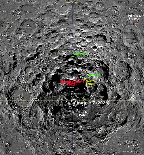
Among the craters examined, scientists found particularly strong evidence of subsurface ice in a 1.1-kilometre-wide crater located within the larger Faustini crater near the Moon’s south pole. Researchers said the crater displayed a distinctive “lobate-rim morphology”- a flow-like structural pattern that may indicate the impact event penetrated an ice-rich subsurface layer.
On the map above the green dot to the right of the south pole marks the location of the small crater inside Faustini Crater. Their conclusions were based first on microwave data suggesting subsurface ice, and second on the lobate shape of this crater’s rim, which has a kind blobby look implying the material is muddy and impregnated with ice.
Increasingly the data from all sources seems to suggest that if there is ice in these permanently shadowed craters, it is likely impregnated in the soil, and will require processing to extract.


