
Parker makes 28th close fly-by of the Sun
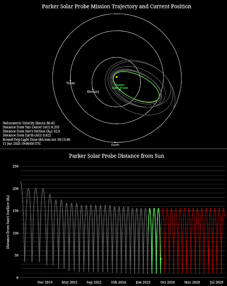
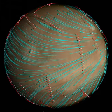
The overall flight plan for Parker. The green indicates
this most recent close approaches.
The Parker Solar Probe this past week successfully completed its 28th close fly-by of the Sun, zipping past its surface at a distance of only 3.8 million miles.
During this solar encounter, which started June 3 and ends Saturday, June 13, Parker’s four scientific instrument packages gathered data from inside the Sun’s atmosphere, or corona. Parker will begin returning detailed spacecraft telemetry on June 14, with science data transmission set to run from Wednesday, June 17 to Tuesday, June 30.
…Parker also equaled its record-setting speed of 430,000 mph — a mark that, like Parker’s distance to the Sun, was set during a close approach on Dec. 24, 2024, and matched during five flybys since, most recently on March 11. Parker will continue matching these speed and distance records during future flybys.
Engineers estimate the spacecraft’s heat shield experiences temperatures exceeding 1,700 degrees Fahrenheit with each close pass.
With each pass the spacecraft dives deep into the Sun’s corona and gathers data about it unobtainable from a distance. It is also gathering that data over time, as it first arrived in 2018, when the Sun was at its solar minimum with little sunspot activity. Since then it has ramped up to maximum and is presently thought to be on its way back down to minimum (though this still remains uncertain). Parker’s ability to gather data cross this timeline is invaluable for gaining a better understanding of the Sun’s behavior.


