
Cliffs of Martian ice

Click for full image.
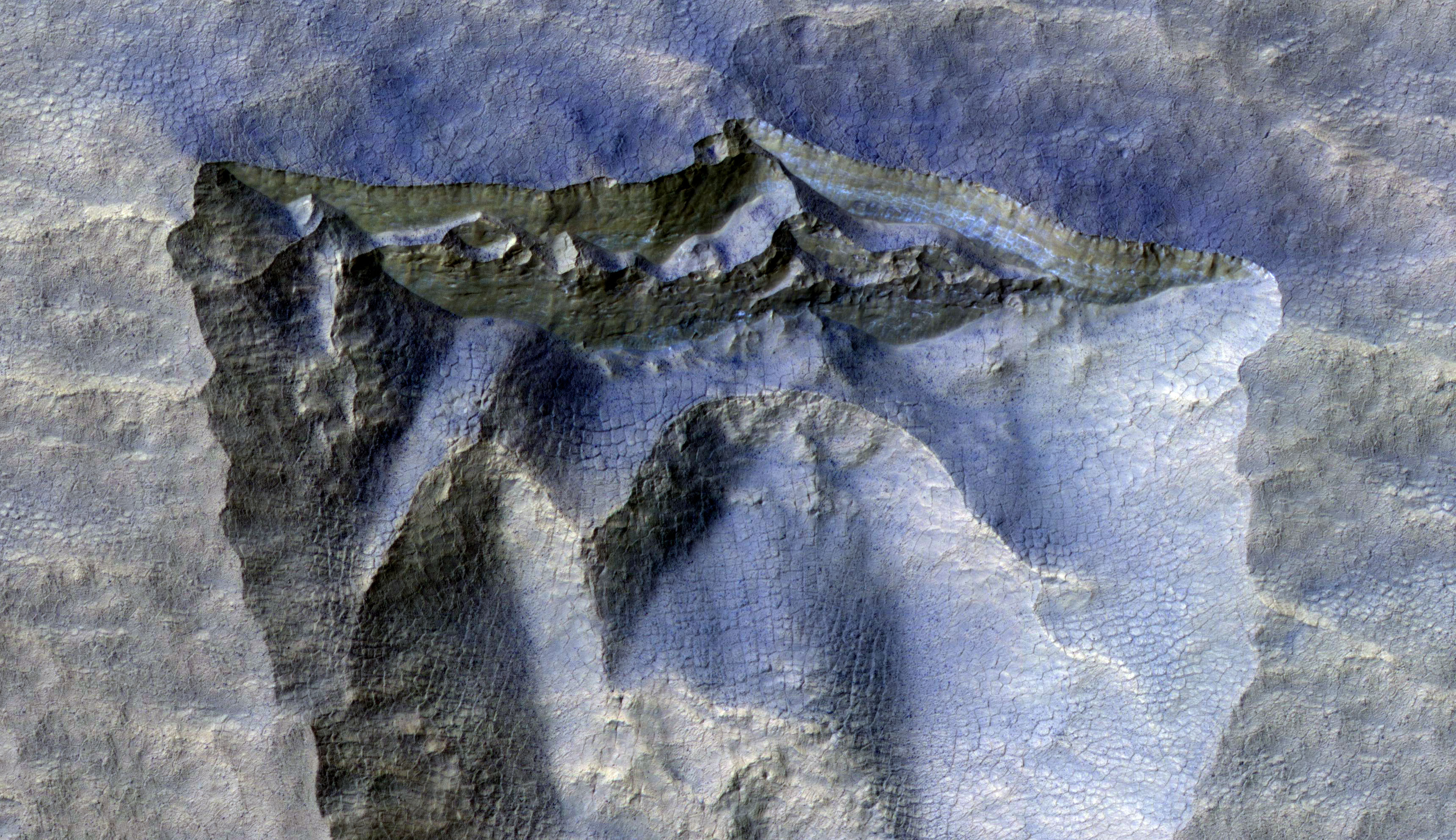
Today’s cool image to the right, cropped to post here, shows an ice scarp located in the high southern latitudes south of Hellas Basin. It was taken on August 15, 2020 by the high resolution camera on Mars Reconnaissance Orbiter (MRO), and was released today as a captioned image. From the caption:
Scientists have come to realize that, just below the surface, about one third of Mars is covered in ice. We study this ice to learn about Mars’ ancient climate and astronauts’ future water supplies.
Sometimes we see the buried ice because cliffs form like the one in this image. On the brownish, dusty cliff wall, the faint light-blue-colored ice shows through. [emphasis mine]
This ice scarp is one of about two dozen [pdf] that have so far been found within the latitude bands of approximately 45 to 65 degrees latitude in both the north and south hemispheres. The data so far obtained suggests that the scarp exists because of a pure water ice layer just below the surface. Over time this pole-facing cliff retreats away from the pole towards the equator, leaving behind it an extended pit. In the cliff wall scientists think they have detected evidence of that water ice layer.
Blue in MRO hi-res images can indicate both water as well as very rough surfaces. While much of the blue here could be ether, the blocky cracks suggest it is ice. As explained by Colin Dundas of the U.S. Geological Survey’s Astrogeology Science Center in Arizona and lead author of the pdf above,
The crack patterns are likely thermal contraction cracks, which form in shallowly buried ice due to seasonal temperature changes causing it to expand and contract. When that repeats over many years it creates regular patterns of cracks that organize themselves into polygons.
The overview image below gives the location of all known such scarps, as of March of 2020, taken from the pdf paper that I linked to above.
» Read more
Click for full image.
Today’s cool image to the right, cropped to post here, shows an ice scarp located in the high southern latitudes south of Hellas Basin. It was taken on August 15, 2020 by the high resolution camera on Mars Reconnaissance Orbiter (MRO), and was released today as a captioned image. From the caption:
Scientists have come to realize that, just below the surface, about one third of Mars is covered in ice. We study this ice to learn about Mars’ ancient climate and astronauts’ future water supplies.
Sometimes we see the buried ice because cliffs form like the one in this image. On the brownish, dusty cliff wall, the faint light-blue-colored ice shows through. [emphasis mine]
This ice scarp is one of about two dozen [pdf] that have so far been found within the latitude bands of approximately 45 to 65 degrees latitude in both the north and south hemispheres. The data so far obtained suggests that the scarp exists because of a pure water ice layer just below the surface. Over time this pole-facing cliff retreats away from the pole towards the equator, leaving behind it an extended pit. In the cliff wall scientists think they have detected evidence of that water ice layer.
Blue in MRO hi-res images can indicate both water as well as very rough surfaces. While much of the blue here could be ether, the blocky cracks suggest it is ice. As explained by Colin Dundas of the U.S. Geological Survey’s Astrogeology Science Center in Arizona and lead author of the pdf above,
The crack patterns are likely thermal contraction cracks, which form in shallowly buried ice due to seasonal temperature changes causing it to expand and contract. When that repeats over many years it creates regular patterns of cracks that organize themselves into polygons.
The overview image below gives the location of all known such scarps, as of March of 2020, taken from the pdf paper that I linked to above.
» Read more

