Reaching the summit of K2
An evening pause: Climbing those last few hundred feet and reaching the summit of K2, the world’s second highest mountain.
An evening pause: This zip line is clearly not as long a ride as this one, but who cares? And the finish is faster.
The view of Comet Lovejoy from ISS. With video.
An evening pause: Time lapse photography by Mark “Indy” Kochte. At one point the time-lapse sequence shows Seneca Rocks near the end of the day, with the lights of the climbers visible as they rappel off the mountain.
Who says it was tougher in the old days? Four times a year eighty Chinese children walk two days to school by traversing 1000 ft cliffs and fording swollen rivers.
The most dangerous part of the route is a path, which narrows to just a few inches wide, that has been cut into a cliff face some 1,000ft above the valley beneath. Without safety harnesses, the teachers gingerly shepherd their charges along. Further along, there are four freezing rivers to wade across, a 600ft-long zip-line to slide down, and bridges that are just a single plank wide. Teachers often carry the younger children on their backs, but some have fallen in the rivers in the past, without serious injury.
An evening pause: In China they are building a tourist footpath on the side of Shifou Mountain. For additional information as well as video of the work, go here.
A plank path along cliffs is taking shape in a scenic spot in Yuyang city, South China’s Hunan Province. The path zigzags several hundred meters long but is only one meter wide along cliffs, without guardrail. The path builders walk on it as if in an ordinary street.
A random collection of awesome things. In pictures.
An evening pause: Taking a walk through the Wave in the Paria Vanyon Vermillion Cliffs Wilderness Area, Arizona.
An evening pause: A hike to Romero Pools in the Santa Catalina Mountains just outside Tucson, Arizona. The hiker in the video calls this one of the toughest hikes he’s ever done, but it is only 5.6 miles round trip, with only a thousand foot elevation gain. Compared to most of the other Santa Catalina hikes, which routinely require elevation gains of 3000 to 5000 feet, this one is easy.
An evening pause: From the youtube webpage:
This inclined shaft is located outside of Searchlight, NV. The shaft itself is about 350 feet deep with two extensive drift levels along its length. We found a winze [a vertical shaft] in the lowest drift level that went down to what appeared to be an additional level.
I must emphasize that mines are very dangerous, and should be approached with great care and caution. Unlike a cave, which has had eons to slowly establish its stable structure, a mine is cut into the rock instantly (compared to geological time), and is thus very unstable and prone to collapse.
The ten most wonderful canyons in the world. With pictures.
These canyons are beautiful, but I am baffled that the list excludes the Grand Canyon, even though they repeatedly compare these ten canyons to it.
An evening pause: The rope work makes me cringe and some of the narration is a bit over the top, but the camerawork is superb, giving you a real feel of what it is like to visit this unique place.
Going to see the shuttle launch on Friday? The Space Walk of Fame Foundation Museum in Titusville, Florida needs volunteers to help organize the launch viewing at places like Space View Park.
A photo tour of Launch Complex 37B, level by level.
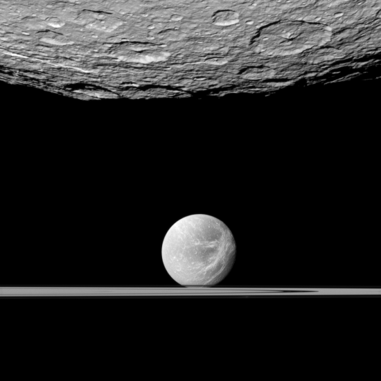
The image below was taken on January 11, 2011 by the space probe Cassini, in orbit around Saturn. First we see the southern polar regions of the moon Rhea, 949 miles in diameter. Beyond is the moon Dione, 698 miles across, appearing to sit on the rings of Saturn.
As far as I am concerned, this image, as well as almost every other image from Cassini, proves that any hotel built in orbit around Saturn is unquestionably going to be one of the hottest tourist spots in the solar system.
A rocket launch tonight at Wallops Island will be visible to most of the mid-Atlantic eastern United States.
Twelve of the world’s most beautiful lakes.
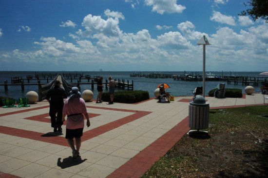
We have now set up at Space View Park in Titusville, Florida. The picture below shows what we found when we went by earlier today to scout out the location. As you can see, several people were already there. There were also people who had put up tents, as well as two food vendors.
The launchpad is the tiny spike visible on the horizon directly at the end of the pier. You can also see the VAB to the right.
As I write this I am sitting in the back seat of Bob & Brenda Rose’s minivan as we drive down to Florida for Monday’s shuttle launch. We plan to arrive at Space View Park in Titusville around 8 pm Sunday to claim a good location for seating, waiting, and watching the launch. We will be about 11 miles away, but this park is considered one of the better locations for the general public, with a clear view of the launchpad.
Stay tuned for more updates!
In Turkey: A hotel carved out of a mountain.