
Twenty places that you should try to visit before you die.
Twenty places that you should try to visit before you die.
Twenty places that you should try to visit before you die.
An evening pause:
An ode to the beauty of nature in 23 images.
An evening pause:
Eight strange rock islets from around the world.
An evening pause: This is something every visitor to New York should try to do. The first time I did it was back in the mid-1970s during my college days. It was around 2 am in the morning when we started from Brooklyn. We crossed to Manhattan, had a meal at a 24 hour Chinese restaurant in Chinatown, then walked back, watching the sunrise over Brooklyn.
Fifteen picturesque shipwrecks from around the world.
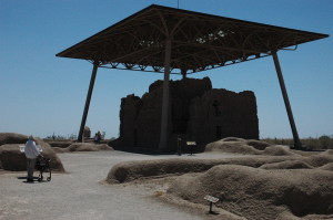
Yesterday my wife Diane and I took my 94-year-old mother on a sightseeing trip to see the Casa Grande ruins southeast of Phoenix, “the largest known structure left of the Ancestral People of the Sonoran Desert.”
This four story high structure was built around 1350 AD from bricks made of concrete-like caliche mud, with the floors and roofs supported by beams of pine, fir, and juniper brought from as far away as fifty miles. (The rooflike structure above the ruins was built by the National Park Service in order to protect it from rain.)
Though impressive, I must admit I’ve seen far more impressive American Indian ruins elsewhere. Casa Grande, which means “Great House” in Spanish, suffered as a tourist attraction from two faults:
» Read more
Set your calendar: The first solar eclipse to cross the continental United States in two decades will occur on May 20.
An annular solar eclipse occurs when the moon passes between the earth and sun, but the lunar disk does not completely block out the sun and instead leaves a “ring of fire” visible around the moon at the point of maximum eclipse. Most anyone west of the Mississippi will see a partial eclipse, but the real treat will be for those located in the 200-mile wide path of the eclipse which will trek east from the California / Oregon border through Nevada, Utah, Arizona, New Mexico, and finally set below the horizon in west Texas.
Remember, you will need good eye protection if you choose to look.
The twenty-five coolest garages in the world.
Any society that can still afford this is not yet completely doomed.
An underground military bunker, all your own!
Eleven ancient buildings built on a cliff’s edge.
The world’s eight most unique paths. With pictures.
Ten amazing treetop walkways from around the world.
Want to go hiking? You can now hike some of the country’s best trails, from the comfort of your home!
The five most spectacular spots on Earth that want to murder you.
Nine incredible places on Earth. With pictures.
Twenty pictures to help you appreciate the beauty and awesomeness of nature.
Nine unique and unusual travel destinations.
The universe is a strange and wonderful place. Go out and see it.