A glacial lake on Mars?
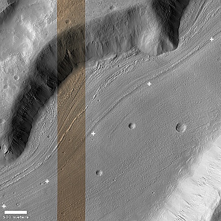
Cool image time! The picture to the right, rotated, cropped, reduced, and sharpened to post here, was taken on August 30, 2023 by the high resolution camera on Mars Reconnaissance Orbiter (MRO).
It shows what appears to be a glacial flow of ice, flowing downhill to the southwest and inside a wide canyon about three miles across. The canyon rims to the north and south are about 2,000 to 2,100 feet above the canyon’s lowest point, indicated by the string of “+” signs.
This close-up view immediately suggests a canyon whose glacier flows outward to the southwest into open lowland terrain, though the three craters, because they are undistorted, suggests that this flow is presently not active. That suggestion however would be wrong. It is always necessary to understand Martian geology to not only take close-in views at high resolution, but to zoom back and see the terrain in context.

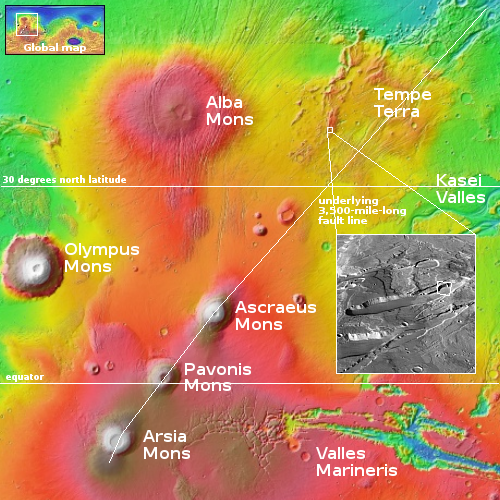
The white rectangle inside the inset on the overview map to the right marks the location of the photo above. If you look closely at the inset, an oblique view created from a global mosaic of MRO context camera images, you will see that this glacial flow is inside an enclosed 25-mile-long depression, with no outlet. According to MRO’s elevation data, the low point is not to the southwest, but in the center of the depression, with the flows going downhill from each end.
This depression thus is likely a graben, formed by the shifting of the ground along fault lines. In this case that shift likely produced a void as the ground was forced to spread apart by the bulging upward of this volcanic terrain. Because it is at 38 degrees north latitude, in the mid-latitude regions where orbital data sees numerous glacial features, it is not surprising that the floor of this depression appears filled with ice.
The feature however does pose one really intriguing question. If when active the ice has flown downhill from the depression’s ends, where does it go when it gets to the center? There is no pile-up there of glacial material. Is there an underground unseen drainage at that center point? Or does the ice sublimate away (during one part of the climate cycle) at a rate that matches the growth rate (during another part of the climate cycle)?
Your guess is as good as mine.
On Christmas Eve 1968 three Americans became the first humans to visit another world. What they did to celebrate was unexpected and profound, and will be remembered throughout all human history. Genesis: the Story of Apollo 8, Robert Zimmerman's classic history of humanity's first journey to another world, tells that story, and it is now available as both an ebook and an audiobook, both with a foreword by Valerie Anders and a new introduction by Robert Zimmerman.
The print edition can be purchased at Amazon or from any other book seller. If you want an autographed copy the price is $60 for the hardback and $45 for the paperback, plus $8 shipping for each. Go here for purchasing details. The ebook is available everywhere for $5.99 (before discount) at amazon, or direct from my ebook publisher, ebookit. If you buy it from ebookit you don't support the big tech companies and the author gets a bigger cut much sooner.
The audiobook is also available at all these vendors, and is also free with a 30-day trial membership to Audible.
"Not simply about one mission, [Genesis] is also the history of America's quest for the moon... Zimmerman has done a masterful job of tying disparate events together into a solid account of one of America's greatest human triumphs."--San Antonio Express-News
Cool image time! The picture to the right, rotated, cropped, reduced, and sharpened to post here, was taken on August 30, 2023 by the high resolution camera on Mars Reconnaissance Orbiter (MRO).
It shows what appears to be a glacial flow of ice, flowing downhill to the southwest and inside a wide canyon about three miles across. The canyon rims to the north and south are about 2,000 to 2,100 feet above the canyon’s lowest point, indicated by the string of “+” signs.
This close-up view immediately suggests a canyon whose glacier flows outward to the southwest into open lowland terrain, though the three craters, because they are undistorted, suggests that this flow is presently not active. That suggestion however would be wrong. It is always necessary to understand Martian geology to not only take close-in views at high resolution, but to zoom back and see the terrain in context.

The white rectangle inside the inset on the overview map to the right marks the location of the photo above. If you look closely at the inset, an oblique view created from a global mosaic of MRO context camera images, you will see that this glacial flow is inside an enclosed 25-mile-long depression, with no outlet. According to MRO’s elevation data, the low point is not to the southwest, but in the center of the depression, with the flows going downhill from each end.
This depression thus is likely a graben, formed by the shifting of the ground along fault lines. In this case that shift likely produced a void as the ground was forced to spread apart by the bulging upward of this volcanic terrain. Because it is at 38 degrees north latitude, in the mid-latitude regions where orbital data sees numerous glacial features, it is not surprising that the floor of this depression appears filled with ice.
The feature however does pose one really intriguing question. If when active the ice has flown downhill from the depression’s ends, where does it go when it gets to the center? There is no pile-up there of glacial material. Is there an underground unseen drainage at that center point? Or does the ice sublimate away (during one part of the climate cycle) at a rate that matches the growth rate (during another part of the climate cycle)?
Your guess is as good as mine.
On Christmas Eve 1968 three Americans became the first humans to visit another world. What they did to celebrate was unexpected and profound, and will be remembered throughout all human history. Genesis: the Story of Apollo 8, Robert Zimmerman's classic history of humanity's first journey to another world, tells that story, and it is now available as both an ebook and an audiobook, both with a foreword by Valerie Anders and a new introduction by Robert Zimmerman.
The print edition can be purchased at Amazon or from any other book seller. If you want an autographed copy the price is $60 for the hardback and $45 for the paperback, plus $8 shipping for each. Go here for purchasing details. The ebook is available everywhere for $5.99 (before discount) at amazon, or direct from my ebook publisher, ebookit. If you buy it from ebookit you don't support the big tech companies and the author gets a bigger cut much sooner.
The audiobook is also available at all these vendors, and is also free with a 30-day trial membership to Audible.
"Not simply about one mission, [Genesis] is also the history of America's quest for the moon... Zimmerman has done a masterful job of tying disparate events together into a solid account of one of America's greatest human triumphs."--San Antonio Express-News


Following the flow lines in the flat lake bottom, it appears the cliff/hillside extends over the flow lines but does not appear to be collapsed onto it. If the protruding hill was their first, the flow lines would go around it… Not under or through it. Obviously there’s more to this then what we can see.