Zebra layering in the Martian high southern latitudes
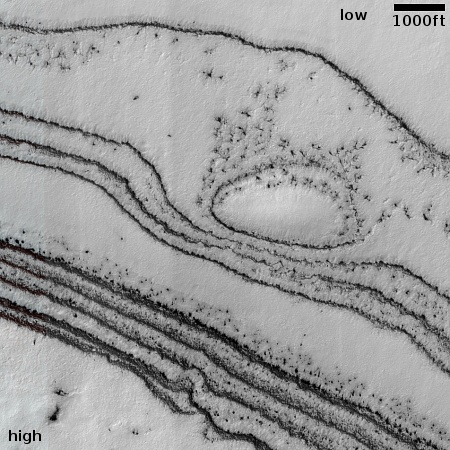
Cool image time! The picture to the right, rotated, cropped, reduced, and sharpened to post here, was taken on May 16, 2024 by the high resolution camera on Mars Reconnaissance Orbiter (MRO). The science team labeled it simple as a “terrain sample,” which usually indicates a picture not taken as part of any specific request or research project, but to fill a gap in the photography schedule in order to maintain the camera’s proper temperature.
When such pictures are necessary, the camera team tries to target the most interesting features that will be below MRO during the required time period. In this case they aimed for a north-facing slope, about 340 feet high, made up of a series of terraced layers, distinguished by the sharply contrasting bright flat benches and very dark cliff-faces.
While the cliffs are dark partly because of the sun is coming from the west, putting them in shadow, it is not entirely the cause. Note how the cliffs on the west side of the mound are also dark, suggesting that the darkness is a fundamental feature of the ground itself.

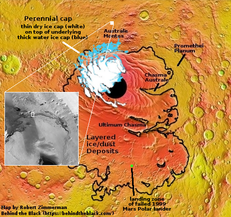
The white dot on the overview map to the right marks the location, about 400 miles north from Mars’ south pole. While this location is not considered part of the south polar ice cap, the terraced slope does appear to mark the edge of a layered ice/dust plateau, similar to other such plateaus that surround the ice cap, with Promethai Planum the most well known. In the inset you can see that this plateau extends to the south with no obvious end. In wider views it appears to connect to the ice cap directly.
As I noted in 2020,
For some reason Promethei Planum is not considered to be part of the layered ice/dust deposits that comprise most of the southern ice cap. Yet, this plateau clearly has layers, as shown in the image above, is made up of ice, as the Mars Express data suggests, and is covered with dust and debris. Why it is excluded from that layered ice/dust cap is not evident to me.
One could ask the same question about today’s cool image. Since this picture was taken in the spring, the white surfaces are likely water ice covered by the thin mantle of clear dry ice that covers everything above 60 degrees latitude during the winter, and then sublimates away with the coming of spring. This location is at 79 degrees south, and so the dry ice mantle is thus probably just beginning to disappear here, and many of the dark spots are likely places where it has done so. The darkness of the cliffs also suggests that the mantle sublimates away first at these steep locations.
On Christmas Eve 1968 three Americans became the first humans to visit another world. What they did to celebrate was unexpected and profound, and will be remembered throughout all human history. Genesis: the Story of Apollo 8, Robert Zimmerman's classic history of humanity's first journey to another world, tells that story, and it is now available as both an ebook and an audiobook, both with a foreword by Valerie Anders and a new introduction by Robert Zimmerman.
The print edition can be purchased at Amazon or from any other book seller. If you want an autographed copy the price is $60 for the hardback and $45 for the paperback, plus $8 shipping for each. Go here for purchasing details. The ebook is available everywhere for $5.99 (before discount) at amazon, or direct from my ebook publisher, ebookit. If you buy it from ebookit you don't support the big tech companies and the author gets a bigger cut much sooner.
The audiobook is also available at all these vendors, and is also free with a 30-day trial membership to Audible.
"Not simply about one mission, [Genesis] is also the history of America's quest for the moon... Zimmerman has done a masterful job of tying disparate events together into a solid account of one of America's greatest human triumphs."--San Antonio Express-News
Cool image time! The picture to the right, rotated, cropped, reduced, and sharpened to post here, was taken on May 16, 2024 by the high resolution camera on Mars Reconnaissance Orbiter (MRO). The science team labeled it simple as a “terrain sample,” which usually indicates a picture not taken as part of any specific request or research project, but to fill a gap in the photography schedule in order to maintain the camera’s proper temperature.
When such pictures are necessary, the camera team tries to target the most interesting features that will be below MRO during the required time period. In this case they aimed for a north-facing slope, about 340 feet high, made up of a series of terraced layers, distinguished by the sharply contrasting bright flat benches and very dark cliff-faces.
While the cliffs are dark partly because of the sun is coming from the west, putting them in shadow, it is not entirely the cause. Note how the cliffs on the west side of the mound are also dark, suggesting that the darkness is a fundamental feature of the ground itself.

The white dot on the overview map to the right marks the location, about 400 miles north from Mars’ south pole. While this location is not considered part of the south polar ice cap, the terraced slope does appear to mark the edge of a layered ice/dust plateau, similar to other such plateaus that surround the ice cap, with Promethai Planum the most well known. In the inset you can see that this plateau extends to the south with no obvious end. In wider views it appears to connect to the ice cap directly.
As I noted in 2020,
For some reason Promethei Planum is not considered to be part of the layered ice/dust deposits that comprise most of the southern ice cap. Yet, this plateau clearly has layers, as shown in the image above, is made up of ice, as the Mars Express data suggests, and is covered with dust and debris. Why it is excluded from that layered ice/dust cap is not evident to me.
One could ask the same question about today’s cool image. Since this picture was taken in the spring, the white surfaces are likely water ice covered by the thin mantle of clear dry ice that covers everything above 60 degrees latitude during the winter, and then sublimates away with the coming of spring. This location is at 79 degrees south, and so the dry ice mantle is thus probably just beginning to disappear here, and many of the dark spots are likely places where it has done so. The darkness of the cliffs also suggests that the mantle sublimates away first at these steep locations.
On Christmas Eve 1968 three Americans became the first humans to visit another world. What they did to celebrate was unexpected and profound, and will be remembered throughout all human history. Genesis: the Story of Apollo 8, Robert Zimmerman's classic history of humanity's first journey to another world, tells that story, and it is now available as both an ebook and an audiobook, both with a foreword by Valerie Anders and a new introduction by Robert Zimmerman.
The print edition can be purchased at Amazon or from any other book seller. If you want an autographed copy the price is $60 for the hardback and $45 for the paperback, plus $8 shipping for each. Go here for purchasing details. The ebook is available everywhere for $5.99 (before discount) at amazon, or direct from my ebook publisher, ebookit. If you buy it from ebookit you don't support the big tech companies and the author gets a bigger cut much sooner.
The audiobook is also available at all these vendors, and is also free with a 30-day trial membership to Audible.
"Not simply about one mission, [Genesis] is also the history of America's quest for the moon... Zimmerman has done a masterful job of tying disparate events together into a solid account of one of America's greatest human triumphs."--San Antonio Express-News


