The mysterious chaos terrain of Mars
In one of my weekly posts last month (dated May 14th) delving into the May image release from Mars Reconnaissance Orbiter’s (MRO) high resolution camera, I featured an image of what planetary geologists have labeled chaos terrain, a hummocky chaotic terrain that has no real parallel on Earth but is found in many places on Mars.
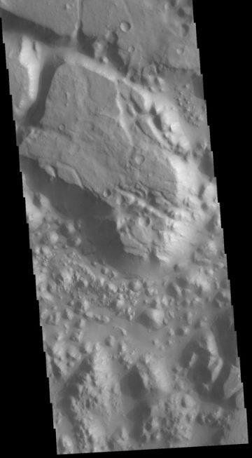
This month’s image MRO release included two more fascinating images of this type of terrain. In addition, the Mars Odyssey team today also released its own image of chaos terrain, showing a small part of a region dubbed Margaritifer Chaos. Below, the Mars Odyssey image is on the right, with one of the MRO images to the left. Both have been cropped, with the MRO image also reduced in resolution. The full MRO image shows what the MRO science team labels “possibly early stage chaos” on the rim of a canyon dubbed Shalbatana Vallis.


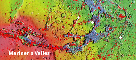
Both of these regions, as well as the chaos image featured in my May 14th post, are located in the outflow region from the solar system’s largest canyon, Marineris Valles. The overview map on the right shows their locations by the white crosses. Shalbatana Valles is the left cross, Margaritifer Chaos the right cross, and the center cross the location of my May 14th post.
Geologists believe that the random hummocky hills and mesas of chaos terrain were formed by erosion, as noted at the Mars Odyssey image site:
The term chaos is applied to regions where the surface is being eroded to form mesas. As the surface processes continue individual mesas become more isolated and take on the appearance of regions of hills. At the top of the image is Margaritifer Terra, which is being dissected into large mesas. Towards the bottom of the image the mesas have been eroded into smaller hills.
The MRO image above on the left seems to support this. This possibly young chaos appears to be eating away at the rim of Shalbatana Vallis, with mesas closer to the rim and hills farther away.
The location of so much chaos terrain at the mouth of Marineris Valles leads one to think that at least some if not most of this erosion was specifically caused by the sudden catastrophic outrush of liquid water that is believed to have formed Marineris Valles. Later erosion, as shown by the Shalbatana Vallis image above, might have come from the slow drainage of any remaining underground water-ice.

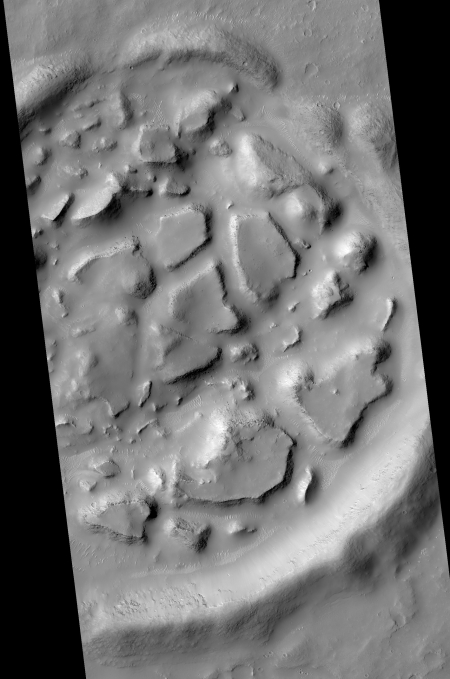
The problem is that chaos terrain is found in other places on Mars, and in places that do not really fit this scenario. The second MRO image of chaos terrain released this month, cropped and reduced in resolution and shown on the right, illustrates this. The chaos terrain fills the floor of this small crater. More importantly, the crater is surrounded by smooth plains, and is no where near any major outflow channels, or any other chaos terrain. Instead, this small patch of chaos is located to the southwest of Mars’s giant volcanoes, on the vast volcanic slopes heading downward towards the transition zone between Mars’s southern cratered highlands and the northern low plains.
The chaos terrain thus might not require a catastrophic outflow, as seen at the mouth of Marineris Valles. Instead, it might simply indicate a specific geological layer under the surface that is seen in many places on Mars, and becomes evident only with erosion. Or it could be a specific erosion feature formed due to the lower Martian gravity, which will lower the density of bedrock near the surface. Erosion will thus shape geology differently than on Earth.
Or it could form from many other erosion processes, some presently unknown. For example, why did chaos terrain only form inside this crater, and not on the plains that surround it?
It all remains a mystery, but a fundamental one for Mars. When we know more about chaos terrain, we will know more about the planet’s own inner geology.
On Christmas Eve 1968 three Americans became the first humans to visit another world. What they did to celebrate was unexpected and profound, and will be remembered throughout all human history. Genesis: the Story of Apollo 8, Robert Zimmerman's classic history of humanity's first journey to another world, tells that story, and it is now available as both an ebook and an audiobook, both with a foreword by Valerie Anders and a new introduction by Robert Zimmerman.
The print edition can be purchased at Amazon or from any other book seller. If you want an autographed copy the price is $60 for the hardback and $45 for the paperback, plus $8 shipping for each. Go here for purchasing details. The ebook is available everywhere for $5.99 (before discount) at amazon, or direct from my ebook publisher, ebookit. If you buy it from ebookit you don't support the big tech companies and the author gets a bigger cut much sooner.
The audiobook is also available at all these vendors, and is also free with a 30-day trial membership to Audible.
"Not simply about one mission, [Genesis] is also the history of America's quest for the moon... Zimmerman has done a masterful job of tying disparate events together into a solid account of one of America's greatest human triumphs."--San Antonio Express-News


That last one looks like an impactor hit a layer of lava that rebounded up, earlier than the surrounding impacts…
Check out the flow channels.
http://viewer.mars.asu.edu/planetview/inst/hirise/ESP_017251_2300_COLOR#P=ESP_017251_2300_COLOR&T=2
MarcusZ1967: Very cool image. Better to look at it here.
This however is unrelated to chaos terrain. These flow channels, on a hillside, are located in the vast northern plains, and appears to be avalanches or collapses as the hillside erodes.
Nonetheless, this is a great find. There are so many cool things hidden in the MRO high resolution camera archive I can’t possibly find them all. Thank you!
I should add that it appears the MRO science team has been monitoring these flows since 2010 to see if there were any changes. From my very cursory comparison between a 2010 and 2017 image I don’t see any obvious changes, but I don’t have much confidence in that conclusion. I would need to spend several hours looking at the high resolution versions to know for sure.
Those look like the scablands of Eastern Washington caused by the numerous “Great Lake Missoula Floods”. I just have to head ten minutes west of my house to see what Marineris Valles is like.