
Buried mountain on Mars
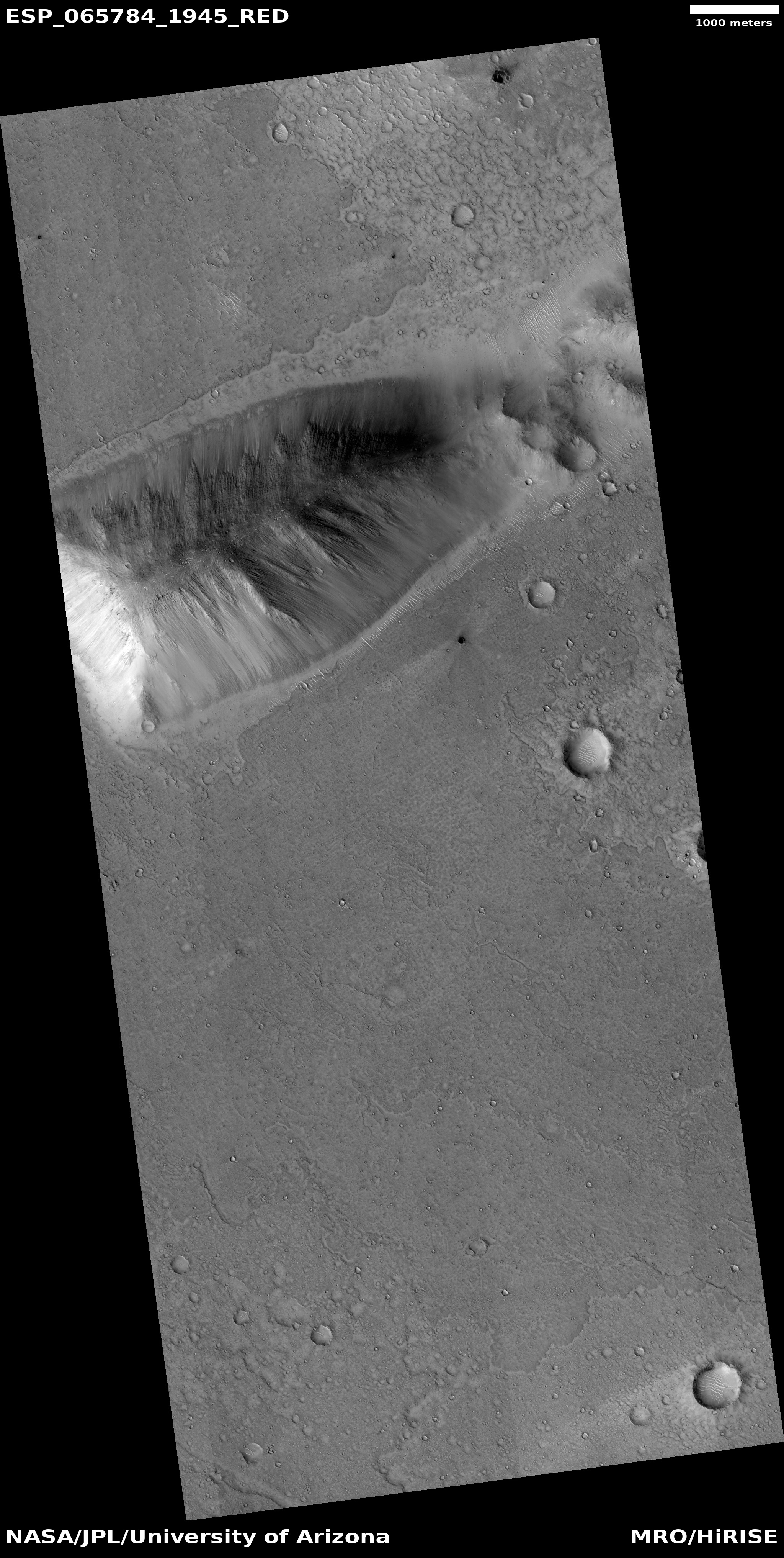
Click for full image.
Cool image time! The photo to the right, rotated, cropped, and reduced to post here, was taken on August 8, 2020 by the high resolution camera on Mars Reconnaissance Orbiter (MRO). Labeled merely as a “terrain sample,” it is an example of an image taken more for engineering than scientific reasons. No research scientist specifically requested it. Instead, the scientists operating the camera took it because they need to use MRO regularly to maintain the camera’s proper temperature. To do this they periodically take almost random images, but never without trying to pick a location that might have some scientific value.
In this case we get what appears to be an isolated sloping hill. Located at about 15 degrees north latitude, this is not a place where one would expect visible evidence of water, though the gullies on the slopes are intriguing. They almost look like the kind of hillside erosion you see in places where rain falls on desert mountainsides.
Rain can’t be the cause, but nonetheless monitoring these gullies for changes over time would be worthwhile science research. Since it appears no one is presently focused on doing it, anyone interested out there?
This mountain is actually far more isolated than this high resolution image suggests.

Click for full image.
The image to the right is a wide shot taken by the context camera on MRO. The hill in the first photo above is the bottom of the two in this picture. As you can see, these two hills stand out against a remarkably flat plain. If you look at the full image, you will see that this plain is even far larger, extending for many miles in all directions. The plain is also remarkably lacking in craters, which strongly suggests its surface is very young.
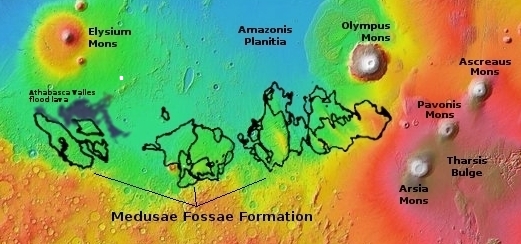
The map below provides I think the basic explanation. The hill’s location, as indicated by the white box, is about 650 miles to the southeast of the giant shield volcano Elysium Mons, and about 250 miles to the northeast from the lava outflow channel dubbed Athabasca Valles. The latter produced in a matter of only a few weeks a lava flood plain about the size of the British Isles, apparently flowing to the southwest away from this hill, as shown on the map.
The lack of craters suggests this hill is surrounded by a similar relatively young lava field, produced by an eruption from some as-yet unidentified nearby volcanic event. A close look at the features at the base of the hill’s slopes strongly suggests that the lava flow came from the west, flowing around the hill as it moved eastward.
The surrounding flood plain also suggests something quite fascinating. It suggests that these two hills are actually the peaks of much larger and older mountains, buried by the lava plain that now surrounds them.
How tall were these mountains when exposed? That is unknown. They likely come from the cratered Mars of the early solar system, during the Heavy Late Bombardment when the inner planets were being peppered by many impacts as the Sun’s debris disk was consolidating into the planets we see today.
Now, all these short hills do is hint at a very different ancient and hidden Mars, covered by the extensive Martian volcanism that engulfed the surface of this entire vast region.

On Christmas Eve 1968 three Americans became the first humans to visit another world. What they did to celebrate was unexpected and profound, and will be remembered throughout all human history. Genesis: the Story of Apollo 8, Robert Zimmerman's classic history of humanity's first journey to another world, tells that story, and it is now available as both an ebook and an audiobook, both with a foreword by Valerie Anders and a new introduction by Robert Zimmerman.
The print edition can be purchased at Amazon or from any other book seller. If you want an autographed copy the price is $60 for the hardback and $45 for the paperback, plus $8 shipping for each. Go here for purchasing details. The ebook is available everywhere for $5.99 (before discount) at amazon, or direct from my ebook publisher, ebookit. If you buy it from ebookit you don't support the big tech companies and the author gets a bigger cut much sooner.
The audiobook is also available at all these vendors, and is also free with a 30-day trial membership to Audible.
"Not simply about one mission, [Genesis] is also the history of America's quest for the moon... Zimmerman has done a masterful job of tying disparate events together into a solid account of one of America's greatest human triumphs."--San Antonio Express-News
A deep flow of material across the entire plane surrounding the peaks. Curious about the dark holes? are they windows? Impact craters have a rim around them. On the original picture, I count over 30 such black pits. There’s also streaking coming from the pits indicating outflow of gases. Just guessing…
Max: Good eye! I as going to discuss them but forgot. As such I did not research them at all, but based on past readings I think these dark craters or depressions are all thought to be vents, though why and what they are venting is entirely all unknown.
@Max, I think they are fresh impact craters too small to have the rims resolved in the image. There have been many photos of fresh Martian craters, and they all seem to have dark ejecta splashes.
It must have been some spectacular event which flooded the area with molten rock…. I would have loved to be a spectator, but from a good distance!!!
On a related note, the mountains seen relatively free from craters compared to the surrounding area, given that Bobs theory ( which I agree with ) indicates they are much older than the surrounding plains, this is pretty bizarre!
Lee: You could be correct in some cases, maybe all. However, the dark crater in the section I posted appears to have all its dark material inside the crater. This is not how fresh craters look.
On closer examination you guys are right, and I stand corrected. Although there is ejecta spreads from some of the dark spots, the majority do not have… The dark spot bottom right on the large view is especially interesting.
Some sort of residual volcanic activity under the lava plane venting? Who knows? This is definitely one of the most interesting “cool images” posted ( in my opinion ) , and to think it was not even a designated science target!
As you always remind us Bob… Mars is genuinely alien. The sooner we have boots on the ground to go and poke at these mysteries the better!
Mars has soft soil its quite plain that the soil of Mars is Soft like sand and a winds maybe
I wish there were 3D pictures of Martian terrain.
Edward_2: There ARE 3D pictures from Mars. MRO’s high resolution picture routinely takes two images of many of the cool images I feature for the purpose of creating a stereo image. I don’t post these because it involves far more time than I can afford, and the use of software I don’t know and don’t have the right computer for.
If you dug into the archive of the high resolution camera (here) you will find these images. The archive also will lead you to obtaining the software. If you or anyone wants to play around and produce something, I’d be glad to post it here.
Note that you can view many of these images as anaglyphs here.