Ice-filled canyon on Mars?
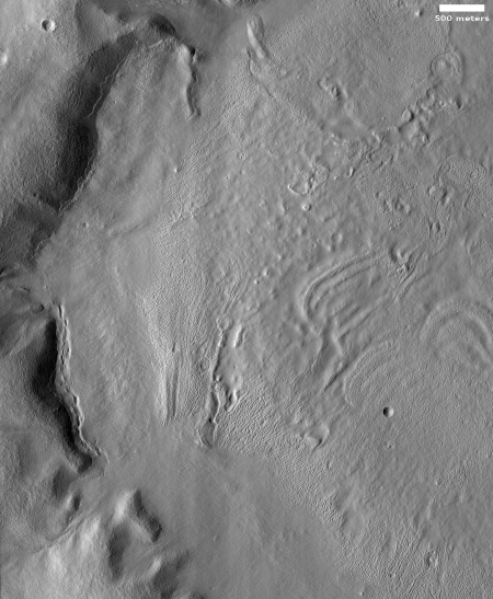
The image to the right, rotated, cropped and reduced to post here, was taken on December 19, 2019 by the high resolution camera on Mars Reconnaissance Orbiter (MRO). Labeled “Head of Mamers Valles”, it shows the very end of one side canyon to this very extensive canyon system made up of the fractured fissures and mesas of chaos terrain.
Mamers Valles itself sits in the transition zone between the northern lowland plains and the southern cratered highlands. This specific canyon is close to those lowlands, at a latitude of 40 degrees north, where scientists believe there are many buried inactive glaciers of ice.
The image reinforces this belief. The entire canyon appears practically filled with what looks like ice. In fact, it almost looks like we are looking down at a frozen lake with a layer of snow on top of it. In this case, the layer is not snow, but dust and dirt and debris that covers the ice to protect it and prevent it from sublimating away.
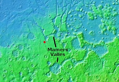
The overview map below shows the location of this canyon, by the red cross, within Mamers Valles.

Mamers Valles is actually a very large collection of miscellaneous canyons, flowing into the lowlands. In some areas it looks like very old chaos terrain, with the canyons so eroded that all we see are scattered mesas. In other places the canyons more resemble meandering river canyons sometimes interspersed with crater impacts.
Scientists have analyzed the canyons in Mamers Valles, and from this concluded that they were likely formed from “subsurface hydrologic activity”. which in plain English means that flowing water below ground washed out large underground passages, which eventually grew large enough for their ceilings to collapse and form the canyons we see today.
Yesterday I posted an image of a string of pits that could very well be evidence of this same process in its early stages of canyon formation. In Mamers Valles the process is far more advanced, and the canyons have existed for a long time, long enough for the planet’s inclination to go through several cycles of change, from a low of 25 degrees tilt (what it is now) to has high as 60 degrees. At that high inclination the mid-latitudes were colder than the poles, so that ice would sublimate from the poles to fall as snow in the mid-latitudes, forming active glaciers within canyons such as this.
Now that the planet’s inclination is similar to Earth’s, 25 degrees, the poles are slightly colder than the mid-latitudes, and the glaciers in this canyon are either inactive (if buried) or slowly sublimating away so that the water can return to the poles.
Here however the surface debris appears to be protecting the glaciers, leaving the canyon filled mostly with ice. For future settlers this ice would likely be relatively accessible, and at a latitude where the environment is also relatively mild, for Mars.
On Christmas Eve 1968 three Americans became the first humans to visit another world. What they did to celebrate was unexpected and profound, and will be remembered throughout all human history. Genesis: the Story of Apollo 8, Robert Zimmerman's classic history of humanity's first journey to another world, tells that story, and it is now available as both an ebook and an audiobook, both with a foreword by Valerie Anders and a new introduction by Robert Zimmerman.
The print edition can be purchased at Amazon or from any other book seller. If you want an autographed copy the price is $60 for the hardback and $45 for the paperback, plus $8 shipping for each. Go here for purchasing details. The ebook is available everywhere for $5.99 (before discount) at amazon, or direct from my ebook publisher, ebookit. If you buy it from ebookit you don't support the big tech companies and the author gets a bigger cut much sooner.
The audiobook is also available at all these vendors, and is also free with a 30-day trial membership to Audible.
"Not simply about one mission, [Genesis] is also the history of America's quest for the moon... Zimmerman has done a masterful job of tying disparate events together into a solid account of one of America's greatest human triumphs."--San Antonio Express-News
The image to the right, rotated, cropped and reduced to post here, was taken on December 19, 2019 by the high resolution camera on Mars Reconnaissance Orbiter (MRO). Labeled “Head of Mamers Valles”, it shows the very end of one side canyon to this very extensive canyon system made up of the fractured fissures and mesas of chaos terrain.
Mamers Valles itself sits in the transition zone between the northern lowland plains and the southern cratered highlands. This specific canyon is close to those lowlands, at a latitude of 40 degrees north, where scientists believe there are many buried inactive glaciers of ice.
The image reinforces this belief. The entire canyon appears practically filled with what looks like ice. In fact, it almost looks like we are looking down at a frozen lake with a layer of snow on top of it. In this case, the layer is not snow, but dust and dirt and debris that covers the ice to protect it and prevent it from sublimating away.
The overview map below shows the location of this canyon, by the red cross, within Mamers Valles.

Mamers Valles is actually a very large collection of miscellaneous canyons, flowing into the lowlands. In some areas it looks like very old chaos terrain, with the canyons so eroded that all we see are scattered mesas. In other places the canyons more resemble meandering river canyons sometimes interspersed with crater impacts.
Scientists have analyzed the canyons in Mamers Valles, and from this concluded that they were likely formed from “subsurface hydrologic activity”. which in plain English means that flowing water below ground washed out large underground passages, which eventually grew large enough for their ceilings to collapse and form the canyons we see today.
Yesterday I posted an image of a string of pits that could very well be evidence of this same process in its early stages of canyon formation. In Mamers Valles the process is far more advanced, and the canyons have existed for a long time, long enough for the planet’s inclination to go through several cycles of change, from a low of 25 degrees tilt (what it is now) to has high as 60 degrees. At that high inclination the mid-latitudes were colder than the poles, so that ice would sublimate from the poles to fall as snow in the mid-latitudes, forming active glaciers within canyons such as this.
Now that the planet’s inclination is similar to Earth’s, 25 degrees, the poles are slightly colder than the mid-latitudes, and the glaciers in this canyon are either inactive (if buried) or slowly sublimating away so that the water can return to the poles.
Here however the surface debris appears to be protecting the glaciers, leaving the canyon filled mostly with ice. For future settlers this ice would likely be relatively accessible, and at a latitude where the environment is also relatively mild, for Mars.
On Christmas Eve 1968 three Americans became the first humans to visit another world. What they did to celebrate was unexpected and profound, and will be remembered throughout all human history. Genesis: the Story of Apollo 8, Robert Zimmerman's classic history of humanity's first journey to another world, tells that story, and it is now available as both an ebook and an audiobook, both with a foreword by Valerie Anders and a new introduction by Robert Zimmerman.
The print edition can be purchased at Amazon or from any other book seller. If you want an autographed copy the price is $60 for the hardback and $45 for the paperback, plus $8 shipping for each. Go here for purchasing details. The ebook is available everywhere for $5.99 (before discount) at amazon, or direct from my ebook publisher, ebookit. If you buy it from ebookit you don't support the big tech companies and the author gets a bigger cut much sooner.
The audiobook is also available at all these vendors, and is also free with a 30-day trial membership to Audible.
"Not simply about one mission, [Genesis] is also the history of America's quest for the moon... Zimmerman has done a masterful job of tying disparate events together into a solid account of one of America's greatest human triumphs."--San Antonio Express-News


Bob, I see by your focus recently ( I know you have followed this topic for years, but your interest seems to have increased over the last year or so) , that you and I actually agree on something for a change… Namely that there is a high probability of all the “missing water” on Mars is hiding not too far below the surface.
We have discussed before the observation that many of the dark stripes on crater walls seem to originate from the same depth. My theory is that this is the “groundwater” strata. When Mars lost its atmosphere the surface water sublimed away… But I see no reason why aquifers would have been affected, other than by cold, and perhaps frozen in place.
These huge glacial flows you have been reporting on, if verified, could have a massive impact upon the chances for human colonization of Mars, and if any combination of pressure and perhaps extant volcanism, mean that liquid water exists, that life could still exist today.
We live in the most exciting time in the history of space exploration so far… I was in nappies when we left the moon for the last time… But I will take it, if we can confirm or deny life on our neighbor.
What think you?
Imaged in December of 2020? Do you happen to have stock market report or newspaper sports section to go with this? : )
MDN: Whoops. Thank you for spotting that typo. Now fixed.
Ok, sorry Bob… I know you rarely enter into conversation directly here on your blog, and you have not yet written any long form piece on this subject, so I guess I will just have to sit in anticipation.
Regardless, my theory is that the pressure from overlying rocks is enough to keep the water table stable
The location of all these glaciers, if confirmed, puts pay to my theory… And opens a whole tin of new ones.
We really need a lander that can report “boots on the ground” conditions… The book is still open on the Phoenix lander lander results..(water drops appearing on the legs?)
Mars is by definition “alien” and local, “normal” physics don’t apply….
I’m gagging at the bit to see some hard scientific results from boots, or qualified rover wheels on the ground!
Lee S wrote, “…you have not yet written any long form piece on this subject…”
I guess your definition of “long form” is different then mine, considering the number of 500 word to 2000 word posts I have put up on the subject of ice and glaciers on Mars. :)
Your theory about the overburden of debris on top of the ice acting to protect it is essentially correct. It appears that the Martian climate right now is tending to erode the mid-latitude glaciers to send the water back to the colder poles. If not covered by rocks and dust (which might be a very thin veneer), the ice in most of the mid-latitudes would have long since sublimated away. Still, it appears this sublimation is happening the farther south you go.
The glaciers however are not the only known water source we have found on Mars. Consider the ice scarps, which reveal a deeper layer of permanent ice that corresponds to a sedimentary layer. Such a layer could exist almost anywhere on Mars, since it is not part of the pole/mid-latitude atmospheric water cycle.