
Landslides on the edge of Mars’ youngest lava field
Click for full image.
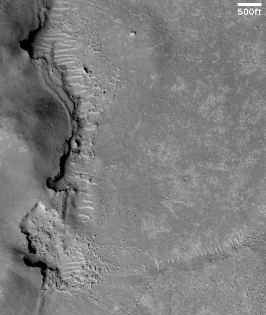
Cool image time! The photo to the right, cropped to post here, was taken by the high resolution camera on Mars Reconnaissance Orbiter (MRO) on September 28, 2020. It shows several indentations in a north-south cliff face, with debris apparently falling down into a flat plain to the east.
The scientific history of this picture is very interesting. The first photo of these landslides was taken in 2006 and was titled, “Landslides on Flat Topography in Elysium Planitia”. The second, taken a few months later in 2007 to produce a stereoscopic view, was labeled “Landslides Along Shoreline in Elysium Planitia.” This most recent 2020 image is merely labeled “Landslides in Elysium Planitia.”
Is the flat terrain to the west a seabed to an ancient ocean, as suggested by the title for the 2007 image, with these landslides erosion caused in the far past by water lapping up against these cliffs?
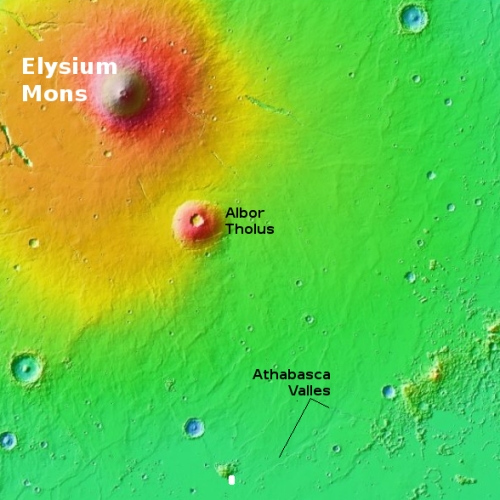
More recent research tells us no. The two overview maps to the right provides the explanation. The first shows the nearby important geology surrounding this photo, indicated by the white rectangle near the center bottom. The smaller shield volcano Albor Tholus is about 400 miles to the north. Much closer to the east however is Athabasca Valles, which some scientists believe [pdf] is the source for the youngest lava flood plain on Mars. Athabasca Valles is thought to have been active around 600 million years ago, during which it laid down a flood plain about the size of Great Britain in only a matter of weeks.
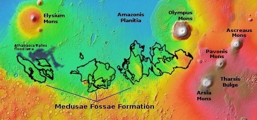
The second overview map takes a wider view, and shows the estimated extent of the Athabasca lava flood plain. That flow pushed up against the eastern flanks of this lonely mountain, pressing against the cliff where the landslides are shown in the above photo.
In comparing the 2020 image with the 2006 image I can find no obvious changes. At higher resolutions there certainly could be evidence of small landslides, but the general features appear the same.
Could these landslides date from 600 million years ago, when Athabasca Valles was active and emitting lava? I have no idea, but my guess is no. More likely the slides indicate subsequent erosion by wind and the seasonal temperature cycles causing breakage in the rocks over time.
What today’s cool image does show us is a real shoreline, but not of a lake or ocean but of a lava flood plain now frozen for more than a half billion years.

On Christmas Eve 1968 three Americans became the first humans to visit another world. What they did to celebrate was unexpected and profound, and will be remembered throughout all human history. Genesis: the Story of Apollo 8, Robert Zimmerman's classic history of humanity's first journey to another world, tells that story, and it is now available as both an ebook and an audiobook, both with a foreword by Valerie Anders and a new introduction by Robert Zimmerman.
The print edition can be purchased at Amazon or from any other book seller. If you want an autographed copy the price is $60 for the hardback and $45 for the paperback, plus $8 shipping for each. Go here for purchasing details. The ebook is available everywhere for $5.99 (before discount) at amazon, or direct from my ebook publisher, ebookit. If you buy it from ebookit you don't support the big tech companies and the author gets a bigger cut much sooner.
The audiobook is also available at all these vendors, and is also free with a 30-day trial membership to Audible.
"Not simply about one mission, [Genesis] is also the history of America's quest for the moon... Zimmerman has done a masterful job of tying disparate events together into a solid account of one of America's greatest human triumphs."--San Antonio Express-News
Click for full image.
Cool image time! The photo to the right, cropped to post here, was taken by the high resolution camera on Mars Reconnaissance Orbiter (MRO) on September 28, 2020. It shows several indentations in a north-south cliff face, with debris apparently falling down into a flat plain to the east.
The scientific history of this picture is very interesting. The first photo of these landslides was taken in 2006 and was titled, “Landslides on Flat Topography in Elysium Planitia”. The second, taken a few months later in 2007 to produce a stereoscopic view, was labeled “Landslides Along Shoreline in Elysium Planitia.” This most recent 2020 image is merely labeled “Landslides in Elysium Planitia.”
Is the flat terrain to the west a seabed to an ancient ocean, as suggested by the title for the 2007 image, with these landslides erosion caused in the far past by water lapping up against these cliffs?
More recent research tells us no. The two overview maps to the right provides the explanation. The first shows the nearby important geology surrounding this photo, indicated by the white rectangle near the center bottom. The smaller shield volcano Albor Tholus is about 400 miles to the north. Much closer to the east however is Athabasca Valles, which some scientists believe [pdf] is the source for the youngest lava flood plain on Mars. Athabasca Valles is thought to have been active around 600 million years ago, during which it laid down a flood plain about the size of Great Britain in only a matter of weeks.
The second overview map takes a wider view, and shows the estimated extent of the Athabasca lava flood plain. That flow pushed up against the eastern flanks of this lonely mountain, pressing against the cliff where the landslides are shown in the above photo.
In comparing the 2020 image with the 2006 image I can find no obvious changes. At higher resolutions there certainly could be evidence of small landslides, but the general features appear the same.
Could these landslides date from 600 million years ago, when Athabasca Valles was active and emitting lava? I have no idea, but my guess is no. More likely the slides indicate subsequent erosion by wind and the seasonal temperature cycles causing breakage in the rocks over time.
What today’s cool image does show us is a real shoreline, but not of a lake or ocean but of a lava flood plain now frozen for more than a half billion years.
On Christmas Eve 1968 three Americans became the first humans to visit another world. What they did to celebrate was unexpected and profound, and will be remembered throughout all human history. Genesis: the Story of Apollo 8, Robert Zimmerman's classic history of humanity's first journey to another world, tells that story, and it is now available as both an ebook and an audiobook, both with a foreword by Valerie Anders and a new introduction by Robert Zimmerman.
The print edition can be purchased at Amazon or from any other book seller. If you want an autographed copy the price is $60 for the hardback and $45 for the paperback, plus $8 shipping for each. Go here for purchasing details. The ebook is available everywhere for $5.99 (before discount) at amazon, or direct from my ebook publisher, ebookit. If you buy it from ebookit you don't support the big tech companies and the author gets a bigger cut much sooner.
The audiobook is also available at all these vendors, and is also free with a 30-day trial membership to Audible.
"Not simply about one mission, [Genesis] is also the history of America's quest for the moon... Zimmerman has done a masterful job of tying disparate events together into a solid account of one of America's greatest human triumphs."--San Antonio Express-News
“… a lava flood plain now frozen for more than a half million years.”
Typo alert: More than half a billion years, of course.
Michael McNeil: Thank you. Fixed. As I say, what would I do without my readers.