
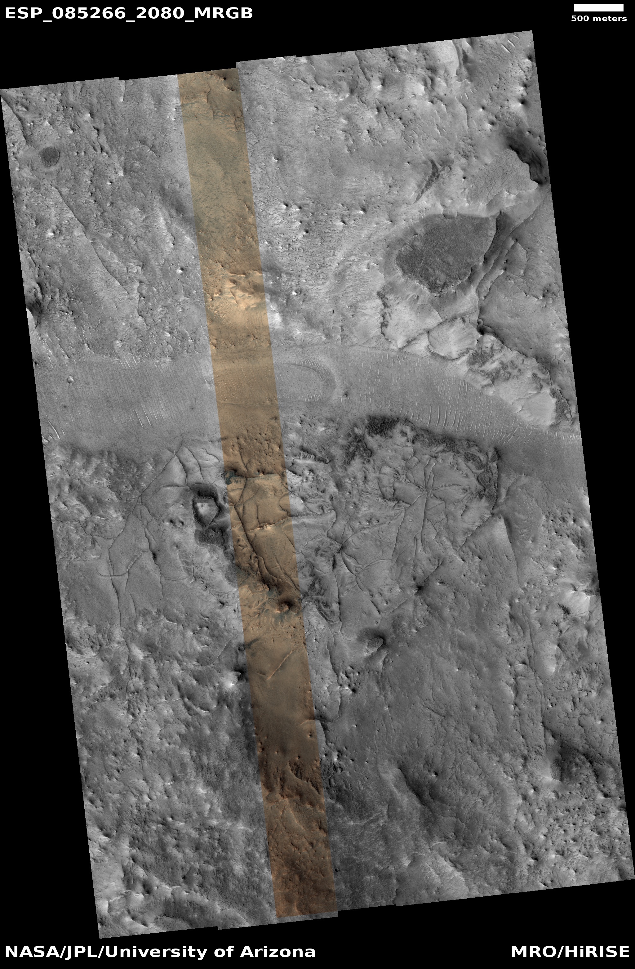
Ridges from fractures at the head of a 300+mile-long Martian drainage channel
Click for original image.
Cool image time! The picture to the right, cropped, reduced, and sharpened to post here, was taken on October 4, 2024 by the high resolution camera on Mars Reconnaissance Orbiter (MRO).
The science team labels this “Exhumed Fracture Network,” referring to the criss-crossing ridges on the eroded mesa at the picture’s center. That mesa only rises about sixty feet from the east-west channel at the top of the picture, but the location is actually on the outside northern rim of an unnamed 70-mile-wide very eroded ancient crater. The rim itself rises another 500 feet to the south before descending 10,000 feet to the crater floor.
I am assuming by the title that the geologists believe this ridges were originally cracks that got filled with more resistant material, probably lava. The fracture network then got covered over. More recent erosion removed the material around the cracks, but the material in the cracks resisted that erosion.
The most intriguing feature in this picture however might actually be that nondescript channel.
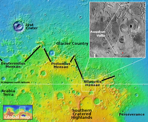
The red dot on the overview map to the right marks the location of the picture, south of the heavily glaciated chaos region called Nilosyrtis Mensae. This location is also in the dry equatorial regions, at about 28 degrees north latitude, so we should not expect to find much near surface ice.
The channel in the picture is actually the source of the 300-plus-mile-long Auqakun Vallis, one of the many ancient meandering canyons on Mars that make every Earthman who sees them assume water once flowed on Mars. That might be true, but so far the data is inconclusive. If anything, that data is beginning to suggest, but also not confirmed, that the flows were glacial ice, not liquid water.
Either way, Auqakun Vallis drops about 55,000 feet over those 300 miles, where it drains into the northern lowland plains at a point where a lot of glaciers are found. Moreover, along the way it enters the mid-latitudes, where near surface ice is often found. In doing a quick review of the relatively few MRO high resolution images of this canyon along its route, it does not appear there are glacial features within it at any point, but these could exist in the north, buried by sand and dust.

On Christmas Eve 1968 three Americans became the first humans to visit another world. What they did to celebrate was unexpected and profound, and will be remembered throughout all human history. Genesis: the Story of Apollo 8, Robert Zimmerman's classic history of humanity's first journey to another world, tells that story, and it is now available as both an ebook and an audiobook, both with a foreword by Valerie Anders and a new introduction by Robert Zimmerman.
The print edition can be purchased at Amazon or from any other book seller. If you want an autographed copy the price is $60 for the hardback and $45 for the paperback, plus $8 shipping for each. Go here for purchasing details. The ebook is available everywhere for $5.99 (before discount) at amazon, or direct from my ebook publisher, ebookit. If you buy it from ebookit you don't support the big tech companies and the author gets a bigger cut much sooner.
The audiobook is also available at all these vendors, and is also free with a 30-day trial membership to Audible.
"Not simply about one mission, [Genesis] is also the history of America's quest for the moon... Zimmerman has done a masterful job of tying disparate events together into a solid account of one of America's greatest human triumphs."--San Antonio Express-News
Minor edits in second paragraph:
“That mesa only rises about sixty feet from the east-west channel”
“The rim itself rises another 500 feet to the south before descending 10,000 feet to the the crater floor.”
Andi: Fixed. Thank you.
Amazing! I’m still a little miffed you went Electric at Newport, Bob
Sandy V: I am intrigued, having never been to Newport. What are you referring to? Please explain.
Dylan at Newport (1965)
https://youtu.be/a6Kv0vF41Bc
(6:12)
Foghorn Leghorn
“That’s a Joke, Boy”
https://youtu.be/EVAdt5bH2tE
(0:32)
wayne: I get it now. It just ain’t that good a joke. Too obscure.