
Two pits at opposite ends of Mars’ big volcanoes
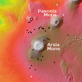
Regular readers of Behind the Black know that since 2018 I have regularly documented all the images of pits taken by the high resolution camera on Mars Reconnaissance Orbiter (MRO). (See my last pit post in January for a full list of these previous articles.) The black dots on the map to the right shows the location of all the pits near the volcanoes Arsia and Pavonis Mons that have so far been highlighted here.
The two white dots are the two most recent MRO pits, and are the subject of today’s cool image. They also happen to be the farthest north and south pits so far documented. The southernmost pit, which I am saving till last, is the most interesting.
Click for full image.
Click for full image.
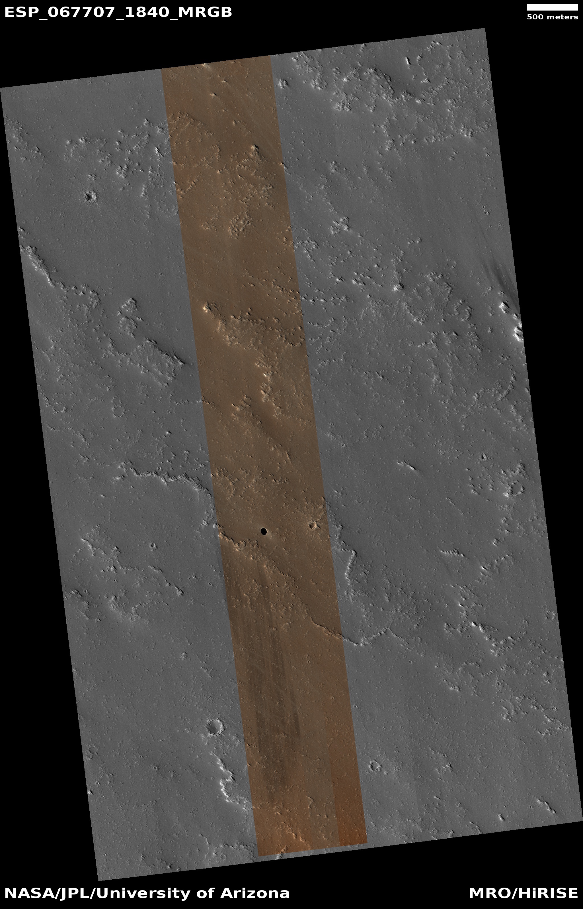
The first pit to the right, the image cropped to post here, was taken on January 5, 2021. It is located to the northeast of Pavonis Mons, and is similar to most of these likely skylights into an underground lava tube. When compared to the nearby similarly-sized impact crater to the east, the differences are obvious. The pit’s edges are sharp, with no rim as you’d see with a crater. It is also much deeper than a crater, with the strong suggestion that the pit’s edges are overhung. While we cannot see for sure whether there are any underlying passages leading off from this pit, there is a faint hint on the surface of a northwest-to-southwest depression under this pit, suggesting the lava tube itself.
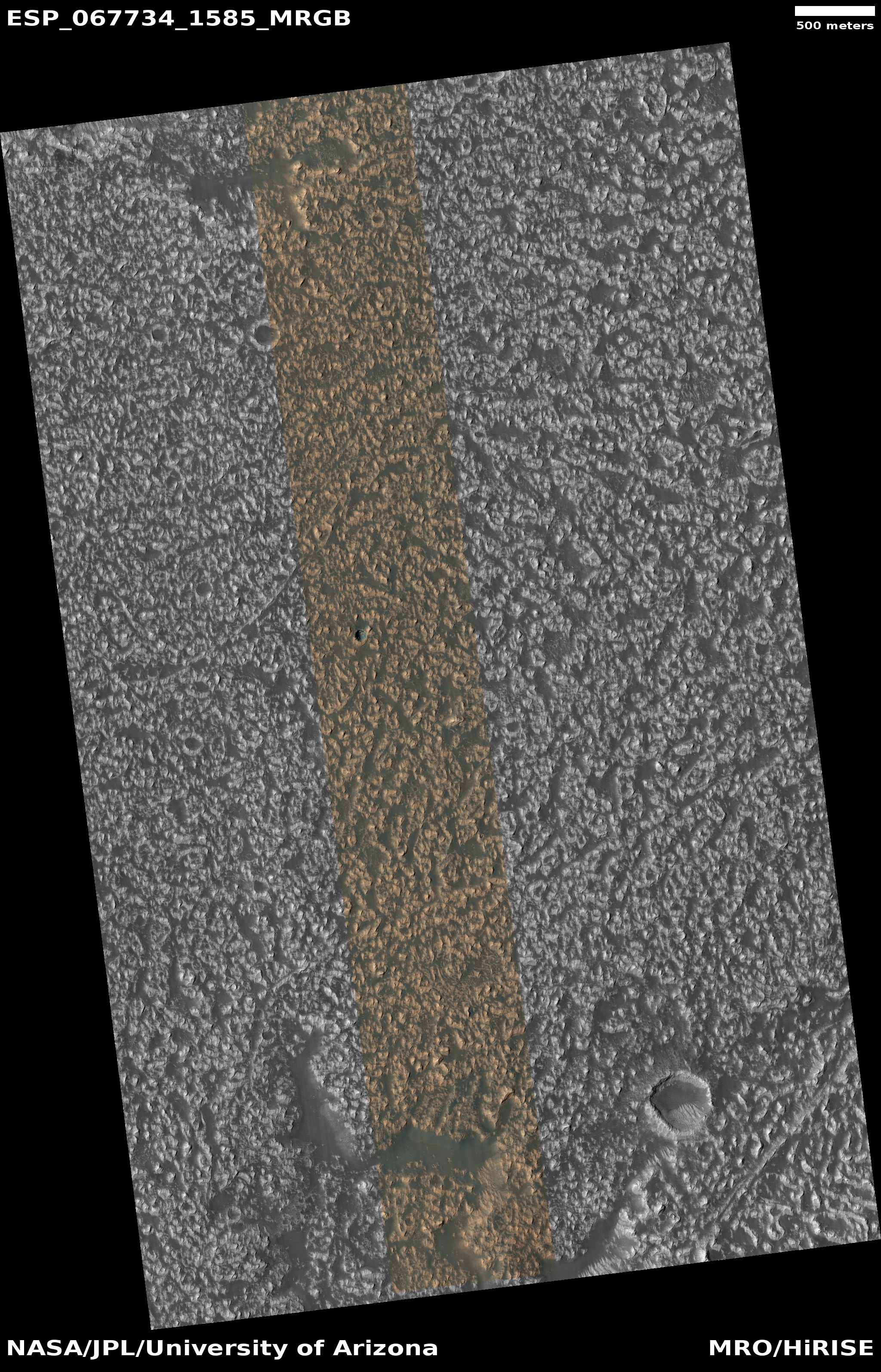
The second pit to the right, also cropped to post here, was taken on January 7, 2021, and is the farthest south pit yet documented in this volcanic region. Unlike the first pit above, it appears not as deep, and with less apparent overhang at its edges.
What makes this pit really interesting however are two features. First, there is the bluish color at the pit’s bottom. A bright blue, according to guidance [pdf] from the camera’s science team suggest either coarse rocks or frost or ice. As the pit is in the dry equatorial regions at 20 degrees south latitude, with the picture taken during summer, it is unlikely this is ice. More likely the blue color indicates the breakdown material that fell when the roof collapsed.
The possibility of ice, however is very tantalizing. Other research has found evidence of past glaciers on the western slopes of Arsia Mons, suggesting that ice might still exist in these lava tubes.
Second, there is the surrounding terrain, which is an endless scattering of small pointed knobs and ridges surrounded by dust-covered smooth hollows. The lack of craters suggests it is a relatively young lava plain. The knobs and ridges suggest to me that for some reason it has been eroded over time. A quick review of all the other high resolution images of nearby pits suggests that as you descend the southern flank of Arsia Mons, the terrain gets rougher and rougher, suggesting the lower flanks are older. This is a pure guess on my part, but does make some sense, as the flows from newer eruptions should be higher up the mountain.
Both of these pits were documented in a 2015 study that used the context camera on MRO and found more than a hundred in this region. Since then the scientists have been methodically snapping high resolution pictures of these pits. As Chris Okubo of the U.S. Geological Survey explained to me in 2019,
We are just cataloging them in the hopes that someday one of us, or someone else will have the time to investigate these further.
I will in turn continue to catalog them here, with the hope that this might encourage someone to do exactly that.

On Christmas Eve 1968 three Americans became the first humans to visit another world. What they did to celebrate was unexpected and profound, and will be remembered throughout all human history. Genesis: the Story of Apollo 8, Robert Zimmerman's classic history of humanity's first journey to another world, tells that story, and it is now available as both an ebook and an audiobook, both with a foreword by Valerie Anders and a new introduction by Robert Zimmerman.
The print edition can be purchased at Amazon or from any other book seller. If you want an autographed copy the price is $60 for the hardback and $45 for the paperback, plus $8 shipping for each. Go here for purchasing details. The ebook is available everywhere for $5.99 (before discount) at amazon, or direct from my ebook publisher, ebookit. If you buy it from ebookit you don't support the big tech companies and the author gets a bigger cut much sooner.
The audiobook is also available at all these vendors, and is also free with a 30-day trial membership to Audible.
"Not simply about one mission, [Genesis] is also the history of America's quest for the moon... Zimmerman has done a masterful job of tying disparate events together into a solid account of one of America's greatest human triumphs."--San Antonio Express-News
Love your Mars posts
While the northernmost feature looks very much like a lava pit, I’m wondering whether the southern structure is. There are a number of similar, crater-like structures in the area, and they all appear ‘oriented’ in roughly the same direction. Curious if a nearly-cooled, and still somewhat viscous, lava flow could have been impacted by a flight of rocks. Perhaps a carbonaceous asteroid got a bit too close.