
The Church – Under the Milky Way
An evening pause: With the the George Ellis Orchestra. Performed live 2026.
Hat tip Rex Ridenoure.
An evening pause: With the the George Ellis Orchestra. Performed live 2026.
Hat tip Rex Ridenoure.
Courtesy of BtB’s stringer Jay. This post is also an open thread. I welcome my readers to post any comments or additional links relating to any space issues, even if unrelated to the links below.

On Christmas Eve 1968 three Americans became the first humans to visit another world. What they did to celebrate was unexpected and profound, and will be remembered throughout all human history. Genesis: the Story of Apollo 8, Robert Zimmerman's classic history of humanity's first journey to another world, tells that story, and it is now available as both an ebook and an audiobook, both with a foreword by Valerie Anders and a new introduction by Robert Zimmerman.
The print edition can be purchased at Amazon or any other book seller. If you want an autographed copy the price is $60 for the hardback and $45 for the paperback, plus $8 shipping for each. Go here for purchasing details. The ebook is available everywhere for $5.99 (before discount) at amazon, or direct from my ebook publisher, ebookit. If you buy it from ebookit you don't support the big tech companies and the author gets a bigger cut much sooner.
"Not simply about one mission, [Genesis] is also the history of America's quest for the moon... Zimmerman has done a masterful job of tying disparate events together into a solid account of one of America's greatest human triumphs."--San Antonio Express-News
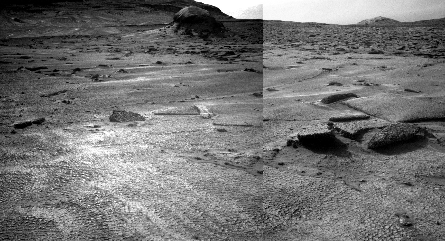
Click for full resolution. For original images, go here and here.
Click for interactive map.
Last week I noted how the terrain that stood ahead of Curiosity in its travels on Mount Sharp on Mars appeared to be the smoothest the rover had seen in years.
This week it turns out that upon closer inspection, smooth on Mars is not as smooth as it seems. The panorama above, created from two pictures taken by the rover’s left navigation camera on June 17, 2026 (here and here), provides a much closer view of that smooth ground, and revealed that it isn’t actually smooth at all, but covered with small polygons. The inset on the left shows the area in the white rectangle at full resolution, making the patterned nature of the ground very obvious. From today’s update by the science team:
From up close, the parking spot looks anything but smooth. … There are polygons, veins, lamination, and probably more, once we inspect the higher-resolution images taken today. “Higher-resolution” is the key for why we were in for such a surprise! The features are quite small, a few centimeters across, and therefore we could not see them in the orbital images or from a distance in our navigation and mast camera images. The camera resolution from a distance just isn’t enough to see them. But up close, the terrain revealed all its beauty!
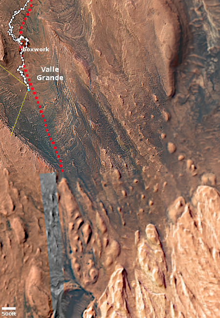
The blue dot on the overview map to the right marks Curiosity’s present position, the white dotted line its actual travels, the red dotted line its planned route. The yellow lines indicate roughly the area covered by the panorama above. The rim of Gale Crater can dimly be seen through the dusty atmosphere 20 to 30 miles away.
Explaining the geological process that caused this patterned surface is beyond my pay grade. My first guess would be it is related to the past presence of water, in the form of liquid or ice, but no one should take that guess very seriously.
As I have said many times, Mars is strange, Mars is wonderful, but above all, Mars is alien.
In what appears to be the first major space contract Boeing has won in awhile, the Space Force yesterday awarded it a $2 billion contract to build two new military communications satellites, part of the War Department’s MUOS constellation.
The Boeing Co., El Segundo, California, has been awarded a maximum $2,002,862,607 fixed-price-incentive-firm-target contract for the Mobile User Objective System (MUOS) service life extension Phase II effort. This contract provides for the design, development, build, launch support, and on-orbit test support of two MUOS satellites. Work will be performed in El Segundo, California, and is expected to be completed by Sept. 30, 2035. [emphasis mine]
Boeing won the contract competition over Lockheed Martin, which had built the previous MUOS satellites.
I highlight the fixed-price nature of the contract. Boeing’s space-related division in the past two decades has had trouble dealing with such contracts, its corporate culture having become spoiled with cost-plus contracts, which are essentially blank checks. Its fixed-price Starliner contract is the best example, but the company’s repeated inability to stay under budget or get things done got so bad that by 2020 NASA announced it would no longer entertain any contract bids from the company, a policy that it still follows.
For Boeing, making this fixed-price contract work is literally a make-or-break situation. It needs to beginning producing such contracts on-budget and on-time, or else it will die.

Now available in hardback and paperback as well as ebook!
From the press release: In this ground-breaking new history of early America, historian Robert Zimmerman not only exposes the lie behind The New York Times 1619 Project that falsely claims slavery is central to the history of the United States, he also provides profound lessons about the nature of human societies, lessons important for Americans today as well as for all future settlers on Mars and elsewhere in space.
“Zimmerman’s ground-breaking history provides every future generation the basic framework for establishing new societies on other worlds. We would be wise to heed what he says.” —Robert Zubrin, founder of the Mars Society.
All editions are available at Amazon, Barnes & Noble, and all book vendors, with the ebook priced at $5.99 before discount. All editions can also be purchased direct from the ebook publisher, ebookit, in which case you don't support the big tech companies and the author gets a bigger cut much sooner.
Autographed printed copies are also available at discount directly from the author (hardback $29.95; paperback $14.95; Shipping cost for either: $6.00). Just send an email to zimmerman @ nasw dot org.
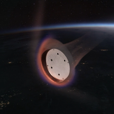
Artist’s rendering of Starfall provided during the launch live steam
In reading every report in the past day about SpaceX’s Starfall demo mission, in which it tested a returnable capsule capable of doing manufacturing in space or point-to-point transportation of cargo, the only one that appeared to provide any details about the mission itself was this article at NASAspaceflight.com.
And even those details are unconfirmed and somewhat sparse:
The Starfall demonstration vehicle stayed attached to the Falcon 9 second stage in LEO [low Earth orbit] for around 1.5 orbits. The second stage then deorbited itself and the Starfall capsule, after which Starfall was jettisoned and prepared for reentry. SpaceX released limited information about the mission, and it is unknown whether the Starfall demonstration vehicle carried any payloads, though instrumentation was likely used to measure reentry forces.
Following reentry, Starfall separated its two halves, deployed its parachutes, and splashed down in the Pacific, approximately 1,300 km off the west coast of the United States.
That’s all we presently know. Based on SpaceX’s tight-lipped approach, this mission was probably paid for by the War Department. In 2021 the Air Force had issued the company a $47.9 million contract to test point-to-point cargo transport by rocket “anywhere on the Earth in less than one hour, with a 100-ton capacity.” That cargo requirement suggested the rocket had to be Starship. It is very possible the contract was later amended to fit the 20 ton capability of Falcon 9, and this flight was the first demonstration of this cargo transport capability.
An evening pause: The song is by Chick Corea. Performed live 2025.
Hat tip Cotour.

Leaving Earth: Space Stations, Rival Superpowers, and the Quest for Interplanetary Travel, can be purchased as an ebook everywhere for only $3.99 (before discount) at amazon, Barnes & Noble, all ebook vendors, or direct from my ebook publisher, ebookit.
If you buy it from ebookit you don't support the big oppressive tech companies and I get a bigger cut much sooner.
"Leaving Earth is one of the best and certainly the most comprehensive summary of our drive into space that I have ever read. It will be invaluable to future scholars because it will tell them how the next chapter of human history opened." -- Arthur C. Clarke
Courtesy of BtB’s stringer Jay. This post is also an open thread. I welcome my readers to post any comments or additional links relating to any space issues, even if unrelated to the links below.

I recently have finished reading two books on the life and work of Leonardo da Vinci. One is not worth mentioning, as it was poorly written but had the benefit of including a lot of da Vinci’s drawings from his many manuscripts. There are many such books, and the internet makes this work even more accessible, so why plug a bad book?
The other book, however, is very much worth recommending. Charles Nicholl’s 2005 biography, Leonardo da Vinci: Flights of the Mind, is a finely detailed work that carefully documents what is know, and what is not know, about da Vinci’s life.
And there are endless uncertainties. Nicholl’s makes these clear, and then provides a lot of good background information to give the reader a good sense of where reality lies, while recognizing much of what we know about Leonardo and his life remains guesswork that can never be resolved.
What Nicholl does best however is give a much more accurate portrayal of da Vinci as an artist and scientist. The myth that exists today is that da Vinci was mostly a failed painter and sculptor who repeatedly failed to finish his projects. This is wrong. In life he was actually quite successful as a painter, his work well admired and in demand. He only failed to complete a handful of projects, and in each case the failure was not his but his client. In one case, the Sforza Horse, he was unable to cast the giant sculpture because his client sold the bronze to make war weapons. In another, The Adoration of the Magi, he failed to finish the painting because his client simply paid him too little. And in a third, the Battle of Anghiari, the client decided to make it a competition between dueling frescos by da Vinci and Michelangelo. and after learning this da Vinci chose not to participate.
In between he completed many great works, such as the Mona Lisa and the Last Supper. And in fact, even the three incomplete works above made him famous, because all three were completed enough to show their unique originality and beauty. Da Vinci had style, and his work was always stunning to the eye.
Even so, like those unfinished works, almost everything da Vinci did hold mysteries and questions that today cannot be answered. » Read more

Click for original image.
Based on spectroscopic data obtained by the Webb Space Telescope in the past year as interstellar Comet 3I/Atlas zipped through our solar system, a team of scientists have now concluded that its make-up suggests it is extremely old, as much as 12 billion years old, which means it was formed in the very early universe not that long after the Big Bang.
You can read their paper here [pdf]. The graph to the right was published by NASA of the infrared spectroscopic data produced by the Webb Space Telescope that supports this conclusion. That data shows the comet was lacking in isotopes commonly found today, while enriched in isotopes expected only in the early universe. From the paper’s abstract:
[W]e report isotopic measurements of the interstellar comet 3I/ATLAS, which reveal an elemental composition unlike any Solar System body. The water in 3I/ATLAS is enriched in deuterium, at a level of D/H = (0.98 ± 0.06)%, which is more than an order of magnitude higher than in known comets, while its range of 12[Carbon]/13[Carbon] ratios (141–191 for CO2 and 123–172 for CO) exceeds typical values found in the Solar System, as well as nearby interstellar clouds and protoplanetary disks.
Such extreme isotopic signatures indicate formation at temperatures ≲ 30 K in a relatively metal-poor environment. When interpreted with respect to models for Galactic chemical evolution, the carbon isotopic composition implies that 3I/ATLAS may have accreted as long ago as 12 billion years, following a period of intense, early star formation. 3I/ATLAS thus represents a preserved fragment of an ancient planetary system.
As the scientists add in what I think is an understatement, “Its distant origin in space and time makes 3I/ATLAS a uniquely-valuable object studies tool for Galactic archaeology.”
That the comet is still remarkable similar in many other ways to comets in our solar system also tells us that the formation processes that form all solar systems are somewhat common. The solar system in which Comet 3I/Atlas formed was different from ours only that it formed when the universe was young, and thus somewhat different in make-up. Otherwise the processes were the same.
At the same time, Comet 3I/Atlas has given us a window into the early universe, and suggests future interstellar comets will do the same. And there will be future interstellar comets, because we are now developing the observational tools to see them as they routinely fly past on a regular basis.
The Namibian government today announced it has rejected SpaceX’s application to provide Starlink to that country, apparently because the company will not comply with its laws that require ownership by Namibia citizens.
As a result, the regulator upheld its earlier ruling, stating that Starlink’s application remained non-compliant with the ownership and control requirements contained in Section 46 of the Communications Act, No. 8 of 2009. CRAN acknowledged that Low Earth Orbit satellite technology has the potential to improve connectivity across Namibia but stressed that all telecommunications operators must comply with the country’s legal and regulatory framework.
The authority also clarified that exemptions from the ownership requirements under Section 46(2) of the Communications Act can only be granted by the Minister of Information and Communication Technology and cannot be determined by CRAN through a reconsideration process.
In Africa such ownership laws almost always include a racial quota, requiring a certain percentage of ownership go specifically to blacks. SpaceX across the board refuses to do this.
The government apparently got 624 comments from the public asking it approve SpaceX’s application, but the regulators threw out all but 2 of those comments for what appears to be minor language or procedural issues.
My guess is that SpaceX refused to bribe these petty dictators, and so they denied the application.
Namibia, like South Africa, is making a foolish decision here, and as a result it is making itself a backwater, likely to trail the world in economic growth and prosperity for decades to come.
As part of its need for cash both to support its planned major capital projects and partly it appears to pay off some debt, SpaceX now plans to sell bonds in order to raise an additional $20 billion more.
The proceeds from the bond offering will mostly be used to refinance a $20 billion bridge loan SpaceX took in March as it prepared to go public. Such loans basically ensure that companies planning to go public have the money they would need to wait out an unfavorable turn in market conditions.
As the article at the link notes, however, SpaceX is hardly cash poor, having on hand over $100 billion after its initial public offering (IPO) of stock two weeks ago. On the surface this bond sale seems unnecessary, but I suspect its purpose is merely refinancing some already existing debt in order to save the company some money.
The propaganda press has been making much in the past week about the drop in SpaceX’s stock price following its original burst during the IPO, often spinning the drop as proof that SpaceX is not that valuable a company (see this NBC report for example). After raising to above $200 per share from its initial price of $135, it has since dropped to about $160. All of this is entirely normal. New stocks that capture the public’s interest all do this. The stock is simply now finding its natural market price, which by the way is still higher than that initial price.
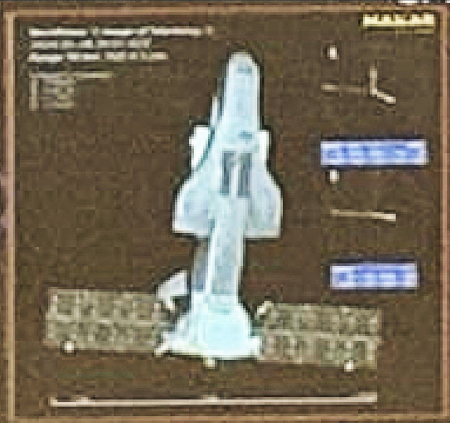
Shenlong in orbit shortly after launch.
Click for source.
According to data from the space surveillance company LeoLabs, China’s Shenlong mini-reusable shuttle — similar to the X-37B — deployed a object sometime before June 22, 2026.
At 02:30 UTC on 22 June 2026, LeoLabs detected an unknown object in the vicinity of the Chinese Shenlong reusable spaceplane.
This object did not correlate to any other object in our catalog. It was first observed by our Tracker radar in New Zealand.
This is not the first time a Shenlong in orbit released an object. On two previous flights in 2023 and 2024 it did the same. The Shenlong in orbit now was launched on February 7, 2026, the fourth mission of this X-37B copycat.
Overall, China has released very little information about Shenlong. We have no idea if the same or multiple Shenlongs have launched on the four known missions. No official pictures have ever been released, though the image of it to the right was apparently captured in orbit by amateur astronomers shortly after that February launch.

Will cosmologists ever enter?
The uncertainty of science: In apparent direct response to the June 11, 2026 press release by cosmologists claiming that their data is correct and that the universe’s expansion is accelerating in the early universe and thus dark energy must exist, a different team of scientists today issued their own press release and research paper stating that the evidence of that acceleration is faulty and based upon a false assumption about supernovae.
The original discovery of dark matter and the acceleration was based on the brightness of a certain type of supernova in the early universe, which also assumed that brightness was always the same for every explosion. The new research says otherwise.
The team analysed the supernovae from the Pantheon+ dataset, one of the most comprehensive catalogues of its kind, and incorporated a recently proposed correction that takes into account the age of the stars that eventually produce these supernova explosions. They also checked whether the inferred acceleration of the expansion rate is indeed the same in every direction, as is assumed in the standard cosmological model. “There is increasing evidence that the brightness of Type Ia supernovae depends on the age of the stars they come from,” said Professor Sarkar, a co-author of the study. “If this effect is not accounted for, it can lead to the erroneous conclusion that the expansion rate is accelerating.”
After applying the correction, the researchers found that the data no longer support a picture of a uniformly accelerating universe. Instead, their analysis suggests that cosmic expansion is overall slowing down rather than speeding up.
Their conclusion is blunt: “There is thus no evidence for isotropic accelerated expansion of the Universe, which can be ascribed to either a Cosmological Constant or more general dark energy.”
In other words, there is solid disagreement within the cosmological community about the existence of dark energy. Some believe it exists, based on the supernova data. Some do not, because the data depends on too many assumptions about those supernovae that further observations suggest are wrong.
Since yesterday there were two more launches by the global rocket industry.
First, China placed a “communication technology experimental satellite” into orbit, its Long March 7A rocket lifting off from its coastal Wenchang spaceport. No other information was provided.
Artist’s rendering of Starfall provided during today’s live steam
Next, SpaceX launched in the early morning the first demo mission for its Starfall recoverable capsule, its Falcon 9 rocket lifting off from Cape Canaveral Space Force Station in Florida. The company has released little information about this project, including not showing the deployment or splashdown of Starfall in the launch broadcast. Its short description of Starfall during the live stream made it sound very similar to Varda’s recoverable capsule, though larger. According to Wikipedia,
Starfall has a circular, disk-shaped form measuring 10′ in diameter and 2′ 6″ in height. Its empty mass is 2,100 kg (4,600 lb). Starfall carries up to 1,000 kilograms of payload in a volume of 2.5 by 0.5 meters and a total mass of about 3,100 kilograms. The vehicle consists of a top plate with maneuvering thrusters and a heat shield that jettisons before a parachute assisted splashdown. Starfall reaches orbit as a payload on Falcon 9 or Starship. The design focuses on precision delivery to specific locations, supporting rapid delivery for critical cargo.
The company has at this time provided no information about the results of this demo mission.
The rocket’s two fairings completed their 24th and 36th flights respectively. The first stage (B1078) completed its 29th flight (29 days after its previous mission), landing on a drone ship in the Atlantic. With this flight this booster moved past the space shuttle Columbia into a seventh place tie in the rankings for the most reused launch vehicle:
39 Discovery space shuttle
35 Falcon 9 booster B1067
34 Falcon 9 booster B1071
33 Atlantis space shuttle
33 Falcon 9 booster B1063
31 Falcon 9 booster B1069
29 Falcon 9 booster B1077
29 Falcon 9 booster B1078
28 Columbia space shuttle
The leaders in the 2026 launch race:
75 SpaceX
41 China
9 Rocket Lab (plus two suborbital HASTE launches)
8 Russia
For the third straight year SpaceX leads the entire world combined in total launches, 75 to 70.
NASA yesterday announced that the Republic of Botswana will sign the Artemis Accords on June 25, 2026, becoming the 68th nation to join this American alliance in space.
The Republic of Botswana will sign the Artemis Accords during a ceremony at 9:30 a.m. EDT Thursday, June 25, at NASA Headquarters in Washington. NASA Deputy Administrator Matt Anderson will host Botswana’s Minister of Communications and Innovation David Tshere and U.S. Department of State Senior Advisor for Space Gregory Autry for the event.
Since NASA administrator Jared Isaacman took over, the NASA press releases announcing these signings have eliminated much of the pro-globalist language introduced during the Biden administration. No longer does NASA claim the accords are designed to “reinforce” the Outer Space Treaty. In today’s release the language is relatively vague, stating merely that the accords are
responding to the growing interest in lunar activities by both governments and private companies. The accords introduced the first set of practical principles aimed at enhancing the safety, transparency, and coordination of civil space exploration on the Moon, Mars, and beyond.
As the accords were originally conceived by Trump as a long term tool to overcome the Outer Space Treaty’s restrictions on private property and the establishment of American law in its colonies, this vagueness is likely intended to avoid antagonizing Russia and China, to lull them into apathy about the issue at this time. Later, when the U.S. Moon base is largely established expect that vagueness to fade. That will be the time to use the clout of this large alliance to force a major legal change in this international treaty.
The full list of nations in this American space alliance is as follows:
Angola, Argentina, Armenia, Australia, Austria, Bahrain, Bangladesh, Belgium, Brazil, Botswana, Bulgaria, Canada, Chile, Colombia, Cyprus, Czech Republic, Denmark, Dominican Republic, Ecuador, Estonia, Finland, France, Germany, Greece, Hungary, Iceland, India, Ireland, Israel, Italy, Japan, Jordan, Latvia, Liechtenstein, Lithuania, Luxembourg, Malaysia, Malta, Mexico, Morocco, the Netherlands, New Zealand, Nigeria, Norway, Oman, Panama, Paraguay, Peru, Poland, Portugal, Romania, Rwanda, Saudi Arabia, Senegal, Singapore, Slovakia, Slovenia, South Korea, Spain, Sweden, Switzerland, Thailand, the Philippines, the United Kingdom, the United Arab Emirates, the Ukraine, the United States and Uruguay.
An evening pause: A bit of history about a clever technology that simply will not die.
Courtesy of BtB’s stringer Jay. This post is also an open thread. I welcome my readers to post any comments or additional links relating to any space issues, even if unrelated to the links below.
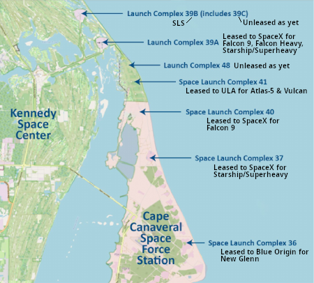
Figure 2 of IG report, annotated further by me.
According to a report released today [pdf] by NASA’s inspector general (IG), NASA’s launch infrastructure at both the Kennedy Space Center in Florida and the Wallops Flight Facility in Virginia are aging and need upgrades, but there is a systemic limitation on NASA’s access to funds to do the work.
The IG report — as is always expected from such a government report — of course whines about the lack of funding in recent NASA budgets, noting that Congress recently allocated $250 million for this purpose, but NASA claims it needs four times that amount, or $1 billion.
The report however also recognizes that this not the real problem. The map to the right, Figure 2 from the report, has been further annotated by me to show who is leasing or using each launch complex at both the Kennedy Space Center (managed by NASA) and Cape Canaveral Space Force Station (managed by the military but also supported significantly by NASA). As you can see, almost all launch sites are either leased by private rocket companies, or are being primed for future such leases. Yet, “statutory funding barriers” limit how much money NASA can collect from these companies. From the report’s conclusion:
» Read more

Figure 1 from the paper. Click for original.
Using ground-based radio telescopes, astronomers have now discovered a very strange asymmetrical radio galaxy squashed into a gigantic arc almost two million light years across as the galaxy pushes its way into the surrounding material of an even more gigantic galactic cluster.
In RAD-BAARG [the name they have given the galaxy], the researchers say one of the jets appears to interact with a large bow shock-like structure formed as the host galaxy falls through the surrounding hot gas toward a nearby cluster of galaxies. Similar to the shockwave formed ahead of a supersonic aircraft, a galaxy moving faster than the speed of sound in the surrounding intracluster medium can compress the ambient gas and generate a large-scale shock front.
The radio-emitting plasma from RAD-BAARG appears to illuminate this otherwise extremely faint structure, making it visible in low-frequency radio images, according to the team. The western side of the source contains a narrow jet feeding a sector-shaped emission region and a giant arc-like feature extending over nearly 560 kiloparsecs (1.8 million light years).
On the opposite side, the jet develops a distorted S-shaped morphology followed by a faint offset tail extending to almost 600 kiloparsecs. The overall structure suggests strong interaction between the radio plasma and the surrounding large-scale environment.
You can read their published paper here. The images to the right are figure 1 from that paper. The top image is just the radio data. The bottom image shows the contours of that radio data over the optical view. The cross marks the location of object’s host galaxy, as seen in the optical.
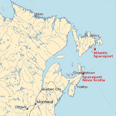
Proposed Canadian spaceports
The Canadian rocket startup Nordspace, which also hopes to operate the Atlantic Spaceport in Newfoundland, last week announced the opening of a new headquarters where it hopes to begin building its smallsat Tundra rockets.
The 60,000 square foot advanced manufacturing campus is dedicated to the production of the company’s light and medium-lift orbital launch vehicles alongside its space systems division, and represents a 10x expansion over NordSpace’s previous headquarters.
In reading between the lines of the press release, it appears this facility is mostly the company’s administrative and operations headquarters, though it is large enough to assembly two Tundra smallsat rockets at the same time, designed to put about three times more payload into orbit than Rocket Lab’s very successful Electron rocket.
Unlike Spaceport Nova Scotia, which was first proposed more than a decade ago and after years of struggle was leased in March by the Canadian government for $200 million, Nordspace has only been around since 2024 and has received a relatively small grant from the government, some portion of a $8.3 million program to support three Canadian rocket startups.
With both spaceports, there has been a lot of blarney spouted. Thus, separating the sizzle from the steak is difficult. No launch dates for Tundra have been provided, though the company says it has purchased the land for an even larger manufacturing facility, though once again it provides no timetables.