Firefly announces new stock sale aimed at raising more than a half billion in new funds
The publicly traded rocket/lunar lander company Firefly yesterday announced a new public offering of stock, totalling more than 12 million shares, with the goal of raising more than a half billion for “general corporate purposes.”
Firefly Aerospace (Nasdaq: FLY), a market leading space and defense technology company, today announced the pricing of its public offering of 4,000,000 shares of its common stock and 8,000,000 shares of common stock by certain selling stockholders (the “Offering”) at a public offering price of $48.00 per share. In addition, the selling stockholders have granted the underwriters a 30-day option to purchase up to an additional 1,800,000 shares of common stock at the public offering price, less underwriting discounts and commissions. The Offering is expected to close on June 1, 2026, subject to customary closing conditions.
Firefly intends to use the net proceeds from the Offering for general corporate purposes, including to support growth of core business and recently awarded programs and initiatives. Firefly will not receive any of the proceeds from the sale of shares by the selling stockholders.
Click for source.
Simple math says this offering hopes to raise $576 million dollars, assuming the $48 per share price holds.
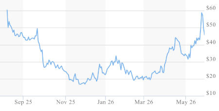
The graph to the right shows the full price history of Firefly’s stock since the initial public offering in 2025. After an initial high around $60, the stock sagged to around $20, and only has recovered back into the $40 to $50 range in the past few months. It appears therefore that the company has well timed this new offering.